Wyoming Highway 173
Wyoming Highway 173 (WYO 173) is a short 1.61-mile-long (2.59 km) Wyoming state road located in Hot Springs County south of Thermopolis.
Wyoming Highway 173 | ||||
|---|---|---|---|---|
| Buffalo Creek Road | ||||
WYO 173 highlighted in red | ||||
| Route information | ||||
| Maintained by WYDOT | ||||
| Length | 1.61 mi[1] (2.59 km) | |||
| Major junctions | ||||
| West end | ||||
| East end | ||||
| Location | ||||
| Country | United States | |||
| State | Wyoming | |||
| Counties | Hot Springs | |||
| Highway system | ||||
| ||||
| ||||
Route description

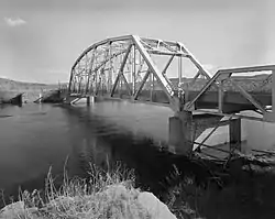
Wyoming Highway 173 begins its west end at US 20/WYO 789 just over a mile and a half south of Thermopolis. Named Buffalo Creek Road, Highway 173 travels southeasterly along the south bank of the Bighorn River. At 1.42 miles, WYO 173 crosses the river via the CQA Four Mile Bridge which is listed on the National Register of Historic Places.[2] Two-tenths of a mile later WYO 173 reaches its end at County Route 31 (South Yellowstone Road).[3] CR 31 continues another 1.6 miles south and returns to US 20/WYO 789.
History
The original Four Mile Bridge, which carried Highway 173 over the Big Horn River, was completed in 1928 and was added to the National Register of Historic Places as part of a forty-bridge collection that illustrate steel truss construction.[2] It was offered for sale by the Wyoming Highway Department in 1987 ahead of a planned replacement.[4] The project to improve Highway 173 and replace the bridge was part of a 1984 agreement to eventually transfer control to Hot Springs County, but the county government declined to assume responsibility in 1993.[5]
Major intersections
The entire route is in Hot Springs County.
| Location | mi[1] | km | Destinations | Notes | |
|---|---|---|---|---|---|
| | 0.00 | 0.00 | Western terminus of WYO 171 | ||
| | 1.61 | 2.59 | Eastern terminus of WYO 171 | ||
| 1.000 mi = 1.609 km; 1.000 km = 0.621 mi | |||||
See also
References
- Wyoming Department of Transportation Reference Marker Book (PDF) (Map). WYDOT. November 2004. Archived from the original (PDF) on July 17, 2011. Retrieved February 14, 2012.
- Fraser, Clayton B. (May 4, 1982). "National Register of Historic Places Inventory - Nomination Form: CQA Four Mile Bridge". National Park Service. p. 12. Retrieved 2012-02-26.
- Google (February 26, 2012). "Overview Map of Wyoming Highway 173" (Map). Google Maps. Google. Retrieved February 26, 2012.
- Kirshner, Erich (August 17, 1987). "Psssst, buddy! Want a bridge?". Casper Star-Tribune. p. B1. Retrieved June 24, 2023 – via Newspapers.com.
- "DOT wants rid of road; Hot Springs doesn't want it". Casper Star-Tribune. April 17, 1993. p. B1. Retrieved June 24, 2023 – via Newspapers.com.
