Xianghe County
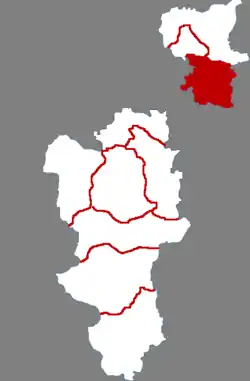
Xianghe County (simplified Chinese: 香河县; traditional Chinese: 香河縣; pinyin: Xiānghé Xiàn) is a county of central Hebei province. It is under the administration of Langfang prefecture-level city. Xianghe has 7 towns and 2 townships. It is 45 kilometres (28 mi) southeast of Beijing.
Xianghe County
香河县 Siangho | |
|---|---|
 Xianghe in Langfang | |
.png.webp) Langfang in Hebei | |
| Coordinates: 39°45′40″N 117°00′22″E | |
| Country | People's Republic of China |
| Province | Hebei |
| Prefecture-level city | Langfang |
| Seat | Shuyang Town (淑阳镇) |
| Area | |
| • Total | 458 km2 (177 sq mi) |
| Population (2004) | |
| • Total | 310,000 |
| • Density | 680/km2 (1,800/sq mi) |
| Time zone | UTC+8 (China Standard) |
| Postal code | 065400 |
| Area code | 0316 |
| Website | www |
Sanhe city, Dachang Hui Autonomous County and Xianghe County form the "Northern Three Counties of Langfang", an exclave of Hebei province surrounded by the municipalities of Beijing and Tianjin.
Administrative divisions
Towns:[1]
- Shuyang (淑阳镇), Jiangxintun (蒋辛屯镇), Qukou (渠口镇), Antoutun (安头屯镇), Anping (安平镇), Liusong (刘宋镇), Wubaihu (五百户镇)
Townships:[1]
- Qianwang Township (钱旺乡), Qiantun Township (钳屯乡)
Climate
| Climate data for Xianghe (1991–2020 normals, extremes 1981–2010) | |||||||||||||
|---|---|---|---|---|---|---|---|---|---|---|---|---|---|
| Month | Jan | Feb | Mar | Apr | May | Jun | Jul | Aug | Sep | Oct | Nov | Dec | Year |
| Record high °C (°F) | 13.9 (57.0) |
19.9 (67.8) |
29.4 (84.9) |
32.0 (89.6) |
38.2 (100.8) |
39.2 (102.6) |
40.7 (105.3) |
36.6 (97.9) |
34.6 (94.3) |
30.8 (87.4) |
21.6 (70.9) |
13.6 (56.5) |
40.7 (105.3) |
| Average high °C (°F) | 2.0 (35.6) |
5.9 (42.6) |
13.0 (55.4) |
20.9 (69.6) |
27.0 (80.6) |
30.8 (87.4) |
31.9 (89.4) |
30.8 (87.4) |
26.7 (80.1) |
19.4 (66.9) |
10.2 (50.4) |
3.3 (37.9) |
18.5 (65.3) |
| Daily mean °C (°F) | −3.7 (25.3) |
−0.3 (31.5) |
6.6 (43.9) |
14.5 (58.1) |
20.6 (69.1) |
24.8 (76.6) |
26.9 (80.4) |
25.7 (78.3) |
20.6 (69.1) |
13.1 (55.6) |
4.5 (40.1) |
−1.9 (28.6) |
12.6 (54.7) |
| Average low °C (°F) | −8.1 (17.4) |
−5.0 (23.0) |
1.2 (34.2) |
8.5 (47.3) |
14.5 (58.1) |
19.5 (67.1) |
22.8 (73.0) |
21.7 (71.1) |
15.9 (60.6) |
8.2 (46.8) |
0.1 (32.2) |
−5.9 (21.4) |
7.8 (46.0) |
| Record low °C (°F) | −21.2 (−6.2) |
−18.1 (−0.6) |
−12.2 (10.0) |
−2.6 (27.3) |
3.1 (37.6) |
9.4 (48.9) |
15.5 (59.9) |
13.5 (56.3) |
3.9 (39.0) |
−5.1 (22.8) |
−11.2 (11.8) |
−20.8 (−5.4) |
−21.2 (−6.2) |
| Average precipitation mm (inches) | 2.9 (0.11) |
5.3 (0.21) |
7.5 (0.30) |
21.4 (0.84) |
40.4 (1.59) |
77.0 (3.03) |
163.6 (6.44) |
114.1 (4.49) |
49.4 (1.94) |
29.4 (1.16) |
15.3 (0.60) |
2.6 (0.10) |
528.9 (20.81) |
| Average precipitation days (≥ 0.1 mm) | 1.6 | 2.2 | 2.7 | 4.6 | 6.6 | 9.8 | 11.8 | 9.7 | 6.3 | 4.7 | 3.0 | 1.7 | 64.7 |
| Average snowy days | 2.4 | 2.0 | 0.9 | 0.1 | 0 | 0 | 0 | 0 | 0 | 0 | 1.4 | 2.6 | 9.4 |
| Average relative humidity (%) | 50 | 49 | 47 | 49 | 55 | 64 | 74 | 77 | 72 | 66 | 61 | 54 | 60 |
| Mean monthly sunshine hours | 175.7 | 179.1 | 228.2 | 240.2 | 267.1 | 231.7 | 203.8 | 216.2 | 213.4 | 200.9 | 163.8 | 161.7 | 2,481.8 |
| Percent possible sunshine | 58 | 59 | 61 | 60 | 60 | 52 | 45 | 51 | 58 | 59 | 55 | 56 | 56 |
| Source: China Meteorological Administration[2][3] | |||||||||||||
Grand Epoch City
The "Grand Epoch City" located in the Xianghe Economic & Technical Development Zone of Hebei Province[4] is a 1/6th scale model of the old walled city of Beijing. It covers an area of 200 hectares (490 acres) and contains temples, fountains, ponds, a 27-hole golf course among other things and has hundred of thousands of replicas; all within the "city's" walls.[5]
Its total area covers 2,660,000 square metres (29,000,000 sq ft) with 470,000 square metres (5,100,000 sq ft) of building floor space. The city was built with a total investment of RMB 3 billion (approx. $481.3 million USD).[4]
References
- http://www.xzqh.org/html/list/46.html廊坊市-行政区划网
- 中国气象数据网 – WeatherBk Data (in Simplified Chinese). China Meteorological Administration. Retrieved 26 August 2023.
- 中国气象数据网 (in Simplified Chinese). China Meteorological Administration. Retrieved 26 August 2023.
- "Xianghe Grand Epoch City-Tourist Attractions-English.lf.gov.cn". Archived from the original on May 6, 2016. Retrieved February 9, 2013.
- "China Plus". Archived from the original on October 17, 2007.