Kızılcahamam
Kızılcahamam is a municipality and district of Ankara Province, Turkey.[2] Its area is 1,623 km2,[3] and its population is 26,872 (2022).[1] It is 70 km north of the city of Ankara, near the motorway to Istanbul. Its elevation is 975 m. The area is mountain and forest, a geographical boundary between central Anatolia and the Black Sea regions.
Kızılcahamam | |
|---|---|
District and municipality | |
.jpg.webp) A nature scene from Kızılcahamam | |
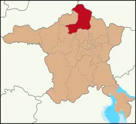 Map showing Kızılcahamam District in Ankara Province | |
 Kızılcahamam Location in Turkey 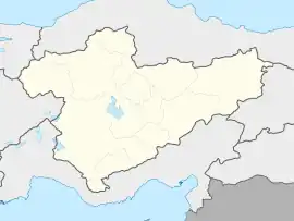 Kızılcahamam Kızılcahamam (Turkey Central Anatolia) | |
| Coordinates: 40°28′11″N 32°39′02″E | |
| Country | Turkey |
| Province | Ankara |
| Government | |
| • Mayor | Süleyman Acar (AKP) |
| Area | 1,623 km2 (627 sq mi) |
| Elevation | 975 m (3,199 ft) |
| Population (2022)[1] | 26,872 |
| • Density | 17/km2 (43/sq mi) |
| Time zone | TRT (UTC+3) |
| Area code | 0312 |
| Website | www |
Kızılcahamam itself is a quiet market town known for its healing hot springs and mineral waters. Nearby Soğuksu National Park contains a scout camp and trails, and areas for picnic in the forest. There are hotels and guest houses including spa hotels. A sculpture of black vulture, an endangered bird species inhabited in the national park, is situated at the entrance of the town.[4]
Climate
The climate in Kızılcahamam is dominated by hot and temperate/mesothermal climate. In winter more precipitation falls than in the summer season. The climate can be classified as Mediterranean climate (Csb) according to Köppen–Geiger climate system. Annual average temperature is 10.4 °C (50.7 °F) and the average annual rainfall 550 mm (22 in).
| Climate data for Kızılcahamam | |||||||||||||
|---|---|---|---|---|---|---|---|---|---|---|---|---|---|
| Month | Jan | Feb | Mar | Apr | May | Jun | Jul | Aug | Sep | Oct | Nov | Dec | Year |
| Daily mean °C (°F) | −0.4 (31.3) |
1.2 (34.2) |
5.1 (41.2) |
9.9 (49.8) |
14.0 (57.2) |
17.3 (63.1) |
20.4 (68.7) |
20.1 (68.2) |
16.6 (61.9) |
11.5 (52.7) |
6.5 (43.7) |
2.1 (35.8) |
10.4 (50.7) |
| Average precipitation mm (inches) | 70 (2.8) |
53 (2.1) |
51 (2.0) |
53 (2.1) |
64 (2.5) |
43 (1.7) |
22 (0.9) |
20 (0.8) |
23 (0.9) |
31 (1.2) |
42 (1.7) |
78 (3.1) |
550 (21.8) |
| Source: Values of Annual Mean Temperature and Precipitation Distribution by Months.[5] | |||||||||||||
Composition
There are 109 neighbourhoods in Kızılcahamam District:[6]
- Akçakese
- Akçaören
- Akçay
- Akdoğan
- Aksak
- Alibey
- Alpagut
- Aşağıada
- Aşağıçanlı
- Aşağıhüyük
- Ayvacık
- Bademli
- Bağlıca
- Bağören
- Balcılar
- Başağaç
- Başören
- Bayır
- Belpınar
- Berçinçatak
- Berçinyayalar
- Beşkonak
- Bezcikuzören
- Binkoz
- Bulak
- Çavuşlar
- Çeltikçi
- Çeştepe
- Ciğirler
- Çırpan
- Çukurca
- Çukurören
- Değirmenönü
- Demirciören
- Dereneci
- Doğanözü
- Doymuşören
- Eğerlialören
- Eğerlibaşköy
- Eğerlidere
- Eğerlikozören
- Esenler
- Gebeler
- Gökbel
- Gölköy
- Gümele
- Güneysaray
- Güvem
- Hıdırlar
- İğdir
- İğmir
- İnceğiz
- İsmetpaşa
- İyceler
- Kalemler
- Karaağaç
- Karacaören
- Karşıyaka
- Kasımlar
- Kavaközü
- Kemalpaşa
- Kınık
- Kırkırca
- Kırköy
- Kışlak
- Kızık
- Kızılcaköy
- Kızılcaören
- Kocalar
- Kurumcu
- Kuşcuören
- Mahkemeağcin
- Oğlakcı
- Olucak
- Örencik
- Ortaköy
- Otacı
- Pazar
- Pazar Başören
- Pazar Kınık
- Şahinler
- Salın
- Saray
- Saraycık
- Sazak
- Semeler
- Semer
- Süleler
- Tahtalar
- Taşlıca
- Turnalı
- Üçbaş
- Uğurlu
- Üyücek
- Yağcıhüseyin
- Yakakaya
- Yanık Özbekler
- Yenice
- Yeşilköy
- Yıldırımçatak
- Yıldırımdemirciler
- Yıldırımhacılar
- Yıldırımören
- Yıldırımyağlıca
- Yukarıada
- Yukarıçanlı
- Yukarıhüyük
- Yukarıkaraören
- Yukarıkese
References
- "Address-based population registration system (ADNKS) results dated 31 December 2022, Favorite Reports" (XLS). TÜİK. Retrieved 22 May 2023.
- Büyükşehir İlçe Belediyesi, Turkey Civil Administration Departments Inventory. Retrieved 8 June 2023.
- "İl ve İlçe Yüz ölçümleri". General Directorate of Mapping. Retrieved 22 May 2023.
- "Soğuksu Milli Parkı" (in Turkish). Orman ve Su İşleri Bakanlığı 9. Bölge Müdürülüğü. Archived from the original on 2018-08-06. Retrieved 2016-04-02.
- "İklim: Kızılcahamam" (in Turkish). Climate-Data. Retrieved 2016-04-18.
- Mahalle, Turkey Civil Administration Departments Inventory. Retrieved 22 May 2023.
External links
- District governor's official website (in Turkish)
- District municipality's official website (in Turkish)
Kızılcahamam in Ankara Province of Turkey | |||||||||||||||||||||||||||
|---|---|---|---|---|---|---|---|---|---|---|---|---|---|---|---|---|---|---|---|---|---|---|---|---|---|---|---|
| Districts |  Districts of Ankara | ||||||||||||||||||||||||||
| |||||||||||||||||||||||||||
Metropolitan municipalities are bolded. | |||||||||||||||||||||||||||