Yame
Yame (八女市, Yame-shi) is a city located in Fukuoka Prefecture, Japan. The city was founded on April 1, 1954.
Yame
八女市 | |
|---|---|
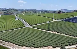 Yame Tea Plantation | |
 Flag  Seal | |
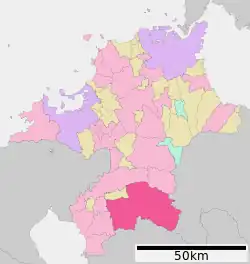
Location of Yame in Fukuoka Prefecture | |
 | |
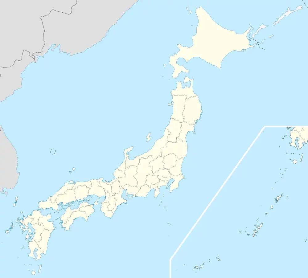 Yame Location in Japan | |
| Coordinates: 33°11′58″N 130°33′32″E | |
| Country | Japan |
| Region | Kyushu |
| Prefecture | Fukuoka Prefecture |
| Government | |
| • Mayor | Tsuneyuki Mitamura (since November 2008) |
| Area | |
| • Total | 482.53 km2 (186.31 sq mi) |
| Population (April 1, 2011) | |
| • Total | 69,907 |
| • Density | 140/km2 (380/sq mi) |
| Time zone | UTC+09:00 (JST) |
| City hall address | Honmachi 647, Yame, Fukuoka (福岡県八女市本町647) 834-8585 |
| Climate | Cfa |
| Website | www |
| Symbols | |
| Flower | Chrysanthemum, Wisteria, Hymenanthes |
| Tree | Tea, Cinnamonum camphora |
As of 2003, the city had an estimated population of 39,372 and a population density of 1,000.81 persons per km². The total area was 39.34 km².
On October 1, 2006 the town of Jōyō (from Yame District) was merged into Yame.
On February 1, 2010, the towns of Kurogi and Tachibana, and the villages of Hoshino and Yabe (all from Yame District) were merged into Yame.
After the merger, as of April 1, 2011, the city has an estimated population of 69,907, with 23,885 households and a population density of 144.88 persons per km². The total area is 482.53 km², which is second largest area within Fukuoka Prefecture.
Yamecha is produced in Yame and surrounding areas, and is a tea known throughout Japan.
Yame natives include former livedoor CEO Takafumi Horie and NiziU leader Mako Yamaguchi (山口真子).
Geography
Climate
Yame has a humid subtropical climate (Köppen: Cfa). The average annual temperature in Yame is 15.4 °C (59.7 °F). The average annual rainfall is 2,058.1 mm (81.03 in) with July as the wettest month. The temperatures are highest on average in August, at around 26.7 °C (80.1 °F), and lowest in January, at around 4.1 °C (39.4 °F).[1] The highest temperature ever recorded in Yame was 39.2 °C (102.6 °F) on 16 July 1994; the coldest temperature ever recorded was −7.9 °C (17.8 °F) on 25 January 2016.[2]
| Climate data for Kurogi, Yame (1991−2020 normals, extremes 1977−present) | |||||||||||||
|---|---|---|---|---|---|---|---|---|---|---|---|---|---|
| Month | Jan | Feb | Mar | Apr | May | Jun | Jul | Aug | Sep | Oct | Nov | Dec | Year |
| Record high °C (°F) | 20.9 (69.6) |
23.3 (73.9) |
25.2 (77.4) |
30.8 (87.4) |
34.8 (94.6) |
36.3 (97.3) |
39.2 (102.6) |
38.7 (101.7) |
36.2 (97.2) |
32.6 (90.7) |
26.4 (79.5) |
23.9 (75.0) |
39.2 (102.6) |
| Average high °C (°F) | 9.4 (48.9) |
11.2 (52.2) |
14.9 (58.8) |
20.4 (68.7) |
25.2 (77.4) |
27.4 (81.3) |
31.0 (87.8) |
32.4 (90.3) |
28.9 (84.0) |
23.7 (74.7) |
17.7 (63.9) |
11.6 (52.9) |
21.2 (70.1) |
| Daily mean °C (°F) | 4.1 (39.4) |
5.4 (41.7) |
8.8 (47.8) |
13.9 (57.0) |
18.7 (65.7) |
22.3 (72.1) |
26.0 (78.8) |
26.7 (80.1) |
23.2 (73.8) |
17.5 (63.5) |
11.7 (53.1) |
6.1 (43.0) |
15.4 (59.7) |
| Average low °C (°F) | −0.5 (31.1) |
0.3 (32.5) |
3.3 (37.9) |
7.8 (46.0) |
12.7 (54.9) |
18.0 (64.4) |
22.3 (72.1) |
22.5 (72.5) |
18.8 (65.8) |
12.5 (54.5) |
6.6 (43.9) |
1.4 (34.5) |
10.5 (50.8) |
| Record low °C (°F) | −7.9 (17.8) |
−7.4 (18.7) |
−5.1 (22.8) |
−2.6 (27.3) |
3.9 (39.0) |
7.3 (45.1) |
13.5 (56.3) |
14.0 (57.2) |
6.2 (43.2) |
0.9 (33.6) |
−2.2 (28.0) |
−5.5 (22.1) |
−7.9 (17.8) |
| Average precipitation mm (inches) | 59.0 (2.32) |
83.3 (3.28) |
129.9 (5.11) |
151.7 (5.97) |
183.8 (7.24) |
388.5 (15.30) |
414.3 (16.31) |
227.1 (8.94) |
182.2 (7.17) |
86.7 (3.41) |
87.2 (3.43) |
64.6 (2.54) |
2,058.1 (81.03) |
| Average precipitation days (≥ 1.0 mm) | 8.6 | 8.8 | 11.0 | 10.5 | 9.7 | 13.9 | 13.7 | 11.1 | 9.8 | 6.7 | 8.1 | 8.3 | 120.2 |
| Mean monthly sunshine hours | 116.8 | 129.7 | 162.0 | 183.1 | 192.9 | 121.8 | 161.9 | 197.3 | 166.9 | 177.2 | 143.4 | 124.3 | 1,877.4 |
| Source: Japan Meteorological Agency[1][2] | |||||||||||||
Demographics
Per Japanese census data, the population of Yame in 2020 is 60,608 people.[3] Yame has been conducting censuses since 1950.
| Year | Pop. | ±% |
|---|---|---|
| 1950 | 105,194 | — |
| 1955 | 105,820 | +0.6% |
| 1960 | 101,573 | −4.0% |
| 1965 | 93,353 | −8.1% |
| 1970 | 88,888 | −4.8% |
| 1975 | 85,736 | −3.5% |
| 1980 | 85,078 | −0.8% |
| 1985 | 84,556 | −0.6% |
| 1990 | 81,895 | −3.1% |
| 1995 | 79,492 | −2.9% |
| 2000 | 76,689 | −3.5% |
| 2005 | 73,262 | −4.5% |
| 2010 | 69,053 | −5.7% |
| 2015 | 64,408 | −6.7% |
| 2020 | 60,608 | −5.9% |
| Yame population statistics[3] | ||
See also
References
- 気象庁 / 平年値(年・月ごとの値). JMA. Retrieved May 21, 2022.
- 観測史上1~10位の値(年間を通じての値). JMA. Retrieved May 21, 2022.
- Yame population statistics
External links
 Media related to Yame, Fukuoka at Wikimedia Commons
- Yame City official website (in Japanese)
- Brief introduction of Yame tea (in English)