Yangcun Subdistrict
Yangcun Subdistrict (simplified Chinese: 杨村街道; traditional Chinese: 楊村街道; pinyin: Yángcūn Jiēdào) is a subdistrict located in the south portion of Wuqing District, Tianjin, China. It shares border with Xuguantun Subdistrict in its north, Meichang Town in its east, Xiazhuzhuang Subdistrict in its south, and Yunhexi Subdistrict in its west. As of 2010, it is home to a population of 45,947.[1]
Yangcun Subdistrict
杨村街道 | |
|---|---|
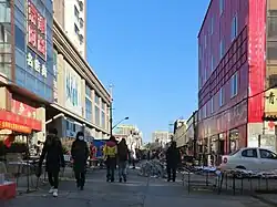
 Shopping street in Shengli Lu Residential Community within the subdistrict. | |
 Yangcun Subdistrict  Yangcun Subdistrict | |
| Coordinates: 39°22′49″N 117°04′11″E | |
| Country | |
| Municipality | Tianjin |
| District | Wuqing |
| Village-level Divisions | 13 communities |
| Area | |
| • Total | 15.86 km2 (6.12 sq mi) |
| Elevation | 7 m (23 ft) |
| Population (2010) | |
| • Total | 45,947 |
| • Density | 2,900/km2 (7,500/sq mi) |
| Time zone | UTC+8 (CST) |
| Postal code | 301700 |
| Area code | 022 |
The area was named "Yangcun" (Chinese: 杨村; lit. 'Yang's Village') due to Yang being the dominant family at the founding of the settlement in the Song dynasty.[2]
Geography
Yangcun Subdistrict is located to the east of the Grand Canal. The National Highway 103 passes through its west. Its average elevation is 7 meters above the sea level.[3]
History
| Years | Status | Part of |
|---|---|---|
| 1950 - 1958 | Yangcun Town | Wuqing County, Hebei |
| 1958 - 1973 | Yangcun People's Commune | |
| 1973 - 1982 | Wuqing County, Tianjin | |
| 1982 - 2000 | Yangcun Town | |
| 2000 - 2001 | Wuqing District, Tianjin | |
| 2001 - present | Yangcun Subdistrict |
Administrative divisions
As of the year 2022, Yangcun Subdistrict oversees 13 residential communities. They are listed as follows:[4]
- Wenhua Xiang (文华巷)
- Tuanjie Lu (团结路)
- Shengli Lu (胜利路)
- Nanlou (南楼)
- Zhanbei Lu (站北路)
- Yucai Nanli (育才南里)
- Youyi Li (友谊里)
- Dongwang Xiang (东旺巷)
- Yangguang Jiayuan (阳光家园)
- Jinhui Wan (金汇湾)
- Xinwan Huayuan Dong (新湾花园东)
- Xinwan Huayuan Xi (新湾花园西)
- Yunze Huayuan (运泽花园)
Galleries
.jpg.webp) Yangcun Railway Station on the south of the subdistrict
Yangcun Railway Station on the south of the subdistrict Yishou Pavilion
 Yongyang Bridge across the Grand Canal
 Section of the Grand Canal near Guangming Bridge
References
- "China: Tiānjīn Municipal Province (Districts and Townships) - Population Statistics, Charts and Map". www.citypopulation.de. Retrieved 2023-05-07.
- Zhonghua Renmin Gongheguo zheng qu da dian. Tianjin juan (Di 1 ban ed.). Beijing. 2020. ISBN 978-7-5087-6215-9. OCLC 1351675957.
{{cite book}}: CS1 maint: location missing publisher (link) - "杨村街道 topographic map, elevation, terrain". Topographic maps. Retrieved 2023-05-07.
- "2022年统计用区划代码和城乡划分代码" [2022 Statistical Division Codes and Urban-rural Differentiation Codes]. www.stats.gov.cn (in Chinese). Archived from the original on 2023-03-21. Retrieved 2023-05-07.