Yapen Islands Regency
Yapen Islands Regency is a regency (kabupaten) in Papua Province of eastern Indonesia. It covers an area of 2,432.49 km2 (939.19 sq mi), and had a population of 82,951 at the 2010 Census[2] and 112,676 at the 2020 Census;[3] the official estimate as at mid 2022 was 116,107 (comprising 60,090 males and 56,017 females).[1] It comprises an archipelago which lies in Cenderawasih Bay off the north coast of Western New Guinea.
Yapen Islands Regency
Kabupaten Kepulauan Yapen | |
|---|---|
 Coat of arms | |
| Motto: Acis | |
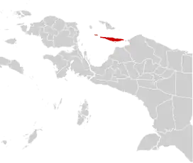 | |
 Yapen Islands Regency Location in Western New Guinea and Indonesia  Yapen Islands Regency Yapen Islands Regency (Indonesia) | |
| Coordinates: 1.7877°S 136.2772°E | |
| Country | |
| Province | |
| Capital | Serui |
| Government | |
| • Regent | Cyfrianus Yustus Mambay |
| • Vice Regent | Vacant |
| Area | |
| • Total | 2,432.49 km2 (939.19 sq mi) |
| Population (mid 2022 estimate)[1] | |
| • Total | 116,107 |
| • Density | 48/km2 (120/sq mi) |
| Time zone | UTC+9 (Indonesia Eastern Time) |
| Area code | (+62) 983 |
| Website | kepyapenkab |
Geography
The regency includes the islands and island groups of the Yapen Islands archipelago, including the main Yapen island. Its capital is Serui (part of Yapen Selatan district). The area is seismically active. A magnitude 7.5 earthquake in 1979 caused serious destruction and a tsunami, killing 115 people.[4]
Administrative Districts
The Yapen Islands Regency in 2010 comprised twelve districts (distrik); however, by 2018 four additional districts has been created (Anotaurei, Pulau Kurudu, Pulau Yerui and Yawakukat), bringing the total to sixteen, which are subdivided into 165 administrative "villages". The districts are tabulated below with their areas and their populations at the 2010 Census[2] and 2020 Census,[3] together with official estimates as at mid 2022.[1] Kurudu Island (Pulau Kurudu) lies to the east of Yapen, and Num Island (Pulau Yerui) lies to the west of Yapen, while the Ambai Islands (Kepulauan Ambai) lie immediately off the south coast of Yapen. The table also includes the name of the administrative centre of each district, the number of administrative villages in each district (160 rural kampung and 5 urban kelurahan in total) and its post code.
| Name of District (distrik) | Area in km2 | Pop'n 2010 Census | Pop'n 2020 Census | Pop'n mid 2022 Estimate | Admin centre | No. of villages | Post code |
|---|---|---|---|---|---|---|---|
| Yapen Timur (East Yapen) | 168.96 | 4,618 | 6,969 | 7,283 | Dawai | 11 | 98644 |
| Yapen Utara (North Yapen) | 386.41 | 2,304 | 2,920 | 2,951 | Tindaret | 7 | 98645 |
| Teluk Ampimoi (Ampimoi Bay) | 266.04 | 3,416 | 3,224 | 3,244 | Randawaya | 11 | 98642 |
| Raimbawi | 179.93 | 2,455 | 1,481 | 1,492 | Waindu | 7 | 98641 |
| Pulau Kurudu (Kurudu Island) | 21.49 | (a) | 1,597 | 1,589 | Kirimbri | 8 | 98643 |
| Angkaisera | 68.72 | 8,046 | 7,240 | 7,381 | Menawi | 11 | 98655 |
| Kepulauan Ambai (Ambai Islands) | 27.39 | 3,656 | 4,200 | 4,217 | Ambai | 18 | 98653 |
| Yapen Selatan (South Yapen) | 34.48 | 38,032 | 39,814 | 41,629 | Serui | 13 (b) | 98612 -98627 |
| Kosiwo | 362.79 | 3,781 | 5,391 | 5,520 | Tatui | 15 | 98632 |
| Yapen Barat (West Yapen) | 243.16 | 7,831 | 9,242 | 9,280 | Ansus | 17 (c) | 98648 |
| Wonawa | 123.72 | 3,153 | 2,916 | 2,922 | Wooi | 10 | 98647 |
| Pulau Yerui (Yerui or Num Island) | 90.06 | (d) | 827 | 830 | Miosnum | 5 | 98646 |
| Poom | 123.19 | 3,128 | 3,255 | 3,262 | Poom | 8 | 98652 |
| Windesi | 222.04 | 2,530 | 2,493 | 2,508 | Windesi | 9 | 98651 |
| Anotaurei | 23.09 | (e) | 17,683 | 18,488 | Antorei | 8 (c) | 98631 |
| Yawakukat | 90.34 | (f) | 3,436 | 3,503 | Woniwon | 7 | 98654 |
| Totals | 2,432.49 | 82,951 | 112,676 | 116,107 | 165 |
Notes:
Kepulauan Ambai District consists of 17 islands; Yapen Barat District includes 20 offshore islands, while Angkaisera District includes three offshore islands and Wonawa District includes five offshore islands.
(a) the 2010 figure for Pulau Kurudu District is included in that for Yapen Timur District, from which it was split. (b) including 3 kelurahan.
(c) including 1 kelurahan (the district centre). (d) the 2010 figure for Pulau Yerui District is included in that for Yapen Barat District, from which it was split.
(e) the 2010 figure for Aotaurei District is included in that for Yapen Selatan District, from which it was split.
(f) the 2010 figure for Yawakukat District is included in that for Angkaisera District, from which it was split.
Climate
Serui has a tropical rainforest climate (Af) with heavy rainfall year-round.
| Climate data for Serui | |||||||||||||
|---|---|---|---|---|---|---|---|---|---|---|---|---|---|
| Month | Jan | Feb | Mar | Apr | May | Jun | Jul | Aug | Sep | Oct | Nov | Dec | Year |
| Average high °C (°F) | 30.4 (86.7) |
30.3 (86.5) |
30.3 (86.5) |
30.5 (86.9) |
30.4 (86.7) |
29.8 (85.6) |
29.2 (84.6) |
29.4 (84.9) |
29.9 (85.8) |
30.3 (86.5) |
30.5 (86.9) |
30.5 (86.9) |
30.1 (86.2) |
| Daily mean °C (°F) | 26.4 (79.5) |
26.4 (79.5) |
26.4 (79.5) |
26.6 (79.9) |
26.6 (79.9) |
26.1 (79.0) |
25.6 (78.1) |
25.7 (78.3) |
26.0 (78.8) |
26.3 (79.3) |
26.5 (79.7) |
26.5 (79.7) |
26.3 (79.3) |
| Average low °C (°F) | 22.5 (72.5) |
22.5 (72.5) |
22.6 (72.7) |
22.7 (72.9) |
22.8 (73.0) |
22.5 (72.5) |
22.1 (71.8) |
22.1 (71.8) |
22.2 (72.0) |
22.4 (72.3) |
22.6 (72.7) |
22.6 (72.7) |
22.5 (72.5) |
| Average rainfall mm (inches) | 267 (10.5) |
277 (10.9) |
317 (12.5) |
217 (8.5) |
251 (9.9) |
248 (9.8) |
246 (9.7) |
279 (11.0) |
234 (9.2) |
236 (9.3) |
224 (8.8) |
286 (11.3) |
3,082 (121.4) |
| Source: Climate-Data.org[5] | |||||||||||||
See also
- Yapen Islands topics
References
- Badan Pusat Statistik, Jakarta, 2023, Kabupaten Kepulauan Yapen Dalam Angka 2023 (Katalog-BPS 1102001.9105)
- Biro Pusat Statistik, Jakarta, 2011.
- Badan Pusat Statistik, Jakarta, 2021.
- National Geophysical Data Center / World Data Service (NGDC/WDS): NCEI/WDS Global Significant Earthquake Database. NOAA National Centers for Environmental Information. "Significant Earthquake Information" (Data Set). doi:10.7289/V5TD9V7K. Retrieved 10 June 2022.
- "Climate: Serui". Climate-Data.org. Retrieved 26 November 2020.