Yekaterinoslav uezd
The Yekaterinoslav uezd (Russian: Екатеринославскій уѣздъ, romanized: Yekaterinoslavskiy uyezd; Ukrainian: Катеринославський повіт, romanized: Katerynoslavs'kyi povit) was one of the subdivisions of the Yekaterinoslav Governorate of the Russian Empire. It was situated in the western part of the governorate. Its administrative centre was Yekaterinoslav (present-day Dnipro).
Yekaterinoslav uezd
Екатеринославскій уѣздъ | |
|---|---|
 Coat of arms | |
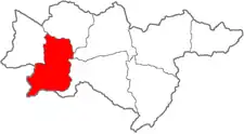 Location in the Yekaterinoslav Governorate | |
| Country | Russian Empire |
| Governorate | Yekaterinoslav |
| Established | 1783 |
| Abolished | 1920 |
| Capital | Yekaterinoslav |
| Area | |
| • Total | 7,858.31 km2 (3,034.11 sq mi) |
| Population (1897) | |
| • Total | 357,207 |
| • Density | 45/km2 (120/sq mi) |
Demographics
At the time of the Russian Empire Census of 1897, Yekaterinoslavsky Uyezd had a population of 357,207. Of these, 55.7% spoke Ukrainian, 21.0% Russian, 13.0% Yiddish, 5.8% German, 2.2% Polish, 1.1% Belarusian, 0.5% Moldovan or Romanian, 0.2% Tatar, 0.1% Czech, 0.1% French and 0.1% Greek as their native language.[1]
This article is issued from Wikipedia. The text is licensed under Creative Commons - Attribution - Sharealike. Additional terms may apply for the media files.