Yewa River
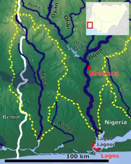
The Yewa River is a trans-boundary river between Republic of Benin and Nigeria, running along the Bight of Benin; at one point it crosses the border between the two countries.[1] Other variants of the name are Yeoua, and, with accents, Yéoua and Yéwa.[2] Its elevation is sea level.[3] The Yewa's major sources are the Atan and Ilaro rivers. The Yewa empties into Badagry Creek which empties, in turn, into Lagos Harbor.
| Yewa River Yeoua, Yéoua, Yéwa | |
|---|---|
 | |
| Location | |
| Country | Nigeria, Benin |
| Cities | Atan, Porto Novo, Ilaro, Ado-Odo, Apamu, Igunnu Akabo, Badagry |
| Physical characteristics | |
| Mouth | Atlantic Ocean |
• location | Yewa Lagoon, Nigeria |
POLLUTION
According to research, Yewa rivers alongside other rivers are known to discharge large amount of water from inland and coastal cities which is directed to Lagos lagoon. The activities that causes this pollution entails industrial, domestic and agricultural activities. These contains organic and inorganic pollutants which affects the health risks of water bodies and people who consume them.[6]
References
- "International Boundary Study, No. 91 – October 15, 1969, Benin (Dahomey) – Nigeria Boundary" (PDF). U.S. Department of State. p. 4. Archived from the original (PDF) on February 15, 2016. Retrieved February 8, 2016.
- "River Yewa stream, Nigeria". ng.geoview.info. Retrieved 2023-07-11.
- "River Yewa". Geoview.info. Archived from the original on June 28, 2021. Retrieved February 8, 2016.
- "River Yewa / River Yewa, Nigeria (general), Nigeria, Africa". travelingluck.com. Retrieved 2023-07-11.
- "River Yewa (Yewa River) - Lagos Map, Weather and Photos - Nigeria: stream - Lat:6.43333 and Long:2.85". www.getamap.net. Retrieved 2023-07-11.
- Adeogun, Aina; Conversation, The. "How we learned more about dangerous pollutants in Lagos lagoon". phys.org. Retrieved 2023-09-26.