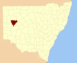
Young County, New South Wales

Young County is one of the 141 Cadastral divisions of New South Wales. It includes the area to the west of Wilcannia. The Darling River is the south-eastern boundary.

Young
New South Wales
Location in New South Wales
Lands administrative divisions around Young:
Mootwingee Yungnulgra Killara
Mootwingee Young Werunda
Tandora Livingstone Livingstone

Young County was named in honour of the twelfth Governor of New South Wales, Sir John Young, First Baron Lisgar (1807-1876).[1]

Parishes within this county

A full list of parishes found within this county; their current LGA and mapping coordinates to the approximate centre of each location is as follows:

ParishLGACoordinates
ArdennesUnincorporated31°24′20″S 142°38′27″E
BarbstonCentral Darling Shire31°11′21″S 143°02′42″E
BaroorangeeUnincorporated31°13′50″S 142°28′52″E
BlancheUnincorporated31°13′56″S 142°35′44″E
BlumenthalCentral Darling Shire31°31′12″S 143°07′00″E
BonleyCentral Darling Shire31°49′31″S 143°05′13″E
BroughamCentral Darling Shire31°27′37″S 143°13′52″E
BroughtonUnincorporated31°38′06″S 142°39′29″E
BungarooUnincorporated31°30′37″S 142°31′49″E
CameronCentral Darling Shire31°18′36″S 143°13′05″E
ClaytonUnincorporated31°38′42″S 142°45′23″E
CobrillaCentral Darling Shire
ComartoCentral Darling Shire31°25′18″S 142°46′55″E
CoregaCentral Darling Shire32°03′16″S 142°55′10″E
CoromerryCentral Darling Shire31°38′59″S 143°17′48″E
CulpaulinCentral Darling Shire
CuthowaraUnincorporated31°35′39″S 142°45′22″E
DalglishCentral Darling Shire31°41′22″S 142°52′10″E
DarlingCentral Darling Shire31°22′10″S 143°19′26″E
DaubenyUnincorporated31°16′07″S 142°41′50″E
DesaillyCentral Darling Shire31°34′39″S 143°12′57″E
DickensCentral Darling Shire31°30′32″S 143°00′26″E
Dry LakeCentral Darling Shire31°24′59″S 143°12′40″E
EvelynCentral Darling Shire31°21′01″S 143°25′14″E
GarlandCentral Darling Shire31°38′55″S 143°11′50″E
GoodeCentral Darling Shire31°09′32″S 143°29′01″E
GrevilleUnincorporated31°33′09″S 142°39′27″E
GriffithsUnincorporated31°18′46″S 142°39′49″E
JenningsCentral Darling Shire31°34′33″S 142°52′41″E
KambulaCentral Darling Shire31°16′32″S 143°32′44″E
KingCentral Darling Shire31°49′01″S 142°58′29″E
KopagoCentral Darling Shire31°14′39″S 143°26′55″E
LoftusUnincorporated31°23′26″S 142°29′20″E
MackenzieCentral Darling Shire31°44′12″S 143°00′07″E
MitchellCentral Darling Shire31°23′22″S 142°54′12″E
MoorabinCentral Darling Shire31°29′51″S 143°29′48″E
MoorguinniaCentral Darling Shire31°16′52″S 142°55′04″E
MorrisetCentral Darling Shire31°29′47″S 142°53′19″E
MulgaCentral Darling Shire31°42′58″S 143°07′52″E
MulyeneryCentral Darling Shire31°54′05″S 142°57′12″E
MurchisonCentral Darling Shire31°24′02″S 143°19′25″E
NetallieCentral Darling Shire31°41′00″S 143°15′48″E
ParadiseCentral Darling Shire31°50′58″S 142°44′14″E
ParkesCentral Darling Shire31°46′03″S 142°51′34″E
PeverilCentral Darling Shire31°13′04″S 142°48′38″E
RobinsonCentral Darling Shire31°37′07″S 142°59′33″E
SutherlandCentral Darling Shire31°36′00″S 143°06′22″E
TallandraCentral Darling Shire31°24′11″S 143°40′25″E
UltimoCentral Darling Shire31°52′57″S 142°51′11″E
WaltragaldaCentral Darling Shire31°26′19″S 143°24′40″E
WilcanniaCentral Darling Shire31°29′02″S 143°21′22″E
WillisCentral Darling Shire31°39′36″S 143°00′43″E
WoodCentral Darling Shire31°18′03″S 143°06′52″E
WooreCentral Darling Shire31°21′05″S 143°32′56″E
WoorungilUnincorporated31°46′14″S 142°37′33″E
WoytchuggaCentral Darling Shire
YoungCentral Darling Shire31°21′09″S 142°47′12″E
YungnulgraCentral Darling Shire31°23′38″S 143°00′38″E

References

  1. "Young". Geographical Names Register (GNR) of NSW. Geographical Names Board of New South Wales. Retrieved 11 August 2013.
This article is issued from Wikipedia. The text is licensed under Creative Commons - Attribution - Sharealike. Additional terms may apply for the media files.