Zabul Province
Zabul (Pashto/Dari: زابل) is one of the 34 provinces of Afghanistan, located in the south of the country. It has a population of 249,000.[4] Zabul became an independent province from neighbouring Kandahar in 1963. Historically, it was part of the Zabulistan region. Qalat serves as the capital of the province. The major ethnic group are Pashtuns. Primary occupations within Zabul are agriculture and animal husbandry.
Zabul
زابل | |
|---|---|
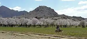 Almond trees in Zabul Province | |
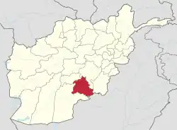 Map of Afghanistan with Zabul highlighted | |
| Coordinates: 32.1°N 67.1°E | |
| Country | |
| Capital | Qalat |
| Government | |
| • Governor | Mullah Bismillah Abdullah[1] |
| • Deputy Governor | Abdul Khaliq Abid[1] |
| Area | |
| • Total | 17,343 km2 (6,696 sq mi) |
| Population (2021)[4] | |
| • Total | 391,150 |
| • Density | 23/km2 (58/sq mi) |
| Time zone | UTC+4:30 (Afghanistan Time) |
| ISO 3166 code | AF-ZAB |
| Main languages | Pashto |
Geography

Zabul borders Oruzgan in the north, Kandahar in the west and in the south, Ghazni and Paktika in the east. It borders Pakistan in the east.
The province covers an area of 17293 km2. Two-fifths of the province is mountainous or semi mountainous terrain (41%) while more than one quarter of the area is made up of flat land (28%).
The primary ecoregion of the province is the central Afghan mountains xeric woodlands. Common vegetation is listed as dry shrub-land and pistachio. The high mountains of the northern portion of the province are in the Ghor-Hazarajat alpine meadow ecoregion, which is characterized by meadows, willows, and sea buckthorn.[5]
Transportation
In 2006, the province's first airstrip was opened near Qalat, to be operated by the Afghan National Army, but also for use by commercial aviation. Twice weekly service was scheduled by PRT Air between Qalat and Kabul. The airstrip is not paved.[6] The ANA Chief in Zabul is Major General Jamaluddin Sayed[7]
Zabul Province is bisected by Highway 1 and travelers going between Kandahar and Kabul via road typically pass through the province.[8]
On 4 September 2016, at least 38 people were killed and 28 were injured during the September 2016 Afghanistan road crash.
Healthcare
The percentage of households with clean drinking water increased from 0% in 2005 to 32% in 2011. The percentage of births attended to by a skilled birth attendant increased from 1% in 2005 to 5% in 2011.
Education
The overall literacy rate (6+ years of age) increased from 1% in 2005 to 19% in 2011. The overall net enrollment rate (6–13 years of age) fell from 31.3% in 2005 to 5% in 2011.
Demographics

As of 2021, the total population of the province is about 391,150,[4] which is mostly a rural tribal society. According to the Naval Postgraduate School, the population is primarily Pashtun, sprinkled throughout around 2,500 remote villages. Major tribal groups include the Tokhi and Hotaki Ghilji and the Noorzai and Panjpai Durrani.
Pashto is the dominant language in the area. The people of Zabul are overwhelmingly Sunni Muslim. Primary occupations within Zabul are agriculture and animal husbandry.[9]
60.8% of the population lived below the national poverty line, one of the highest figures of all of Afghanistan's provinces.[10]
Zabul is by many indications one of Afghanistan's most conservative provinces.[11]
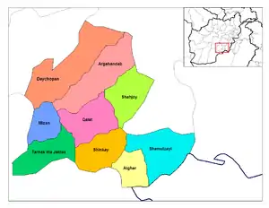
Districts
| District | Capital | Population (2021)[4] | Area | Notes |
|---|---|---|---|---|
| Arghandab | 37,580 | 100% Pashtun.[12] Sub-divided in 2005 | ||
| Atghar | 14,305 | 100% Pashtun.[13] | ||
| Daychopan | 45,285 | 100% Pashtun.[14] | ||
| Kakar | 27,710 | 99% Pashtun, 1% Hazara.[15] Created in 2005 within Arghandab District Also known as Khak-e-Afghan Province. | ||
| Mezana | 22,001 | 100% Pashtun.[16] | ||
| Naw Bahar | 24,962 | 100% Pashtun.[17] Created in 2005 from parts of Shamulzayi and Shinkay Districts | ||
| Qalat | Qalat | 45,798 | 95% Pashtun, 5% Tajik.[18] | |
| Shah Joy | 81,285 | 100% Pashtun.[19] | ||
| Shamulzayi | 37,152 | 100% Pashtun.[20] | ||
| Shinkay | 32,469 | 100% Pashtun.[21] | ||
| Tarnak Aw Jaldak | 22,603 | 100% Pashtun.[22] |
Sports
The province is represented in Afghan domestic cricket by the Zabul Province cricket team.
Gallery
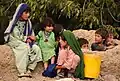 Children in Arghandab
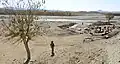 A bridge on the Kabul–Kandahar Highway
Notable people
References
- "د نږدې شلو ولایاتو لپاره نوي والیان او امنیې قوماندانان وټاکل شول". 7 November 2021.
- Provinces of Afghanistan on Statoids.
- "Afghanistan's Provinces – Zabul at USAID". usaid.gov. Retrieved 2 April 2018.
- "Estimated Population of Afghanistan 2021-22" (PDF). National Statistic and Information Authority (NSIA). April 2021. Archived (PDF) from the original on June 24, 2021. Retrieved June 21, 2021.
- World Wildlife Fund, ed. (2001). "Central Afghan Mountains xeric woodlands". WildWorld Ecoregion Profile. National Geographic Society. Archived from the original on 2010-03-08.
- First Airstrip in Zabul Province, USAID
- Online, Asia Time. "Asia Times Online :: South Asia news, business and economy from India and Pakistan". www.atimes.com. Archived from the original on 3 December 2009. Retrieved 2 April 2018.
{{cite web}}: CS1 maint: unfit URL (link) - "The Back of Beyond: A Report from Zabul Province". worldaffairsjournal.org. Archived from the original on September 8, 2012. Retrieved 2 April 2018.
{{cite web}}: CS1 maint: unfit URL (link) - "Zabul Province". Program for Culture & Conflict Studies. Naval Postgraduate School. Retrieved 2013-06-16.
- Giustozzi, Antonio (August 2012). Decoding the New Taliban: Insights from the Afghan Field. Hurst. ISBN 9781849042260.
- "Conservative of Zabul Province" (PDF). reliefweb.int. Retrieved 17 Dec 2022.
- "UNHCR Sub-Office Kandahar - DISTRICT PROFILE Arghandab" (PDF). Archived from the original (PDF) on 2005-10-27.
- "UNHCR Sub-Office Kandahar - DISTRICT PROFILE Atghar" (PDF). Archived from the original (PDF) on 2005-10-27.
- "UNHCR Sub-Office Kandahar - DISTRICT PROFILE Daychopan" (PDF). Archived from the original (PDF) on 2005-10-27.
- "UNHCR Sub-Office Kandahar - DISTRICT PROFILE Kakar" (PDF). Archived from the original (PDF) on 2005-10-27.
- "UNHCR Sub-Office Kandahar - DISTRICT PROFILE Mezana" (PDF). Archived from the original (PDF) on 2005-10-27.
- "UNHCR Sub-Office Kandahar - DISTRICT PROFILE Naw Bahar" (PDF). Archived from the original (PDF) on 2005-10-27.
- "UNHCR Sub-Office Kandahar - DISTRICT PROFILE Qalat" (PDF). Archived from the original (PDF) on 2005-10-27.
- "UNHCR Sub-Office Kandahar - DISTRICT PROFILE Shah Joy" (PDF). Archived from the original (PDF) on 2005-10-27.
- "UNHCR Sub-Office Kandahar - DISTRICT PROFILE Shamulzayi" (PDF). Archived from the original (PDF) on 2005-10-27.
- "UNHCR Sub-Office Kandahar - DISTRICT PROFILE Shinkay" (PDF). Archived from the original (PDF) on 2005-10-27.
- "UNHCR Sub-Office Kandahar - DISTRICT PROFILE Tarnak Aw Jaldak" (PDF). Archived from the original (PDF) on 2005-10-27.
External links
Places adjacent to Zabul Province | ||||||||||||||||
|---|---|---|---|---|---|---|---|---|---|---|---|---|---|---|---|---|
| ||||||||||||||||
| Districts | | |
|---|---|---|
| Populated places | ||
| Other | ||