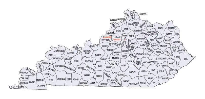
List of counties in Kentucky
There are 120 counties in the U.S. Commonwealth of Kentucky. Despite ranking 37th in size by area, Kentucky has 120 counties, fourth among states (including Virginia's independent cities).[1] The original motivation for having so many counties was to ensure that residents in the days of poor roads and horseback travel could make a round trip from their home to the county seat in a single day, as well as being able to travel from one county seat to the next in the same fashion. Later, however, politics began to play a part, with citizens who disagreed with their county government petitioning the state to create a new county.[2] Today, 21 of the 120 counties have fewer than 10,000 residents, and half have fewer than 20,000. The 20 largest counties by population all have populations of 48,000 or higher, and just 7 of the 120 have a population of 100,000 or higher. The average county population, based on the estimated 2021 state population of 4.509 million, was 37,578.
| Counties of Kentucky | |
|---|---|
 | |
| Location | Commonwealth of Kentucky |
| Number | 120 |
| Populations | 2,257 (Robertson) – 777,874 (Jefferson) |
| Areas | 100 square miles (260 km2) (Robertson) – 788 square miles (2,040 km2) (Pike) |
| Government | |
Following concerns of too many counties,[2] the 1891 Kentucky Constitution placed stricter limits on county creation, stipulating that a new county:
- must have a land area of at least 400 square miles (1,036 km2);
- must have a population of at least 12,000 people;
- must not by its creation reduce the land area of an existing county to less than 400 square miles;
- must not by its creation reduce the population of an existing county to fewer than 12,000 people;
- must not create a county boundary line that passes within 10 miles (16 kilometers) of an existing county seat.
These regulations have reined in the proliferation of counties in Kentucky. Since the 1891 Constitution, only McCreary County has been legally created, in 1912. The General Assembly's creation of Beckham County in 1904 was ruled unconstitutional.[3] Because today's largest county by area, Pike County, is 788 square miles (2,041 km2), it is only still possible to form a new county from portions of more than one existing county; McCreary County was formed in this manner, from parts of Wayne, Pulaski and Whitley counties.
Kentucky was originally a single county in Virginia, created in 1776. In 1780, Kentucky County was divided into Fayette, Jefferson, and Lincoln counties. Kentucky was admitted as a state in 1792, when it had nine counties.[4]
Each county has a legislative council called the fiscal court;[5] despite the name, it no longer has any responsibility for judicial proceedings.[6] The county judge/executive, the head of government of the county, is an ex officio member of the fiscal court and its presiding officer. Constitutionally, the fiscal court may either be composed of the magistrates for the county or of three commissioners elected from the county at large.[5][7]
The largest city in Kentucky, Louisville, is a consolidated local government under KRS 67C. When the Louisville Metro government was formed, all incorporated cities in Jefferson County, apart from Louisville, retained their status as cities; however, the Louisville Metro Council is the main government for the entire county, and is elected by residents in all of Jefferson County. [7] The second largest, Lexington, is an urban-county government under KRS 67A. Lexington and Fayette County are completely merged and there are no separate incorporated cities within the county.[7] In both of these counties, while Lexington and Louisville city governments govern their respective counties, a county judge/executive is still elected, as required by Kentucky's Constitution, but does not have substantive powers.[7][8]
The Federal Information Processing Standard (FIPS) code, which is used by the United States government to uniquely identify counties, is provided with each entry; for Kentucky, the codes start with 21 and are completed with the three digit county code. The FIPS code for each county links to census data for that county.
Counties
| County |
FIPS code | County seat[9] | Est.[9] | Formed from[10] | Etymology[2] | Population (2021)[11] | Area[9] | Map |
|---|---|---|---|---|---|---|---|---|
| Adair County | 001 | Columbia | 1802 | Green County | John Adair, eighth Governor of Kentucky (1820–24) | 18,932 | 407 sq mi (1,054 km2) | 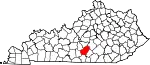 |
| Allen County | 003 | Scottsville | 1815 | Barren County and Warren County | John Allen (1771–1813), hero of the Battle of Frenchtown in the War of 1812 | 20,797 | 346 sq mi (896 km2) | 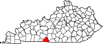 |
| Anderson County | 005 | Lawrenceburg | 1827 | Franklin County, Washington County and Mercer County | Richard Clough Anderson, Jr., Kentucky and United States legislator (1817–21) | 24,035 | 203 sq mi (526 km2) | 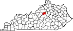 |
| Ballard County | 007 | Wickliffe | 1842 | Hickman County and McCracken County | Bland Ballard (1761–1853), hero of the Battle of Fallen Timbers and Battle of River Raisin | 7,695 | 251 sq mi (650 km2) | 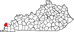 |
| Barren County | 009 | Glasgow | 1798 | Green County and Warren County | The Barrens, a region of grassland in Kentucky | 44,544 | 491 sq mi (1,272 km2) | 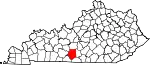 |
| Bath County | 011 | Owingsville | 1811 | Montgomery County | Medicinal springs located within the county | 12,778 | 279 sq mi (723 km2) | 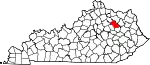 |
| Bell County | 013 | Pineville | 1867 | Harlan County and Knox County | Joshua Fry Bell, Kentucky legislator (1862–67) | 23,858 | 361 sq mi (935 km2) | 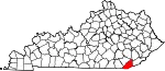 |
| Boone County | 015 | Burlington | 1798 | Campbell County | Daniel Boone (1734–1820), frontiersman | 137,412 | 246 sq mi (637 km2) | 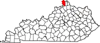 |
| Bourbon County | 017 | Paris | 1785 | Fayette County | House of Bourbon, European royal house | 20,229 | 291 sq mi (754 km2) | 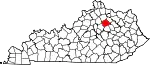 |
| Boyd County | 019 | Catlettsburg | 1860 | Greenup County, Carter County and Lawrence County | Linn Boyd, United States Congressman (1835–37; 1839–55) and Lieutenant Governor of Kentucky (1859) | 47,899 | 160 sq mi (414 km2) | 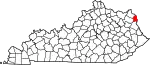 |
| Boyle County | 021 | Danville | 1842 | Lincoln County and Mercer County | John Boyle, Chief Justice of the Kentucky Court of Appeals (1810–26) | 30,747 | 182 sq mi (471 km2) | 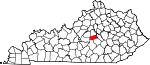 |
| Bracken County | 023 | Brooksville | 1796 | Mason County and Campbell County | William Bracken, trapper and frontiersman | 8,439 | 203 sq mi (526 km2) | 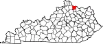 |
| Breathitt County | 025 | Jackson | 1839 | Clay County, Perry County and Estill County | John Breathitt, eleventh Governor of Kentucky (1832–34) | 13,553 | 495 sq mi (1,282 km2) | 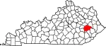 |
| Breckinridge County | 027 | Hardinsburg | 1799 | Hardin County | John Breckinridge (1760–1806), Kentucky statesman and U.S. Senator | 20,651 | 572 sq mi (1,481 km2) | 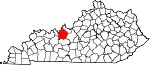 |
| Bullitt County | 029 | Shepherdsville | 1796 | Jefferson County and Nelson County | Alexander Scott Bullitt, Lieutenant Governor of Kentucky (1800–04) | 82,918 | 299 sq mi (774 km2) | 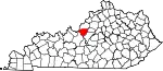 |
| Butler County | 031 | Morgantown | 1810 | Logan County and Ohio County | Richard Butler (1743–91), Revolutionary War general | 12,294 | 428 sq mi (1,109 km2) | 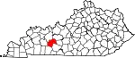 |
| Caldwell County | 033 | Princeton | 1809 | Livingston County | John Caldwell, Lieutenant Governor of Kentucky (1804) | 12,624 | 347 sq mi (899 km2) | 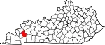 |
| Calloway County | 035 | Murray | 1822 | Hickman County | Richard Callaway (1724–80), pioneer | 37,560 | 386 sq mi (1,000 km2) | 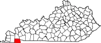 |
| Campbell County | 037 | Alexandria and Newport | 1794 | Harrison County, Mason County and Scott County | John Campbell (1735–99), Revolutionary War colonel | 93,050 | 152 sq mi (394 km2) | 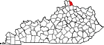 |
| Carlisle County | 039 | Bardwell | 1886 | Hickman County | John G. Carlisle, United States legislator (1877–89) and Speaker of the U.S. House of Representatives | 4,791 | 192 sq mi (497 km2) | 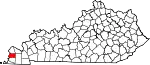 |
| Carroll County | 041 | Carrollton | 1838 | Gallatin County, Trimble County, and Henry county | Charles Carroll (1737–1832), last living signer of the Declaration of Independence | 10,863 | 130 sq mi (337 km2) | 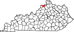 |
| Carter County | 043 | Grayson | 1838 | Greenup County and Lawrence County | William Grayson Carter, Kentucky state senator (1834–38) | 26,412 | 411 sq mi (1,064 km2) | 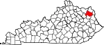 |
| Casey County | 045 | Liberty | 1806 | Lincoln County | William Casey (1754–1816), Revolutionary War colonel | 15,866 | 446 sq mi (1,155 km2) | 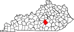 |
| Christian County | 047 | Hopkinsville | 1796 | Logan County | William Christian (1743–86), Revolutionary War soldier and founder of Louisville, Kentucky | 72,357 | 721 sq mi (1,867 km2) | 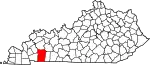 |
| Clark County | 049 | Winchester | 1792 | Bourbon County and Fayette County | George Rogers Clark (1752–1818), Revolutionary War general | 36,871 | 254 sq mi (658 km2) | 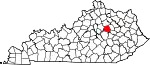 |
| Clay County | 051 | Manchester | 1807 | Madison County, Floyd County, and Knox County | Green Clay (1757–1828), Revolutionary War general and western surveyor | 20,206 | 471 sq mi (1,220 km2) | 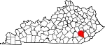 |
| Clinton County | 053 | Albany | 1835 | Cumberland County and Wayne County | DeWitt Clinton, Governor of New York (1817–23) | 9,265 | 198 sq mi (513 km2) | 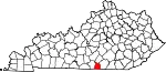 |
| Crittenden County | 055 | Marion | 1842 | Livingston County | John Jordan Crittenden, seventeenth Governor of Kentucky (1848–50) | 8,947 | 362 sq mi (938 km2) | 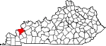 |
| Cumberland County | 057 | Burkesville | 1798 | Green County | The Cumberland River, which flows through the county | 5,879 | 306 sq mi (793 km2) | 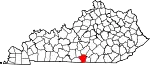 |
| Daviess County | 059 | Owensboro | 1815 | Ohio County | Joseph Hamilton Daveiss (1774–1811), lawyer killed at the Battle of Tippecanoe | 103,063 | 462 sq mi (1,197 km2) | 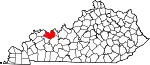 |
| Edmonson County | 061 | Brownsville | 1825 | Hart County, Grayson County, and Warren County | John Edmonson (1764–1813), military captain killed at the Battle of Frenchtown | 12,291 | 303 sq mi (785 km2) | 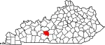 |
| Elliott County | 063 | Sandy Hook | 1869 | Morgan County, Lawrence County, and Carter County | John Milton Elliott (1820–85), U.S. Representative from Kentucky | 7,381 | 234 sq mi (606 km2) | 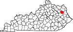 |
| Estill County | 065 | Irvine | 1808 | Clark County and Madison County | James Estill (1750–82), military captain killed at the Battle of Little Mountain | 14,092 | 254 sq mi (658 km2) | 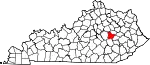 |
| Fayette County | 067 | Lexington | 1780 | Kentucky County | Gilbert du Motier, marquis de Lafayette (1757–1834), French-born Revolutionary War general | 321,793 | 284 sq mi (736 km2) | 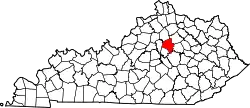 |
| Fleming County | 069 | Flemingsburg | 1798 | Mason County | John Fleming (1735–91), frontiersman and one of the county's original settlers | 15,224 | 351 sq mi (909 km2) | 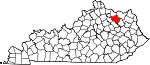 |
| Floyd County | 071 | Prestonsburg | 1800 | Fleming County, Montgomery County, and Mason County | John Floyd (1750–83), surveyor and pioneer | 35,274 | 394 sq mi (1,020 km2) | 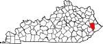 |
| Franklin County | 073 | Frankfort | 1794 | Mercer County, Shelby County, and Woodford County | Benjamin Franklin (1706–90), signer of the Declaration of Independence and U.S. Founding Father | 51,682 | 210 sq mi (544 km2) | 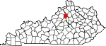 |
| Fulton County | 075 | Hickman | 1845 | Hickman County | Robert Fulton (1765–1815), inventor of the first commercially successful steamboat | 6,512 | 209 sq mi (541 km2) | 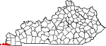 |
| Gallatin County | 077 | Warsaw | 1798 | Franklin County and Shelby County | Albert Gallatin, United States Secretary of the Treasury (1801–14) | 8,775 | 105 sq mi (272 km2) | 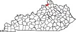 |
| Garrard County | 079 | Lancaster | 1796 | Madison County, Lincoln County, and Mercer County | James Garrard, second Governor of Kentucky (1796–1804) | 17,362 | 231 sq mi (598 km2) | 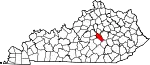 |
| Grant County | 081 | Williamstown | 1820 | Pendleton County | Samuel Grant (1762–89 or 94), John Grant (1754–1826), and Squire Grant (1764–1833), three of the county's earliest settlers | 25,244 | 260 sq mi (673 km2) | 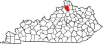 |
| Graves County | 083 | Mayfield | 1824 | Hickman County | Benjamin F. Graves (1771–1813), army major killed at the Battle of Frenchtown | 36,615 | 556 sq mi (1,440 km2) | 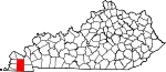 |
| Grayson County | 085 | Leitchfield | 1810 | Hardin County and Ohio County | William Grayson (1740–90), aide to George Washington in the Revolutionary War and U.S. Senator from Virginia | 26,524 | 504 sq mi (1,305 km2) | 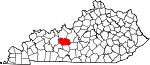 |
| Green County | 087 | Greensburg | 1792 | Lincoln County and Nelson County | Nathanael Greene (1742–86), Revolutionary War general | 11,291 | 289 sq mi (749 km2) | 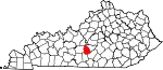 |
| Greenup County | 089 | Greenup | 1803 | Mason County | Christopher Greenup, third Governor of Kentucky (1804–08) | 35,649 | 346 sq mi (896 km2) | 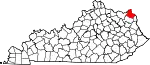 |
| Hancock County | 091 | Hawesville | 1829 | Ohio County, Breckinridge County, and Daviess County | John Hancock (1737–93), signer of the Declaration of Independence | 9,064 | 189 sq mi (490 km2) | 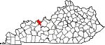 |
| Hardin County | 093 | Elizabethtown | 1792 | Nelson County | John Hardin (1753–92), pioneer | 111,607 | 628 sq mi (1,627 km2) | 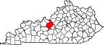 |
| Harlan County | 095 | Harlan | 1819 | Knox County | Silas Harlan (1753–82), army major in the Battle of Blue Licks | 26,164 | 467 sq mi (1,210 km2) | 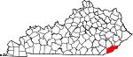 |
| Harrison County | 097 | Cynthiana | 1793 | Bourbon County and Scott County | Benjamin Harrison (1726–91), co-author of the Kentucky Constitution | 18,950 | 310 sq mi (803 km2) | 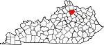 |
| Hart County | 099 | Munfordville | 1819 | Hardin County and Barren County | Nathaniel G. S. Hart (1784–1813), army major and lawyer captured at the Battle of Frenchtown | 19,460 | 416 sq mi (1,077 km2) | 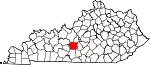 |
| Henderson County | 101 | Henderson | 1798 | Christian County | Richard Henderson (1734–85), founder of the Transylvania Company | 44,329 | 440 sq mi (1,140 km2) | 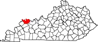 |
| Henry County | 103 | New Castle | 1798 | Shelby County | Patrick Henry (1736–99), Revolutionary War-era legislator and U.S. founding father | 15,657 | 289 sq mi (749 km2) | 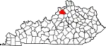 |
| Hickman County | 105 | Clinton | 1821 | Christian County | Paschal Hickman, military captain killed at the Battle of Frenchtown | 4,424 | 244 sq mi (632 km2) |  |
| Hopkins County | 107 | Madisonville | 1806 | Henderson County | Samuel Hopkins (1753–1819), Revolutionary War general | 45,138 | 551 sq mi (1,427 km2) |  |
| Jackson County | 109 | McKee | 1858 | Madison County, Estill County, Owsley County, Clay County, Laurel County, and Rockcastle County | Andrew Jackson, President of the United States (1829–37) | 12,984 | 346 sq mi (896 km2) |  |
| Jefferson County | 111 | Louisville | 1780 | Kentucky County | Thomas Jefferson, President of the United States (1801–09) | 777,874 | 385 sq mi (997 km2) | 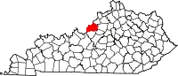 |
| Jessamine County | 113 | Nicholasville | 1798 | Fayette County | Jessamine Creek, which contains a set of rapids that are the county's most well known natural feature | 53,626 | 173 sq mi (448 km2) | 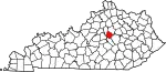 |
| Johnson County | 115 | Paintsville | 1843 | Floyd County, Lawrence County, and Morgan County | Richard Mentor Johnson, Vice President of the United States (1837–41) | 22,556 | 262 sq mi (679 km2) | 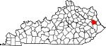 |
| Kenton County | 117 | Covington and Independence | 1840 | Campbell County | Simon Kenton (1755–1836), pioneer | 169,495 | 163 sq mi (422 km2) | 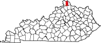 |
| Knott County | 119 | Hindman | 1884 | Perry County, Letcher County, Floyd County, and Breathitt County | James Proctor Knott, twenty-ninth Governor of Kentucky (1883–87) | 14,053 | 352 sq mi (912 km2) | 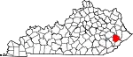 |
| Knox County | 121 | Barbourville | 1799 | Lincoln County | Henry Knox, United States Secretary of War (1785–94) | 29,909 | 388 sq mi (1,005 km2) | 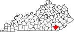 |
| LaRue County | 123 | Hodgenville | 1843 | Hardin County | John LaRue (1746–92), one of the county's original settlers and the grandfather of Governor John L. Helm | 15,028 | 263 sq mi (681 km2) | 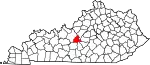 |
| Laurel County | 125 | London | 1825 | Rockcastle County, Clay County, Knox County and Whitley County | Mountain laurel trees that are prominent in the area | 62,561 | 436 sq mi (1,129 km2) | 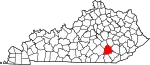 |
| Lawrence County | 127 | Louisa | 1821 | Greenup County and Floyd County | James Lawrence (1781–1813), naval commander during the War of 1812 | 16,290 | 419 sq mi (1,085 km2) | 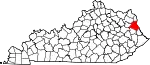 |
| Lee County | 129 | Beattyville | 1870 | Breathitt County, Estill County, Owsley County, and Wolfe County | Henry "Light Horse Harry" Lee, Revolutionary War hero and Governor of Virginia | 7,451 | 210 sq mi (544 km2) | 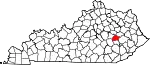 |
| Leslie County | 131 | Hyden | 1878 | Clay County, Harlan County and Perry County | Preston Leslie, twenty-sixth Governor of Kentucky (1871–75) | 10,278 | 404 sq mi (1,046 km2) | 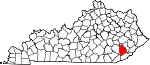 |
| Letcher County | 133 | Whitesburg | 1842 | Perry County and Harlan County | Robert P. Letcher, fifteenth Governor of Kentucky (1840–44) | 21,253 | 339 sq mi (878 km2) | 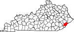 |
| Lewis County | 135 | Vanceburg | 1806 | Mason County | Meriwether Lewis (1774–1809), explorer | 12,987 | 484 sq mi (1,254 km2) | 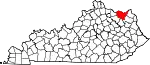 |
| Lincoln County | 137 | Stanford | 1780 | Kentucky County | Benjamin Lincoln (1733–1810), Revolutionary War general | 24,243 | 337 sq mi (873 km2) | 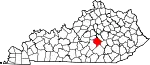 |
| Livingston County | 139 | Smithland | 1799 | Christian County | Robert Livingston (1746–1813), one of the Committee of Five that drafted the Declaration of Independence | 8,959 | 316 sq mi (818 km2) | 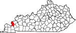 |
| Logan County | 141 | Russellville | 1792 | Lincoln County | Benjamin Logan (1742–1802), Revolutionary War general | 27,771 | 556 sq mi (1,440 km2) | 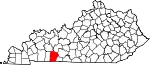 |
| Lyon County | 143 | Eddyville | 1854 | Caldwell County | Chittenden Lyon, United States Representative from Kentucky (1827–35) | 8,803 | 216 sq mi (559 km2) | 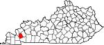 |
| McCracken County | 145 | Paducah | 1825 | Hickman County | Virgil McCracken, military captain killed at the Battle of Frenchtown | 67,454 | 251 sq mi (650 km2) | 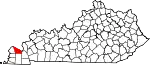 |
| McCreary County | 147 | Whitley City | 1912 | Pulaski County, Wayne County, Whitley County | James McCreary, thirty-seventh Governor of Kentucky (1912–16) | 16,892 | 428 sq mi (1,109 km2) | 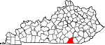 |
| McLean County | 149 | Calhoun | 1854 | Daviess County, Muhlenberg County and Ohio County | Alney McLean (1815–17; 1819–21), United States Representative from Kentucky | 9,100 | 254 sq mi (658 km2) | 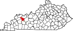 |
| Madison County | 151 | Richmond | 1785 | Lincoln County | James Madison, President of the United States (1809–17) | 94,666 | 441 sq mi (1,142 km2) | 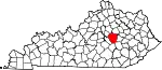 |
| Magoffin County | 153 | Salyersville | 1860 | Floyd County, Johnson County and Morgan County | Beriah Magoffin, twenty-first Governor of Kentucky (1859–62) | 11,497 | 310 sq mi (803 km2) | 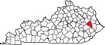 |
| Marion County | 155 | Lebanon | 1834 | Washington County | Francis Marion (1732–95), Revolutionary War general | 19,725 | 347 sq mi (899 km2) | 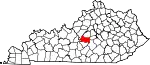 |
| Marshall County | 157 | Benton | 1842 | Calloway County | John Marshall, Chief Justice of the United States Supreme Court (1801–35) | 31,748 | 305 sq mi (790 km2) | 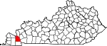 |
| Martin County | 159 | Inez | 1870 | Floyd County, Johnson County, Pike County, and Lawrence County | John P. Martin, United States Congressman from Kentucky (1845–47) | 11,140 | 231 sq mi (598 km2) | 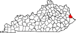 |
| Mason County | 161 | Maysville | 1788 | Bourbon County | George Mason (1725–92), statesman known as the "Father of the Bill of Rights" | 16,931 | 241 sq mi (624 km2) | 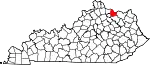 |
| Meade County | 163 | Brandenburg | 1823 | Breckinridge County and Hardin County | James Meade, military captain killed at the Battle of Frenchtown | 30,131 | 308 sq mi (798 km2) | 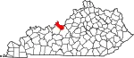 |
| Menifee County | 165 | Frenchburg | 1869 | Bath County, Montgomery County, Morgan County, Powell County and Wolfe County | Richard H. Menefee, United States Congressman from Kentucky (1837–39) | 6,194 | 204 sq mi (528 km2) | 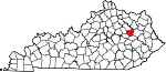 |
| Mercer County | 167 | Harrodsburg | 1785 | Lincoln County | Hugh Mercer (1726–77), Revolutionary War hero who was killed at the Battle of Princeton | 22,850 | 251 sq mi (650 km2) | 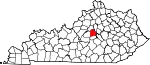 |
| Metcalfe County | 169 | Edmonton | 1860 | Barren County, Hart County, Green County, Adair County, Cumberland County and Monroe County | Thomas Metcalfe, tenth Governor of Kentucky (1828–32) | 10,349 | 291 sq mi (754 km2) | 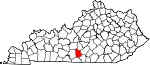 |
| Monroe County | 171 | Tompkinsville | 1820 | Barren County and Cumberland County | James Monroe, President of the United States (1817–25) | 11,233 | 331 sq mi (857 km2) | 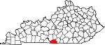 |
| Montgomery County | 173 | Mount Sterling | 1796 | Clark County | Richard Montgomery (1736–75), military general killed at the Battle of Quebec | 28,219 | 199 sq mi (515 km2) | 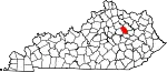 |
| Morgan County | 175 | West Liberty | 1822 | Bath County and Floyd County | Daniel Morgan (1736–1802), Revolutionary War general | 13,820 | 381 sq mi (987 km2) | 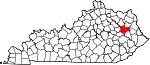 |
| Muhlenberg County | 177 | Greenville | 1798 | Christian County and Logan County | Peter Muhlenberg (1746–1807), Revolutionary War general | 30,694 | 475 sq mi (1,230 km2) | 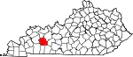 |
| Nelson County | 179 | Bardstown | 1784 | Jefferson County | Thomas Nelson, Jr. (1738–89), signer of the Declaration of Independence | 47,098 | 423 sq mi (1,096 km2) | 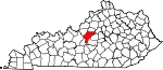 |
| Nicholas County | 181 | Carlisle | 1799 | Mason County and Bourbon County | George Nicholas (1743–99), Revolutionary War colonel | 7,712 | 197 sq mi (510 km2) | 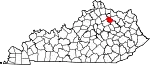 |
| Ohio County | 183 | Hartford | 1798 | Hardin County | The Ohio River, which formed the county's northern border until the creation of Daviess and Hancock counties | 23,688 | 594 sq mi (1,538 km2) | 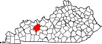 |
| Oldham County | 185 | La Grange | 1823 | Henry County, Jefferson County and Shelby County | William Oldham (1753–91), Revolutionary War colonel | 68,685 | 189 sq mi (490 km2) | 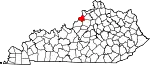 |
| Owen County | 187 | Owenton | 1819 | Franklin County, Gallatin County and Scott County | Abraham Owen (1769–1811), killed at the Battle of Tippecanoe | 11,294 | 352 sq mi (912 km2) | 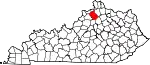 |
| Owsley County | 189 | Booneville | 1843 | Breathitt County, Clay County, and Estill County | William Owsley, Kentucky Secretary of State and later Governor of Kentucky (1844–48) | 3,953 | 198 sq mi (513 km2) |  |
| Pendleton County | 191 | Falmouth | 1798 | Campbell County and Bracken County | Edmund Pendleton (1721–1803), member of the Continental Congress | 14,607 | 280 sq mi (725 km2) | 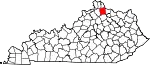 |
| Perry County | 193 | Hazard | 1820 | Floyd County and Clay County | Oliver Hazard Perry (1785–1819), Admiral in the War of 1812 | 27,929 | 342 sq mi (886 km2) | 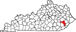 |
| Pike County | 195 | Pikeville | 1821 | Floyd County | Zebulon Pike (1779–1813), western explorer and discoverer of Pike's Peak | 57,391 | 788 sq mi (2,041 km2) | 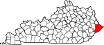 |
| Powell County | 197 | Stanton | 1852 | Clark County, Estill County, and Montgomery County | Lazarus Whitehead Powell, nineteenth Governor of Kentucky (1851–55) | 13,133 | 180 sq mi (466 km2) | 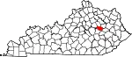 |
| Pulaski County | 199 | Somerset | 1798 | Green County and Lincoln County | Casimir Pulaski (1746–79), Polish-born Revolutionary War soldier killed at the Battle of Savannah | 65,423 | 662 sq mi (1,715 km2) | 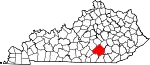 |
| Robertson County | 201 | Mount Olivet | 1867 | Bracken County, Harrison County, Mason County, and Nicholas County | George Robertson, chief justice of the Kentucky court of appeals (1828–43) | 2,257 | 100 sq mi (259 km2) | 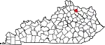 |
| Rockcastle County | 203 | Mount Vernon | 1810 | Lincoln County, Madison County, Knox County and Pulaski County | Rockcastle River, the boundary between Rockcastle and Laurel County | 16,115 | 318 sq mi (824 km2) | 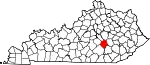 |
| Rowan County | 205 | Morehead | 1856 | Fleming County and Morgan County | John Rowan, Congressman from Kentucky (1809–11; 1825–31)) | 24,861 | 281 sq mi (728 km2) | 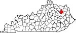 |
| Russell County | 207 | Jamestown | 1825 | Adair County, Wayne County and Cumberland County | William Russell (1758–1825), pioneer and state legislator | 18,156 | 254 sq mi (658 km2) | 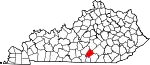 |
| Scott County | 209 | Georgetown | 1792 | Woodford County | Charles Scott (Governor of Kentucky), Revolutionary war general and later Governor of Kentucky (1808–12) | 58,252 | 285 sq mi (738 km2) | 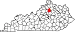 |
| Shelby County | 211 | Shelbyville | 1792 | Jefferson County | Isaac Shelby, first Governor of Kentucky (1792–96; 1812–16) | 48,461 | 384 sq mi (995 km2) | 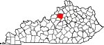 |
| Simpson County | 213 | Franklin | 1819 | Allen County, Logan County and Warren County | John Simpson, military captain killed at the Battle of Frenchtown | 19,718 | 236 sq mi (611 km2) | 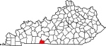 |
| Spencer County | 215 | Taylorsville | 1824 | Nelson County, Shelby County, and Bullitt County | Spier Spencer, military captain killed at the Battle of Tippecanoe | 19,916 | 186 sq mi (482 km2) | 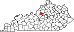 |
| Taylor County | 217 | Campbellsville | 1848 | Green County | Zachary Taylor, President of the United States (1849–50) | 26,235 | 270 sq mi (699 km2) | 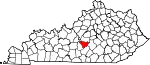 |
| Todd County | 219 | Elkton | 1819 | Logan County and Christian County | John Todd (1750–82), military colonel killed at the Battle of Blue Licks | 12,285 | 376 sq mi (974 km2) | 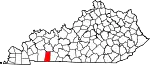 |
| Trigg County | 221 | Cadiz | 1820 | Christian County and Caldwell County | Stephen Trigg (1744–82), military colonel killed at the Battle of Blue Licks | 14,192 | 443 sq mi (1,147 km2) | 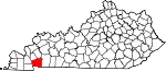 |
| Trimble County | 223 | Bedford | 1837 | Gallatin County, Henry County and Oldham County | Robert Trimble, Associate Supreme Court Justice (1826–28) | 8,530 | 149 sq mi (386 km2) | 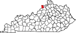 |
| Union County | 225 | Morganfield | 1811 | Henderson County | Unanimous decision of the residents to unite together and create a new county | 13,544 | 345 sq mi (894 km2) | 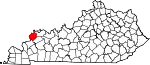 |
| Warren County | 227 | Bowling Green | 1796 | Logan County | Joseph Warren (1741–75), Revolutionary War general | 137,212 | 545 sq mi (1,412 km2) | 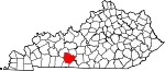 |
| Washington County | 229 | Springfield | 1792 | Jefferson County | George Washington, President of the United States (1789–97) | 12,072 | 301 sq mi (780 km2) | 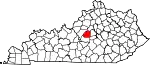 |
| Wayne County | 231 | Monticello | 1800 | Pulaski County and Cumberland County | Anthony Wayne (1745–96), Revolutionary War general | 19,540 | 459 sq mi (1,189 km2) | 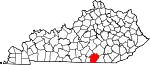 |
| Webster County | 233 | Dixon | 1860 | Henderson County, Hopkins County, and Union County | Daniel Webster, U.S. Senator from Massachusetts and United States Secretary of State (1841–43; 1850–52) | 12,813 | 335 sq mi (868 km2) | 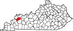 |
| Whitley County | 235 | Williamsburg | 1818 | Knox County | William Whitley (1749–1813), Kentucky pioneer | 36,939 | 440 sq mi (1,140 km2) | 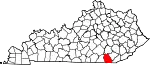 |
| Wolfe County | 237 | Campton | 1860 | Breathitt County, Owsley County, and Powell County | Nathaniel Wolfe (1808–65), member of the Kentucky General Assembly | 6,507 | 223 sq mi (578 km2) | 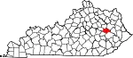 |
| Woodford County | 239 | Versailles | 1788 | Fayette County | William Woodford (1734–80), Revolutionary War general | 27,075 | 191 sq mi (495 km2) | 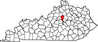 |
Clickable map
The map shown below is clickable; click on any county to be redirected to the page for that county, or use the text links shown above on this page.
See also
- List of United States counties and county equivalents
- Lists of U.S. county name etymologies
- List of cities in Kentucky
Notes
- "States, Counties, and Statistically Equivalent Entities" (PDF). Census Bureau.
{{cite web}}: CS1 maint: url-status (link) - Ireland, Robert M. (1992). "Counties". In Kleber, John E. (ed.). The Kentucky Encyclopedia. Lexington, Kentucky: The University Press of Kentucky. pp. 229–231. ISBN 0-8131-1772-0.
- "Fiscal Court". County Government in Kentucky: Informational Bulletin No. 115. Frankfort, Kentucky: Kentucky Legislative Research Commission. 1996.
- "Kentucky: Consolidated Chronology of State and County Boundaries". Atlas of Historical County Boundaries. Newberry Library. Retrieved May 22, 2021.
- Section 144, Kentucky Constitution of 1891
- "Boone County, Kentucky Fiscal Court". Archived from the original on July 25, 2007. Retrieved September 25, 2007.
- "County Government In Kentucky" (PDF). Legislative Research Commission. 2016.
{{cite web}}: CS1 maint: url-status (link) - "Candidate wants to abolish Fayette County's judge-executive office". Lexington Herald-Leader. November 2, 2010.
- National Association of Counties. "NACo – Find A County". Retrieved March 26, 2020.
- "Kentucky: Individual County Chronologies". Atlas of Historical County Boundaries. Newberry Library. Retrieved May 22, 2021.
- "U.S. Census Bureau QuickFacts: Kentucky". Retrieved March 31, 2022.
External links
- Kentucky Association of Counties
- County Profile Reports – Kentucky Center for Statistics
- Duties of Elected County Officials – Kentucky Legislative Research Commission
- National Association of Counties – Find A County
Commonwealth of Kentucky | |
|---|---|
Frankfort (capital) | |
| Topics | |
| Society | |
| Regions |
|
| 25 largest cities |
|
| Metropolitan areas |
|
| Counties |
|