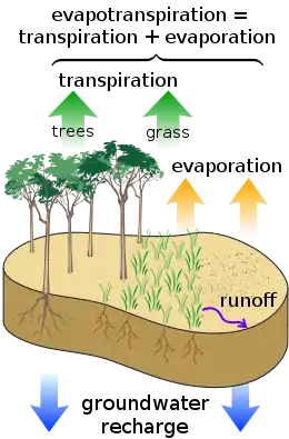
Evapotranspiration
Evapotranspiration (ET) is a term used to refer to the combined processes by which water moves from the earth’s surface into the atmosphere. It covers both water evaporation (movement of water to the air directly from soil, canopies, and water bodies) and transpiration (movement of water from the soil, through roots and bodies of vegetation, on leaves and then into the air). Evapotranspiration is an important part of the local water cycle and climate, as well as measurement of it plays a key role in agricultural irrigation and water resource management.[2]
Definition
Evapotranspiration is a combination of evaporation and transpiration, measured in order to better understand crop water requirements, irrigation scheduling,[3] and watershed management.[4] The two key components of evapotranspiration are:
- Evaporation: the movement of water directly to the air from sources such as the soil and water bodies. It can be affected by factors including heat, humidity, and wind speed.[5]: Ch. 1, “Evaporation”
- Transpiration: the movement of water from root systems, through a plant, and exit into the air as water vapor. This exit occurs through stomata in the plant. Rate of transpiration can be influenced by factors including plant type, soil type, weather conditions and water content, and also cultivation practices.[5]: Ch. 1, “Transpiration”
Evapotranspiration is typically measured in millimeters of water per a set unit of time.[5]: Ch. 1, “Units” Globally, it is estimated that on average between three-fifths and three-quarters of land precipitation is returned to the atmosphere via evapotranspiration.[6][7][8]: Ch. 1
Factors that impact evapotranspiration levels
Primary factors
Because evaporation and transpiration occur when water moves into the air, levels of evapotranspiration in a given area are primarily controlled by:[9]
- the amount of water present;
- the amount of energy present in the air and soil (e.g. heat); and
- the ability of the atmosphere to take up water (humidity).
Vegetation type
Vegetation type can impact levels of evapotranspiration by impacting the factors listed above. For example:
- Herbaceous plants generally transpire less than woody plants, because they usually have less extensive foliage.
- Plants with deep reaching roots can transpire water more constantly, because water transpired through leaves comes from the roots.
- Conifer forests tend to have higher rates of evapotranspiration than deciduous broadleaf forests, particularly in the dormant winter and early spring seasons, because they are evergreen.[10]
Factors that affect evapotranspiration include the plant's growth stage or level of maturity, it's species, percentage of soil cover, soil type, solar radiation, humidity, temperature, and wind.
Vegetation coverage
Transpiration is a larger component of evapotranspiration (relative to evaporation) in vegetation-abundant areas.[11] As a result, denser vegetation like forests may reduce water yield.
Two exception to this are cloud forests and rainforests. In cloud forests, trees collect the liquid water in fog or low clouds onto their surface, which eventually drips down to the ground. These trees still contribute to evapotranspiration, but often collect more water than they evaporate or transpire.[12][13] In rainforests, water yield is increased (compared to cleared, unforested land in the same climatic zone) as evapotranspiration increases humidity within the forest (a portion of which condenses and returns quickly as precipitation experienced at ground level as rain). The density of the vegetation blocks sunlight and reduces temperatures at ground level (thereby reducing losses due to surface evaporation), and reduces wind speeds (thereby reducing the loss of airborne moisture). The combined effect results in increased surface stream flows and a higher ground water table whilst the rainforest is preserved. Clearing of rainforests frequently leads to desertification as ground level temperatures and wind speeds increase, vegetation cover is lost or intentionally destroyed by clearing and burning, soil moisture is reduced by wind, and soils are easily eroded by high wind and rainfall events.[14][15]
Soil and irrigation
In areas that are not irrigated, actual evapotranspiration is usually no greater than precipitation, with some buffer and variations in time depending on the soil's ability to hold water. It will usually be less because some water will be lost due to percolation or surface runoff. An exception is areas with high water tables, where capillary action can cause water from the groundwater to rise through the soil matrix back to the surface. If potential evapotranspiration is greater than the actual precipitation, then soil will dry out until conditions stabilize, unless irrigation is used.
Measurement
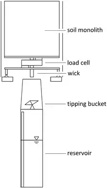
Evapotranspiration can be measured directly with a weighing or pan lysimeter. A lysimeter continuously measures the weight of a plant and associated soil, and any water added by precipitation or irrigation. The change in storage of water in the soil is then modeled by measuring the change in weight. When used properly, this allows for precise measurement of evapotranspiration on small areas.
Indirect estimation
Because atmospheric vapor flux is difficult or time consuming to measure directly,[8]: Ch. 1 evapotranspiration is typically estimated by one of several different methods that do not rely on direct measurement.
Catchment water balance
Evapotranspiration may be estimated by evaluating the water balance of a drainage basin. The water balance equation relates the change in water stored within the basin (S) to its input and outputs:

The input is precipitation (P) and the outputs are evapotranspiration (which is to be estimated), streamflow (Q), and groundwater recharge (D). If the change in storage, precipitation, streamflow, and groundwater recharge are all estimated, the missing flux, ET, can be estimated by rearranging the above equation as follows:

Energy balance
A second methodology to estimate the actual evapotranspiration is the use of the energy balance.

where λE is the energy needed to change the phase of water from liquid to gas, Rn is the net radiation, G is the soil heat flux and H is the sensible heat flux. Using instruments like a scintillometer, soil heat flux plates or radiation meters, the components of the energy balance can be calculated and the energy available for actual evapotranspiration can be solved.
The SEBAL and METRIC algorithms solve the energy balance at the earth's surface using satellite imagery. This allows for both actual and potential evapotranspiration to be calculated on a pixel-by-pixel basis. Evapotranspiration is a key indicator for water management and irrigation performance. SEBAL and METRIC can map these key indicators in time and space, for days, weeks or years.[16]
Estimation from meteorological data
Given meteorological data like wind, temperature, and humidity, reference ET can be calculated. The most general and widely used equation for calculating reference ET is the Penman equation. The Penman–Monteith variation is recommended by the Food and Agriculture Organization[17] and the American Society of Civil Engineers.[18] The simpler Blaney–Criddle equation was popular in the Western United States for many years but it is not as accurate in wet regions with higher humidity. Other equations for estimating evapotranspiration from meteorological data includes the Makkink, which is simple but must be calibrated to a specific location, and lastly the Hargreaves equations.
To convert the reference evapotranspiration to the actual crop evapotranspiration, a crop coefficient and a stress coefficient must be used. Crop coefficients as used in many hydrological models usually change along the year to accommodate to the fact that crops are seasonal and, in general, plants behave differently along the seasons: perennial plants mature over multiple seasons, while annuals do not survive more than a few, so stress responses can significantly depend upon many aspects of plant type and condition.
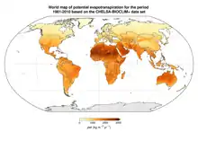
Potential evapotranspiration
Potential evapotranspiration (PET) is the amount of water that would be evaporated and transpired by a specific crop, soil or ecosystem if there were sufficient water available. It is a reflection of the energy available to evaporate or transpire water, and of the wind available to transport the water vapor from the ground up into the lower atmosphere and away from the initial location. Often a value for the potential evapotranspiration is calculated at a nearby climatic station on a reference surface, conventionally on land dominated by short grass (though may differ from station to station). This value is called the reference evapotranspiration (ET0). Actual evapotranspiration is said to equal potential evapotranspiration when there is ample water existent. Evapotranspiration can never be greater than potential evapotranspiration, but can be lower if there is not enough water to be evaporated or plants are unable to transpire maturely and readily.
Some US states utilize a full cover alfalfa reference crop that is 0.5 m (1.6 ft) in height, rather than the general short green grass reference, due to the higher value of ET from the alfalfa reference.[19] Potential evapotranspiration is higher in the summer, on clearer and less cloudy days, and closer to the equator, because of the higher levels of solar radiation that provides the energy (heat) for evaporation. Potential evapotranspiration is also higher on windy days because the evaporated moisture can be quickly moved from the ground or plant surface before it precipitates, allowing more evaporation to fill its place.
Potential evapotranspiration is expressed in terms of a depth of water or soil moisture percentage, and can be graphed during the year (see figure).
Potential evapotranspiration is usually measured indirectly, from other climatic factors, but also depends on the surface type, such as free water (for lakes and oceans), the soil type for bare soil, and also the density and diversity of vegetation. Often a value for the potential evapotranspiration is calculated at a nearby climate station on a reference surface, conventionally on short grass (see above). This value is called the reference evapotranspiration, and can be converted to a potential evapotranspiration by multiplying with a surface coefficient. In agriculture, this is called a crop coefficient. The difference between potential evapotranspiration and the actual precipitation is used in irrigation scheduling.
Average annual potential evapotranspiration is often compared to average annual precipitation, the symbol of which is P. The ratio of the two, P/PET, is the aridity index. A humid subtropical climate is a zone of climate characterized by hot and humid summers, and cold to mild winters. Subarctic regions have short, mild summers and freezing winters, falling between 50°N and 70°N latitude, depending on local climates. Precipitation and evapotranspiration is low (compared to warmer variants), and vegetation is characteristic of the coniferous/taiga forest.
List of remote sensing based evapotranspiration models

See also
- Eddy covariance flux (aka eddy correlation, eddy flux)
- Hydrology (agriculture)
- Hydrologic Evaluation of Landfill Performance (HELP)
- Latent heat flux
- Water Evaluation And Planning system (WEAP)
- Soil plant atmosphere continuum
- Deficit irrigation
- Evaporation
- Transpiration
- Precipitation
References
- Brun, P., Zimmermann, N.E., Hari, C., Pellissier, L., Karger, D.N. (preprint): Global climate-related predictors at kilometre resolution for the past and future. Earth Syst. Sci. Data Discuss. https://doi.org/10.5194/essd-2022-212
- "Evapotranspiration - an overview | ScienceDirect Topics". www.sciencedirect.com. Retrieved 2022-05-02.
- Goyal, Megh R.; Harmsen, Eric W. (2013-09-26). Evapotranspiration: Principles and Applications for Water Management. CRC Press. pp. xxi. ISBN 978-1-926895-58-1.
- Vörösmarty, C. J.; Federer, C. A.; Schloss, A. L. (1998-06-25). "Potential evaporation functions compared on US watersheds: Possible implications for global-scale water balance and terrestrial ecosystem modeling". Journal of Hydrology. 207 (3): 147–169. Bibcode:1998JHyd..207..147V. doi:10.1016/S0022-1694(98)00109-7. ISSN 0022-1694.
- Allen, Rick G. (1998). Crop Evapotranspiration: Guidelines for Computing Crop Water Requirements. Food and Agriculture Organization of the United Nations. ISBN 978-92-5-104219-9.
{{cite book}}: CS1 maint: date and year (link) - Jung, Martin; Reichstein, Markus; Ciais, Philippe; Seneviratne, Sonia I.; Sheffield, Justin; Goulden, Michael L.; Bonan, Gordon; Cescatti, Alessandro; Chen, Jiquan; de Jeu, Richard; Dolman, A. Johannes (2010-10-21). "Recent decline in the global land evapotranspiration trend due to limited moisture supply". Nature. 467 (7318): 951–954. Bibcode:2010Natur.467..951J. doi:10.1038/nature09396. ISSN 1476-4687. PMID 20935626. S2CID 4334266.
- Oki, Taikan; Kanae, Shinjiro (2006-08-25). "Global Hydrological Cycles and World Water Resources". Science. 313 (5790): 1068–1072. Bibcode:2006Sci...313.1068O. doi:10.1126/science.1128845. PMID 16931749. S2CID 39993634.
- Alexandris, Stavros (2013-04-30). Evapotranspiration: An Overview. BoD – Books on Demand. ISBN 978-953-51-1115-3.
- Alfieri, J.G.; Kustas, W.P.; Anderson, M.C. (2018-06-05), A Brief Overview of Approaches for Measuring Evapotranspiration, Agronomy Monographs, Madison, WI, USA: American Society of Agronomy, Crop Science Society of America, and Soil Science Society of America, Inc., pp. 109–127, doi:10.2134/agronmonogr60.2016.0034, ISBN 9780891183587, S2CID 133852825, retrieved 2022-03-10
- Swank, Wayne T.; Douglass, James E. (1974-09-06). "Streamflow Greatly Reduced by Converting Deciduous Hardwood Stands to Pine" (PDF). Science. 185 (4154): 857–859. Bibcode:1974Sci...185..857S. doi:10.1126/science.185.4154.857. ISSN 0036-8075. PMID 17833698. S2CID 42654218.
- Jasechko, Scott; Sharp, Zachary D.; Gibson, John J.; Birks, S. Jean; Yi, Yi; Fawcett, Peter J. (3 April 2013). "Terrestrial water fluxes dominated by transpiration". Nature. 496 (7445): 347–50. Bibcode:2013Natur.496..347J. doi:10.1038/nature11983. PMID 23552893. S2CID 4371468.
- Holder, Curtis D (2004-03-22). "Rainfall interception and fog precipitation in a tropical montane cloud forest of Guatemala". Forest Ecology and Management. 190 (2): 373–384. doi:10.1016/j.foreco.2003.11.004. ISSN 0378-1127.
- "Cloud Forest". Community Cloud Forest Conservation. Retrieved 2022-05-02.
- "How plants play a vital role for rainfall within the tropical rainforest | Britannica". www.britannica.com. Retrieved 2022-05-02.
- "Validate User". academic.oup.com. Retrieved 2022-05-02.
- "SEBAL_ WaterWatch". Archived from the original on 2011-07-13.
- Allen, R.G.; Pereira, L.S.; Raes, D.; Smith, M. (1998). Crop Evapotranspiration: Guidelines for Computing Crop Water Requirements. FAO Irrigation and drainage paper 56. Rome, Italy: Food and Agriculture Organization of the United Nations. ISBN 978-92-5-104219-9. Archived from the original on 2011-05-15. Retrieved 2011-06-08.
- Rojas, Jose P.; Sheffield, Ronald E. (2013). "Evaluation of Daily Reference Evapotranspiration Methods as Compared with the ASCE-EWRI Penman-Monteith Equation Using Limited Weather Data in Northeast Louisiana". Journal of Irrigation and Drainage Engineering. 139 (4): 285–292. doi:10.1061/(ASCE)IR.1943-4774.0000523. ISSN 0733-9437.
- "Kimberly Research and Extension Center" (PDF). extension.uidaho.edu. Archived from the original (PDF) on 4 March 2016. Retrieved 4 May 2018.
- Anderson, M. C.; Kustas, W. P.; Norman, J. M.; Hain, C. R.; Mecikalski, J. R.; Schultz, L.; González-Dugo, M. P.; Cammalleri, C.; d'Urso, G.; Pimstein, A.; Gao, F. (2011-01-21). "Mapping daily evapotranspiration at field to continental scales using geostationary and polar orbiting satellite imagery". Hydrology and Earth System Sciences. 15 (1): 223–239. Bibcode:2011HESS...15..223A. doi:10.5194/hess-15-223-2011. ISSN 1607-7938.
{{cite journal}}: CS1 maint: multiple names: authors list (link) - Dhungel, Ramesh; Aiken, Robert; Colaizzi, Paul D.; Lin, Xiaomao; O'Brien, Dan; Baumhardt, R. Louis; Brauer, David K.; Marek, Gary W. (2019-07-15). "Evaluation of uncalibrated energy balance model (BAITSSS) for estimating evapotranspiration in a semiarid, advective climate". Hydrological Processes. 33 (15): 2110–2130. Bibcode:2019HyPr...33.2110D. doi:10.1002/hyp.13458. ISSN 0885-6087. S2CID 146551438.
- Dhungel, Ramesh; Allen, Richard G.; Trezza, Ricardo; Robison, Clarence W. (2016). "Evapotranspiration between satellite overpasses: methodology and case study in agricultural dominant semi-arid areas". Meteorological Applications. 23 (4): 714–730. Bibcode:2016MeApp..23..714D. doi:10.1002/met.1596. ISSN 1469-8080.
- Allen Richard G.; Tasumi Masahiro; Trezza Ricardo (2007-08-01). "Satellite-Based Energy Balance for Mapping Evapotranspiration with Internalized Calibration (METRIC)—Model". Journal of Irrigation and Drainage Engineering. 133 (4): 380–394. doi:10.1061/(ASCE)0733-9437(2007)133:4(380).
- Abtew W. Evapotranspiration Measurements and Modeling for Three Wetland Systems in South Florida. J. Am. Water Resour. Assn. 1996;32:465–473.
- Bastiaanssen, W. G. M.; Menenti, M.; Feddes, R. A.; Holtslag, A. A. M. (1998-12-01). "A remote sensing surface energy balance algorithm for land (SEBAL). 1. Formulation". Journal of Hydrology. 212–213: 198–212. Bibcode:1998JHyd..212..198B. doi:10.1016/S0022-1694(98)00253-4. ISSN 0022-1694.
- Su, Z. (2002). "The Surface Energy Balance System (SEBS) for estimation of turbulent heat fluxes". Hydrology and Earth System Sciences. 6 (1): 85–100. Bibcode:2002HESS....6...85S. doi:10.5194/hess-6-85-2002. ISSN 1607-7938.
- Senay, Gabriel B.; Bohms, Stefanie; Singh, Ramesh K.; Gowda, Prasanna H.; Velpuri, Naga M.; Alemu, Henok; Verdin, James P. (2013-05-13). "Operational Evapotranspiration Mapping Using Remote Sensing and Weather Datasets: A New Parameterization for the SSEB Approach". JAWRA Journal of the American Water Resources Association. 49 (3): 577–591. Bibcode:2013JAWRA..49..577S. doi:10.1111/jawr.12057. ISSN 1093-474X.