Cyclone
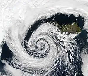
In meteorology, a cyclone (/ˈsaɪ.kloʊn/) is a large air mass that rotates around a strong center of low atmospheric pressure, counterclockwise in the Northern Hemisphere and clockwise in the Southern Hemisphere as viewed from above (opposite to an anticyclone).[1][2] Cyclones are characterized by inward-spiraling winds that rotate about a zone of low pressure.[3][4] The largest low-pressure systems are polar vortices and extratropical cyclones of the largest scale (the synoptic scale). Warm-core cyclones such as tropical cyclones and subtropical cyclones also lie within the synoptic scale.[5] Mesocyclones, tornadoes, and dust devils lie within smaller mesoscale.[6] Upper level cyclones can exist without the presence of a surface low, and can pinch off from the base of the tropical upper tropospheric trough during the summer months in the Northern Hemisphere. Cyclones have also been seen on extraterrestrial planets, such as Mars, Jupiter, and Neptune.[7][8] Cyclogenesis is the process of cyclone formation and intensification.[9] Extratropical cyclones begin as waves in large regions of enhanced mid-latitude temperature contrasts called baroclinic zones. These zones contract and form weather fronts as the cyclonic circulation closes and intensifies. Later in their life cycle, extratropical cyclones occlude as cold air masses undercut the warmer air and become cold core systems. A cyclone's track is guided over the course of its 2 to 6 day life cycle by the steering flow of the subtropical jet stream.
| Part of a series on |
| Weather |
|---|
 |
|
|
Weather fronts mark the boundary between two masses of air of different temperature, humidity, and densities, and are associated with the most prominent meteorological phenomena. Strong cold fronts typically feature narrow bands of thunderstorms and severe weather, and may on occasion be preceded by squall lines or dry lines. Such fronts form west of the circulation center and generally move from west to east; warm fronts form east of the cyclone center and are usually preceded by stratiform precipitation and fog. Warm fronts move poleward ahead of the cyclone path. Occluded fronts form late in the cyclone life cycle near the center of the cyclone and often wrap around the storm center.
Tropical cyclogenesis describes the process of development of tropical cyclones. Tropical cyclones form due to latent heat driven by significant thunderstorm activity, and are warm core.[10][11] Cyclones can transition between extratropical, subtropical, and tropical phases.[12] Mesocyclones form as warm core cyclones over land, and can lead to tornado formation.[13] Waterspouts can also form from mesocyclones, but more often develop from environments of high instability and low vertical wind shear.[14] In the Atlantic and the northeastern Pacific oceans, a tropical cyclone is generally referred to as a hurricane (from the name of the ancient Central American deity of wind, Huracan), in the Indian and south Pacific oceans it is called a cyclone, and in the northwestern Pacific it is called a typhoon.[15] The growth of instability in the vortices is not universal. For example, the size, intensity, moist-convection, surface evaporation, the value of potential temperature at each potential height can affect the nonlinear evolution of a vortex.[16][17]
Nomenclature
Henry Piddington published 40 papers dealing with tropical storms from Calcutta between 1836 and 1855 in The Journal of the Asiatic Society. He also coined the term cyclone, meaning the coil of a snake. In 1842, he published his landmark thesis, Laws of the Storms.[18]
Structure
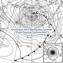
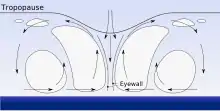
There are a number of structural characteristics common to all cyclones. A cyclone is a low-pressure area.[19] A cyclone's center (often known in a mature tropical cyclone as the eye), is the area of lowest atmospheric pressure in the region.[19] Near the center, the pressure gradient force (from the pressure in the center of the cyclone compared to the pressure outside the cyclone) and the force from the Coriolis effect must be in an approximate balance, or the cyclone would collapse on itself as a result of the difference in pressure.[20]
Because of the Coriolis effect, the wind flow around a large cyclone is counterclockwise in the Northern Hemisphere and clockwise in the Southern Hemisphere.[21] In the Northern Hemisphere, the fastest winds relative to the surface of the Earth therefore occur on the eastern side of a northward-moving cyclone and on the northern side of a westward-moving one; the opposite occurs in the Southern Hemisphere.[22] In contrast to low-pressure systems, the wind flow around high-pressure systems are clockwise (anticyclonic) in the northern hemisphere, and counterclockwise in the southern hemisphere.
Formation
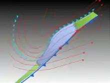
Cyclogenesis is the development or strengthening of cyclonic circulation in the atmosphere.[9] Cyclogenesis is an umbrella term for several different processes that all result in the development of some sort of cyclone.[24] It can occur at various scales, from the microscale to the synoptic scale.
Extratropical cyclones begin as waves along weather fronts before occluding later in their life cycle as cold-core systems. However, some intense extratropical cyclones can become warm-core systems when a warm seclusion occurs.
Tropical cyclones form as a result of significant convective activity, and are warm core.[11] Mesocyclones form as warm core cyclones over land, and can lead to tornado formation.[13] Waterspouts can also form from mesocyclones, but more often develop from environments of high instability and low vertical wind shear.[14] Cyclolysis is the opposite of cyclogenesis, and is the high-pressure system equivalent, which deals with the formation of high-pressure areas—Anticyclogenesis.[25]
A surface low can form in a variety of ways. Topography can create a surface low. Mesoscale convective systems can spawn surface lows that are initially warm-core.[26] The disturbance can grow into a wave-like formation along the front and the low is positioned at the crest. Around the low, the flow becomes cyclonic. This rotational flow moves polar air towards the equator on the west side of the low, while warm air move towards the pole on the east side. A cold front appears on the west side, while a warm front forms on the east side. Usually, the cold front moves at a quicker pace than the warm front and "catches up" with it due to the slow erosion of higher density air mass out ahead of the cyclone. In addition, the higher density air mass sweeping in behind the cyclone strengthens the higher pressure, denser cold air mass. The cold front over takes the warm front, and reduces the length of the warm front.[27] At this point an occluded front forms where the warm air mass is pushed upwards into a trough of warm air aloft, which is also known as a trowal.[28]
Tropical cyclogenesis is the development and strengthening of a tropical cyclone.[29] The mechanisms by which tropical cyclogenesis occurs are distinctly different from those that produce mid-latitude cyclones. Tropical cyclogenesis, the development of a warm-core cyclone, begins with significant convection in a favorable atmospheric environment. There are six main requirements for tropical cyclogenesis:
- sufficiently warm sea surface temperatures,[30]
- atmospheric instability,
- high humidity in the lower to middle levels of the troposphere
- enough Coriolis force to develop a low-pressure center
- a preexisting low-level focus or disturbance
- low vertical wind shear.[31]
An average of 86 tropical cyclones of tropical storm intensity form annually worldwide,[32] with 47 reaching hurricane/typhoon strength, and 20 becoming intense tropical cyclones (at least Category 3 intensity on the Saffir–Simpson hurricane scale).[33]
Synoptic scale

The following types of cyclones are identifiable in synoptic charts.
Surface-based types
There are three main types of surface-based cyclones: Extratropical cyclones, Subtropical cyclones and Tropical cyclones
Extratropical cyclone
An extratropical cyclone is a synoptic scale low-pressure weather system that does not have tropical characteristics,[34] as it is connected with fronts and horizontal gradients (rather than vertical) in temperature and dew point otherwise known as "baroclinic zones".[35]
"Extratropical" is applied to cyclones outside the tropics, in the middle latitudes. These systems may also be described as "mid-latitude cyclones" due to their area of formation, or "post-tropical cyclones" when a tropical cyclone has moved (extratropical transition) beyond the tropics.[35][36] They are often described as "depressions" or "lows" by weather forecasters and the general public. These are the everyday phenomena that, along with anticyclones, drive weather over much of the Earth.
Although extratropical cyclones are almost always classified as baroclinic since they form along zones of temperature and dewpoint gradient within the westerlies, they can sometimes become barotropic late in their life cycle when the temperature distribution around the cyclone becomes fairly uniform with radius.[37] An extratropical cyclone can transform into a subtropical storm, and from there into a tropical cyclone, if it dwells over warm waters sufficient to warm its core, and as a result develops central convection.[38] A particularly intense type of extratropical cyclone that strikes during winter is known colloquially as a nor'easter.
Polar low
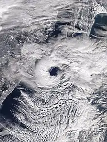
A polar low is a small-scale, short-lived atmospheric low-pressure system (depression) that is found over the ocean areas poleward of the main polar front in both the Northern and Southern Hemispheres. Polar lows were first identified on the meteorological satellite imagery that became available in the 1960s, which revealed many small-scale cloud vortices at high latitudes. The most active polar lows are found over certain ice-free maritime areas in or near the Arctic during the winter, such as the Norwegian Sea, Barents Sea, Labrador Sea and Gulf of Alaska. Polar lows dissipate rapidly when they make landfall. Antarctic systems tend to be weaker than their northern counterparts since the air-sea temperature differences around the continent are generally smaller . However, vigorous polar lows can be found over the Southern Ocean. During winter, when cold-core lows with temperatures in the mid-levels of the troposphere reach −45 °C (−49 °F) move over open waters, deep convection forms, which allows polar low development to become possible.[39] The systems usually have a horizontal length scale of less than 1,000 kilometres (620 mi) and exist for no more than a couple of days. They are part of the larger class of mesoscale weather systems. Polar lows can be difficult to detect using conventional weather reports and are a hazard to high-latitude operations, such as shipping and gas and oil platforms. Polar lows have been referred to by many other terms, such as polar mesoscale vortex, Arctic hurricane, Arctic low, and cold air depression. Today the term is usually reserved for the more vigorous systems that have near-surface winds of at least 17 m/s.[40]
Subtropical
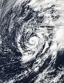
A subtropical cyclone is a weather system that has some characteristics of a tropical cyclone and some characteristics of an extratropical cyclone. They can form between the equator and the 50th parallel.[41] As early as the 1950s, meteorologists were unclear whether they should be characterized as tropical cyclones or extratropical cyclones, and used terms such as quasi-tropical and semi-tropical to describe the cyclone hybrids.[42] By 1972, the National Hurricane Center officially recognized this cyclone category.[43] Subtropical cyclones began to receive names off the official tropical cyclone list in the Atlantic Basin in 2002.[41] They have broad wind patterns with maximum sustained winds located farther from the center than typical tropical cyclones, and exist in areas of weak to moderate temperature gradient.[41]
Since they form from extratropical cyclones, which have colder temperatures aloft than normally found in the tropics, the sea surface temperatures required is around 23 degrees Celsius (73 °F) for their formation, which is three degrees Celsius (5 °F) lower than for tropical cyclones.[44] This means that subtropical cyclones are more likely to form outside the traditional bounds of the hurricane season. Although subtropical storms rarely have hurricane-force winds, they may become tropical in nature as their cores warm.[45]
Tropical
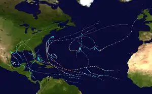
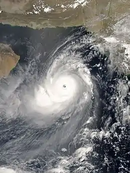
A tropical cyclone is a storm system characterized by a low-pressure center and numerous thunderstorms that produce strong winds and flooding rain.[46] A tropical cyclone feeds on heat released when moist air rises, resulting in condensation of water vapour contained in the moist air.[46] They are fueled by a different heat mechanism than other cyclonic windstorms such as nor'easters, European windstorms, and polar lows, leading to their classification as "warm core" storm systems.[46][11]

The term "tropical" refers to both the geographic origin of these systems, which form almost exclusively in tropical regions of the globe,[47] and their dependence on Maritime Tropical air masses for their formation. The term "cyclone" refers to the storms' cyclonic nature, with counterclockwise rotation in the Northern Hemisphere and clockwise rotation in the Southern Hemisphere.[47] Depending on their location and strength, tropical cyclones are referred to by other names, such as hurricane, typhoon, tropical storm, cyclonic storm, tropical depression, or simply as a cyclone.[47]
While tropical cyclones can produce extremely powerful winds and torrential rain, they are also able to produce high waves and a damaging storm surge.[48] Their winds increase the wave size, and in so doing they draw more heat and moisture into their system, thereby increasing their strength. They develop over large bodies of warm water,[49] and hence lose their strength if they move over land.[50] This is the reason coastal regions can receive significant damage from a tropical cyclone, while inland regions are relatively safe from strong winds.[47] Heavy rains, however, can produce significant flooding inland.[47] Storm surges are rises in sea level caused by the reduced pressure of the core that in effect "sucks" the water upward and from winds that in effect "pile" the water up. Storm surges can produce extensive coastal flooding up to 40 kilometres (25 mi) from the coastline.[47] Although their effects on human populations can be devastating, tropical cyclones can also relieve drought conditions.[51] They also carry heat and energy away from the tropics and transport it toward temperate latitudes,[47] which makes them an important part of the global atmospheric circulation mechanism. As a result, tropical cyclones help to maintain equilibrium in the Earth's troposphere.[47]
Many tropical cyclones develop when the atmospheric conditions around a weak disturbance in the atmosphere are favorable.[47] Others form when other types of cyclones acquire tropical characteristics. Tropical systems are then moved by steering winds in the troposphere; if the conditions remain favorable, the tropical disturbance intensifies, and can even develop an eye. On the other end of the spectrum, if the conditions around the system deteriorate or the tropical cyclone makes landfall, the system weakens and eventually dissipates. A tropical cyclone can become extratropical as it moves toward higher latitudes if its energy source changes from heat released by condensation to differences in temperature between air masses.[11] A tropical cyclone is usually not considered to become subtropical during its extratropical transition.[52]
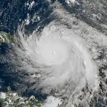 Atlantic hurricane

.jpg.webp)
 Australian region cyclone
 South-West Indian Ocean cyclone
Polar cyclone
A polar, sub-polar, or Arctic cyclone (also known as a polar vortex)[53] is a vast area of low pressure that strengthens in the winter and weakens in the summer.[54] A polar cyclone is a low-pressure weather system, usually spanning 1,000 kilometres (620 mi) to 2,000 kilometres (1,200 mi),[55] in which the air circulates in a counterclockwise direction in the northern hemisphere, and a clockwise direction in the southern hemisphere. The Coriolis acceleration acting on the air masses moving poleward at high altitude, causes a counterclockwise circulation at high altitude. The poleward movement of air originates from the air circulation of the Polar cell. The polar low is not driven by convection as are tropical cyclones, nor the cold and warm air mass interactions as are extratropical cyclones, but is an artifact of the global air movement of the Polar cell. The base of the polar low is in the mid to upper troposphere. In the Northern Hemisphere, the polar cyclone has two centers on average. One center lies near Baffin Island and the other over northeast Siberia.[53] In the southern hemisphere, it tends to be located near the edge of the Ross ice shelf near 160 west longitude.[56] When the polar vortex is strong, its effect can be felt at the surface as a westerly wind (toward the east). When the polar cyclone is weak, significant cold outbreaks occur.[57]
TUTT cell
Under specific circumstances, upper level cold lows can break off from the base of the tropical upper tropospheric trough (TUTT), which is located mid-ocean in the Northern Hemisphere during the summer months. These upper tropospheric cyclonic vortices, also known as TUTT cells or TUTT lows, usually move slowly from east-northeast to west-southwest, and their bases generally do not extend below 20,000 feet (6,100 m) in altitude. A weak inverted surface trough within the trade wind is generally found underneath them, and they may also be associated with broad areas of high-level clouds. Downward development results in an increase of cumulus clouds and the appearance of a surface vortex. In rare cases, they become warm-core tropical cyclones. Upper cyclones and the upper troughs that trail tropical cyclones can cause additional outflow channels and aid in their intensification. Developing tropical disturbances can help create or deepen upper troughs or upper lows in their wake due to the outflow jet emanating from the developing tropical disturbance/cyclone.[58][59]
Mesoscale
The following types of cyclones are not identifiable in synoptic charts.
Mesocyclone
A mesocyclone is a vortex of air, 2.0 kilometres (1.2 mi) to 10 kilometres (6.2 mi) in diameter (the mesoscale of meteorology), within a convective storm.[60] Air rises and rotates around a vertical axis, usually in the same direction as low-pressure systems[61] in both northern and southern hemisphere. They are most often cyclonic, that is, associated with a localized low-pressure region within a supercell.[61][62] Such storms can feature strong surface winds and severe hail.[61] Mesocyclones often occur together with updrafts in supercells, where tornadoes may form.[61] About 1,700 mesocyclones form annually across the United States, but only half produce tornadoes.[13]
Tornado
A tornado is a violently rotating column of air that is in contact with both the surface of the earth and a cumulonimbus cloud or,[63] in rare cases, the base of a cumulus cloud. Also referred to as twisters, a colloquial term in America, or cyclones, although the word cyclone is used in meteorology, in a wider sense, to name any closed low-pressure circulation.
Dust devil
A dust devil is a strong, well-formed, and relatively long-lived whirlwind,[64] ranging from small (half a metre wide and a few metres tall) to large (more than 10 metres wide and more than 1000 metres tall).[64] The primary vertical motion is upward.[64] Dust devils are usually harmless, but can on rare occasions grow large enough to pose a threat to both people and property.[64]
Waterspout
A waterspout is a columnar vortex forming over water that is, in its most common form, a non-supercell tornado over water that is connected to a cumuliform cloud. While it is often weaker than most of its land counterparts, stronger versions spawned by mesocyclones do occur.
Steam devil
A gentle vortex over calm water or wet land made visible by rising water vapour.
Fire whirl
A fire whirl – also colloquially known as a fire devil, fire tornado, firenado, or fire twister – is a whirlwind induced by a fire and often made up of flame or ash.
Other planets
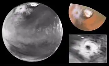
Cyclones are not unique to Earth. Cyclonic storms are common on Jovian planets, such as the Small Dark Spot on Neptune.[65] It is about one third the diameter of the Great Dark Spot and received the nickname "Wizard's Eye" because it looks like an eye. This appearance is caused by a white cloud in the middle of the Wizard's Eye.[8] Mars has also exhibited cyclonic storms.[7] Jovian storms like the Great Red Spot are usually mistakenly named as giant hurricanes or cyclonic storms. However, this is inaccurate, as the Great Red Spot is, in fact, the inverse phenomenon, an anticyclone.[66]
See also
- Tropical cyclone
- Subtropical cyclone
- Extratropical cyclone
- Tornado
- Storm
- Atlantic hurricane
- Australian region tropical cyclone
- Space hurricane
- Space tornado
References
- Glossary of Meteorology (June 2000). "Cyclonic circulation". American Meteorological Society. Retrieved 2008-09-17.
- Glossary of Meteorology (June 2000). "Cyclone". American Meteorological Society. Retrieved 2008-09-17.
- BBC Weather Glossary (July 2006). "Cyclone". BBC. Archived from the original on 2006-08-29. Retrieved 2006-10-24.
- "UCAR Glossary — Cyclone". University Corporation for Atmospheric Research. Retrieved 2006-10-24.
- National Hurricane Center (2012). Glossary of NHC terms. Retrieved on 2012-08-13.
- I. Orlanski (1975). "A rational subdivision of scales for atmospheric processes". Bulletin of the American Meteorological Society. 56 (5): 527–530. Bibcode:1975BAMS...56..527.. doi:10.1175/1520-0477-56.5.527.
- David Brand (1999-05-19). "Colossal cyclone swirling near Martian north pole is observed by Cornell-led team on Hubble telescope". Cornell University. Archived from the original on June 13, 2007. Retrieved 2008-06-15.
- Samantha Harvey (2006-10-02). "Historic Hurricanes". NASA. Archived from the original on 2008-04-15. Retrieved 2008-06-14.
- Nina A. Zaitseva (2006). "Cyclogenesis". National Snow and Ice Data Center. Archived from the original on 2006-08-30. Retrieved 2006-12-04.
- "Tropical cyclogenesis". www-das.uwyo.edu. Retrieved 12 January 2021.
- Stan Goldenberg (2004-08-13). "Frequently Asked Questions: What is an extra-tropical cyclone?". Atlantic Oceanographic and Meteorological Laboratory, Hurricane Research Division. Retrieved 2007-03-23.
- Evans, Clark; Wood, Kimberly M.; Aberson, Sim D.; Archambault, Heather M.; Milrad, Shawn M.; Bosart, Lance F.; Corbosiero, Kristen L.; Davis, Christopher A.; Pinto, João R. Dias; Doyle, James; Fogarty, Chris; Galarneau, Thomas J.; Grams, Christian M.; Griffin, Kyle S.; Gyakum, John; Hart, Robert E.; Kitabatake, Naoko; Lentink, Hilke S.; McTaggart-Cowan, Ron; Perrie, William; Quinting, Julian F. D.; Reynolds, Carolyn A.; Riemer, Michael; Ritchie, Elizabeth A.; Sun, Yujuan; Zhang, Fuqing (1 November 2017). "The Extratropical Transition of Tropical Cyclones. Part I: Cyclone Evolution and Direct Impacts". Monthly Weather Review. 145 (11): 4317–4344. Bibcode:2017MWRv..145.4317E. doi:10.1175/MWR-D-17-0027.1. ISSN 1520-0493. S2CID 38114516. Retrieved 12 January 2021.
- Forces of Nature. Tornadoes : the mesocyclone. Archived 2008-06-16 at the Wayback Machine Retrieved on 2008-06-15.
- National Weather Service Key West summary of waterspout types
- "Frequently asked questions". Hurricane Research Division.
- Rostami, Masoud; Zeitlin, Vladimir (2017). "Influence of condensation and latent heat release upon barotropic and baroclinic instabilities of vortices in a rotating shallow water f-plane model" (PDF). Geophysical & Astrophysical Fluid Dynamics. 111 (1): 1–31. Bibcode:2017GApFD.111....1R. doi:10.1080/03091929.2016.1269897. S2CID 55112620.
- Rostami, Masoud; Zeitlin, Vladimir (2018). "An improved moist-convective rotating shallow-water model and its application to instabilities of hurricane-like vortices" (PDF). Quarterly Journal of the Royal Meteorological Society. 144 (714): 1450. Bibcode:2018QJRMS.144.1450R. doi:10.1002/qj.3292. S2CID 59493137.
- "Modern Meteorology". India Meteorological Department. Retrieved 2011-11-18.
- Chris Landsea and Sim Aberson (August 13, 2004). "Subject: A11) What is the "eye"? How is it formed and maintained ? What is the "eyewall"? What are "spiral bands"?". Atlantic Oceanographic and Meteorological Laboratory. Retrieved 2009-12-28.
- "The Atmosphere in Motion" (PDF). University of Aberdeen. Archived from the original (PDF) on 2012-10-18. Retrieved 2011-09-11.
- Chris Landsea (2009-02-06). "Subject: D3) Why do tropical cyclones' winds rotate counterclockwise (clockwise) in the Northern (Southern) Hemisphere?". Atlantic Oceanographic and Meteorological Laboratory. Retrieved 2009-12-28.
- "Are the winds on one side of a hurricane faster than on the other side?". USA Today. Ask the Experts: Hurricanes. November 11, 2007. Archived from the original on October 12, 2011. Retrieved September 9, 2011.
- Kerry Emanuel (January 2006). "Anthropogenic Effects on Tropical Cyclone Activity". Massachusetts Institute of Technology. Retrieved 2008-02-25.
- "Cyclogenesis | meteorology". Encyclopædia Britannica. Retrieved 13 January 2021.
- Glossary of Meteorology (June 2000). "Cyclogenesis". American Meteorological Society. Retrieved 2009-12-28.
- Raymond D. Menard; J.M. Fritsch (June 1989). "A Mesoscale Convective Complex-Generated Inertially Stable Warm Core Vortex". Monthly Weather Review. 117 (6): 1237–1261. Bibcode:1989MWRv..117.1237M. doi:10.1175/1520-0493(1989)117<1237:AMCCGI>2.0.CO;2.
- Glenn Elert (2006). "Density of Air". The Physics Factbook. Retrieved 2010-01-01.
- St. Louis University (2004-09-06). "What is a trowal?". National Weather Association. Archived from the original on June 8, 2008. Retrieved 2010-01-01.
- Nina A. Zaitseva (2006). "Definition for Cyclogenesis". National Snow and Ice Data Center. Archived from the original on 2006-08-30. Retrieved 2006-10-20.
- Cyclon in a board. thethermograpiclibrary.org
- Chris Landsea (2009-02-06). "Subject: A15) How do tropical cyclones form ?". Atlantic Oceanographic and Meteorological Laboratory. Archived from the original on 2009-08-27. Retrieved 2010-01-01.
- Shultz, James M.; Russell, Jill; Espinel, Zelde (1 July 2005). "Epidemiology of Tropical Cyclones: The Dynamics of Disaster, Disease, and Development". Epidemiologic Reviews. 27: 21–35. doi:10.1093/epirev/mxi011. PMID 15958424. Retrieved 13 January 2021.
- Chris Landsea (2000-01-04). "Climate Variability table — Tropical Cyclones". Atlantic Oceanographic and Meteorological Laboratory. Retrieved 2006-10-19.
- "Low Pressure System – an overview | ScienceDirect Topics". www.sciencedirect.com. Retrieved 13 January 2021.
- DeCaria (2005-12-07). "ESCI 241 – Meteorology; Lesson 16 – Extratropical Cyclones". Department of Earth Sciences, Millersville University, Millersville, Pennsylvania. Archived from the original on September 3, 2006. Retrieved 2006-10-21.
- Robert Hart; Jenni Evans (2003). "Synoptic Composites of the Extratropical Transition Lifecycle of North Atlantic TCs as Defined Within Cyclone Phase Space" (PDF). American Meteorological Society. Retrieved 2006-10-03.
- Ryan N. Maue (2008). "Chapter 3: Cyclone Paradigms and Extratropical Transition Conceptualizations". Florida State University. Archived from the original on 2008-05-10. Retrieved 2008-06-15.
- Atlantic Oceanographic and Meteorological Laboratory, Hurricane Research Division. "Frequently Asked Questions: What is an extra-tropical cyclone?". NOAA. Retrieved 2006-07-25.
- Erik A. Rasmussen; John Turner (2003). Polar lows: mesoscale weather systems in the polar regions. Cambridge University Press. p. 224. ISBN 978-0-521-62430-5. Retrieved 2011-01-27.
- E. A. Rasmussen; J. Turner (2003). Polar Lows: Mesoscale Weather Systems in the Polar Regions. Cambridge University Press. p. 612. ISBN 978-0-521-62430-5.
- Chris Landsea (2009-02-06). "Subject: A6) What is a sub-tropical cyclone?". Atlantic Oceanographic and Meteorological Laboratory. Retrieved 2009-12-27.
- David B. Spiegler (April 1973). "Reply" (PDF). Monthly Weather Review. 101 (4): 380. Bibcode:1973MWRv..101..380S. doi:10.1175/1520-0493(1973)101<0380:R>2.3.CO;2. Archived (PDF) from the original on 2022-10-09. Retrieved 2008-04-20.
- R. H. Simpson; Paul J. Hebert (April 1973). "Atlantic Hurricane Season of 1972" (PDF). Monthly Weather Review. 101 (4): 323. Bibcode:1973MWRv..101..323S. doi:10.1175/1520-0493(1973)101<0323:AHSO>2.3.CO;2. Archived (PDF) from the original on 2022-10-09. Retrieved 2008-06-14.
- David Mark Roth (2002-02-15). "A Fifty year History of Subtropical Cyclones" (PDF). Hydrometeorological Prediction Center. Retrieved 2006-10-04.
- Chris Landsea (2009-02-06). "Frequently Asked Questions: What is a sub-tropical cyclone?". NOAA. Retrieved 2009-12-27.
- "StackPath". www.laserfocusworld.com. Retrieved 13 January 2021.
- "StackPath". www.laserfocusworld.com. Retrieved 14 January 2021.
- James M. Shultz; Jill Russell; Zelde Espinel (2005). "Epidemiology of Tropical Cyclones: The Dynamics of Disaster, Disease, and Development" (PDF). Epidemiologic Reviews. 27: 21–35. doi:10.1093/epirev/mxi011. PMID 15958424. Archived (PDF) from the original on 2022-10-09.
- Chris Landsea (2009-02-06). "Frequently Asked Questions: How do tropical cyclones form?". NOAA. Archived from the original on 2009-08-27. Retrieved 2006-07-26.
- Sim Aberson (2009-02-06). "Subject : C2) Doesn't the friction over land kill tropical cyclones?". National Hurricane Center. Retrieved 2008-02-25.
- National Oceanic and Atmospheric Administration. 2005 Tropical Eastern North Pacific Hurricane Outlook. Retrieved on 2006-05-02.
- Padgett, Gary (2001). "Monthly Global Tropical Cyclone Summary for December 2000". Retrieved 2006-03-31.
- Glossary of Meteorology (June 2000). "Polar vortex". American Meteorological Society. Retrieved 2008-06-15.
- Halldór Björnsson (2005-01-19). "Global circulation". Veðurstofa Íslands. Archived from the original on 2011-08-07. Retrieved 2008-06-15.
- Garima, Khera. "A vortex of winds-Cyclones – Geography and You". Retrieved 14 January 2021.
- Rui-Rong Chen; Don L. Boyer; Lijun Tao (December 1993). "Laboratory Simulation of Atmospheric Motions in the Vicinity of Antarctica". Journal of the Atmospheric Sciences. 50 (24): 4058–4079. Bibcode:1993JAtS...50.4058C. doi:10.1175/1520-0469(1993)050<4058:LSOAMI>2.0.CO;2.
- James E. Kloeppel (2001-12-01). "Stratospheric polar vortex influences winter freezing, researchers say". University of Illinois at Urbana–Champaign via the Internet Wayback Machine. Archived from the original on 2001-12-24. Retrieved 2009-12-27.
- Clark Evans (January 5, 2006). "Favorable trough interactions on tropical cyclones". Flhurricane.com. Archived from the original on October 17, 2006. Retrieved 2006-10-20.
- Deborah Hanley; John Molinari; Daniel Keyser (October 2001). "A Composite Study of the Interactions between Tropical Cyclones and Upper-Tropospheric Troughs". Monthly Weather Review. American Meteorological Society. 129 (10): 2570–84. Bibcode:2001MWRv..129.2570H. doi:10.1175/1520-0493(2001)129<2570:ACSOTI>2.0.CO;2.
- Glossary of Meteorology (June 2000). "Mesocyclone". American Meteorological Society. Retrieved 2006-12-07.
- "Mesocyclone – SKYbrary Aviation Safety". www.skybrary.aero. Retrieved 13 January 2021.
- National Weather Service Forecast Office State College, Pennsylvania (2006-07-16). "Splitting Storm and Anti-cyclonic Rotating Mesocyclone in a Thunderstorm over Elk County July 10th, 2006". Retrieved 2008-06-15.
- "Tornado Basics". NOAA National Severe Storms Laboratory. Retrieved 13 January 2021.
- "Dust Devils". www.crystalinks.com. Retrieved 13 January 2021.
- "TCFAQ H6) Are there hurricanes on other planets ?". www.aoml.noaa.gov. Retrieved 13 January 2021.
- Ellen Cohen (2009). "Jupiter's Great Red Spot". Hayden Planetarium. Archived from the original on 2007-08-08. Retrieved 2007-11-16.
External links
- Fundamentals of Physical Geography: The Mid-Latitude Cyclone – Dr. Michael Pidwirny, University of British Columbia, Okanagan
- Glossary Definition: Cyclogenesis – The National Snow and Ice Data Center
- Glossary Definition: Cyclolysis – The National Snow and Ice Data Center
- Weather Facts: The Polar Low – Weather Online UK
- NOAA FAQ
- Cyclones 'ClearlyExplained'
- Cyclone Video Archive
- The EM-DAT International Disaster Database by the Centre for Research on the Epidemiology of Disasters
