Province of Málaga
The province of Málaga (Spanish: Provincia de Málaga [ˈmalaɣa]) is located in Andalusia, Spain. It is bordered by the Mediterranean Sea to the south and by the provinces of Cádiz to the west, Seville to the northwest, Córdoba to the north, and Granada to the east.
Province of Málaga
Provincia de Málaga | |
|---|---|
 Flag  Coat of arms | |
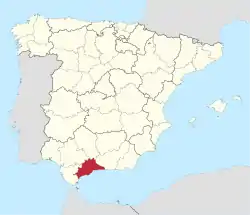 Map of Spain with Málaga highlighted | |
| Coordinates: 36°43′N 4°25′W | |
| Country | Spain |
| Autonomous community | Andalusia |
| Capital | Málaga |
| Government | |
| • President | Francisco Salado (PP) |
| Area | |
| • Total | 7,308 km2 (2,822 sq mi) |
| • Rank | Ranked 35th |
| Population (2013) | |
| • Total | 1,652,999[1] |
| • Rank | Ranked 6th |
| Demonym(s) | Spanish: Malagueño, Malacitano |
| Official language(s) | Spanish |
| Parliament | Cortes Generales |
| Website | malaga.es |
 | |
| Click on the map for a fullscreen view | |
Overview
Its area is 7,308 square kilometres (2,822 sq mi) and its population is 1,652,999 (2013), which is concentrated mainly in the metropolitan area of Málaga, province capital, and throughout the coastal area. The population density surpasses both the Andalusia and Spanish averages, reaching 222.53 inhabitants/km2. Málaga contains 102 municipalities. Besides the capital, its main cities are Marbella, Mijas, Fuengirola, Vélez-Málaga, Torremolinos, Estepona, and Benalmádena, all in the coastal zone. The towns of Antequera and Ronda are located in the interior.
The prevailing climate is a warm Mediterranean with dry and warm, long summers with short, mild winters. The geographical relief varies greatly from zone to zone. In general, the coastal zone has a subtropical Mediterranean climate. To the north, a continental Mediterranean climate exists with cold, dry winters and warm summers.
Its main industry and claim to fame is its tourist resorts, particularly those on the beaches along the Costa del Sol. These beaches are visited by millions of European tourists; other attractions include the gorge of El Chorro near Álora, El Torcal de Antequera, the Moorish-Mudéjar district of Frigiliana, the Dolmen of Menga, and the Caves of Nerja.
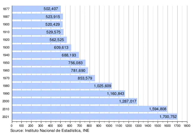
Population development
The historical population is given in the following chart:
Regions
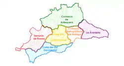
- Málaga
- Costa del Sol
- Valle del Guadalhorce
- Axarquía
- Serranía de Ronda
- Antequera
Protected areas
- Los Alcornocales Natural Park
- Sierra de las Nieves National Park
- Montes de Málaga Natural Park
- Sierras of Tejeda, Almijara and Alhama Natural Park
See also
- List of municipalities in Málaga
References
- Population Figures referring to Municipal Register 1 January 2013 Archived 6 October 2014 at the Wayback Machine - Instituto Nacional de Estadística
External links
- The Caminito del Rey tourist information in English
- Video about Malaga province
- Malaga Metropolitan Transport Consortium Website
- Malaga Tourism (in English)
Municipalities of the province of Málaga | ||
|---|---|---|
| ||