Anexo:Registro Nacional de Lugares Históricos en el Bronx
Esta lista incluye 64 propiedades y distritos listados en el Registro Nacional de Lugares Históricos en el borough del Bronx, Nueva York.[1]
Esta lista proveída por el Servicio de Parques Nacionales está completa según el listado reciente del Registro Nacional de Lugares Históricos entregados el 7 de septiembre de 2012.
Lista de propiedades
| [2] | Nombre | imagen | Fecha listada | Dirección | Localidad | Resumen |
|---|---|---|---|---|---|---|
| 1 | Estación Van Cortlandt Park–Calle 242 | 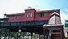 Estación Van Cortlandt Park–Calle 242 |
30 de marzo de 2005 | Encima de Broadway en el cruce de W. 242nd St. 40°53′20″N 73°53′56″O |
El Bronx | |
| 2 | 48th Police Precinct Station | 6 de mayo de 1983 | 1925 Bathgate Ave. 40°50′49″N 73°53′52″O |
El Bronx | ||
| 3 | 52nd Police Precinct Station House and Stable | 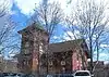 52nd Police Precinct Station House and Stable |
29 de octubre de 1982 | 3016 Webster Ave. 40°52′09″N 73°52′46″O |
Norwood | |
| 4 | Mansión Bartow-Pell y Casa Carriage | 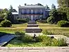 Mansión Bartow-Pell y Casa Carriage |
30 de diciembre de 1974 | Pelham Bay Park, Shore Rd. 40°52′18″N 73°48′21″O |
Pelham Bay Park | |
| 5 | Palacio de Justicia del Borough del Bronx | 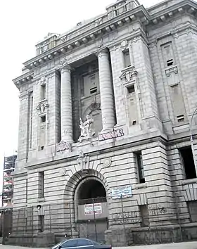 Palacio de Justicia del Borough del Bronx |
25 de febrero de 1982 | E. 161st St., 3rd y Brook Aves. 40°49′22″N 73°54′38″O |
Melrose | |
| 6 | Oficina Postal del Bronx | 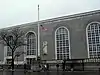 Oficina Postal del Bronx |
6 de mayo de 1980 | 558 Grand Concourse 40°49′08″N 73°55′37″O |
Bronx | |
| 7 | Palacio de Justicia del Condado de Bronx | 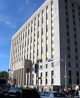 Palacio de Justicia del Condado de Bronx |
8 de septiembre de 1983 | 851 Grand Concourse 40°49′34″N 73°55′27″O |
Bronx | |
| 8 | Casa Amadeo, antigua Casa Hernandez | 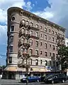 Casa Amadeo, antigua Casa Hernandez |
23 de marzo de 2001 | 786 Prospect Ave. 40°49′09″N 73°54′08″O |
Longwood | |
| 9 | Iglesia de Cristo | 8 de septiembre de 1983 | 5030 Riverdale Ave. 40°53′56″N 73°54′25″O |
Riverdale | ||
| 10 | Casa Robert Colgate | 8 de septiembre de 1983 | 5225 Sycamore Ave. 40°54′07″N 73°54′45″O |
Nueva York | ||
| 11 | Edificios Concourse Yard Entry | 9 de febrero de 2006 | W. 205th St., bet. Jerome and Paul Aves. 40°52′34″N 73°53′21″O |
Kingsbridge | ||
| 12 | Concourse Yard Substation | 9 de febrero de 2006 | 3119 Jerome Ave. 40°52′30″N 73°53′22″O |
Kingsbridge | ||
| 13 | Casa William E. Dodge | 28 de agosto de 1977 | 690 W. 247th St. 40°53′42″N 73°54′56″O |
Nueva York | ||
| 14 | Dollar Savings Bank | 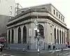 Dollar Savings Bank |
27 de abril de 2011 | 2792 3rd Ave. 40°48′54″N 73°55′08″O |
El Bronx | |
| 15 | Edgehill Church at Spuyten Duyvil | 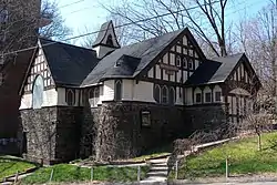 Edgehill Church at Spuyten Duyvil |
29 de octubre de 1982 | 2550 Independence Ave. 40°52′48″N 73°55′13″O |
Spuyten Duyvil | |
| 16 | Eighth Regiment Armory |  Eighth Regiment Armory |
21 de diciembre de 1982 | 29 W. Kingsbridge Rd. 40°52′07″N 73°53′55″O |
Kingsbridge | |
| 17 | Fonthill Castle and the Administration Building of the College of Mount St. Vincent |  Fonthill Castle and the Administration Building of the College of Mount St. Vincent |
11 de julio de 1980 | W. 261st St. and Riverdale Ave. 40°54′49″N 73°54′34″O |
El Bronx | |
| 18 | Fort Schuyler |  Fort Schuyler |
29 de junio de 1976 | Throgs Neck at East River and Long Island Sound 40°48′20″N 73°47′34″O |
Throggs Neck | |
| 19 | Grace Episcopal Church | 13 de septiembre de 2006 | 116 City Island Ave. 40°50′27″N 73°47′04″O |
City Island | ||
| 20 | Distrito histórico de Grand Concourse | 24 de agosto de 1987 | 730-1000, 1100-1520, 1560, and 851-1675 Grand Concourse 40°49′52″N 73°55′26″O |
El Bronx | ||
| 21 | Hall of Fame Complex | 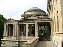 Hall of Fame Complex |
7 de septiembre de 1979 | Bronx Community College campus 40°51′31″N 73°54′52″O |
University Heights | |
| 22 | Hertlein and Schlatter Silk Trimmings Factory | 5 de febrero de 2001 | 454-464 E. 148th St. 40°48′51″N 73°54′59″O |
Mott Haven | ||
| 23 | High Pumping Station | 10 de noviembre de 1983 | Jerome Ave. 40°52′42″N 73°53′12″O |
Nueva York | ||
| 24 | House at 175 Belden Street | 3 de junio de 1982 | 175 Belden St. 40°50′17″N 73°46′57″O |
Nueva York | ||
| 25 | Jackson Avenue Station | 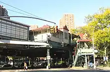 Jackson Avenue Station |
17 de septiembre de 2004 | Cruce de E. 152nd St. and Jackson and Westchester Aves. 40°49′00″N 73°54′29″O |
El Bronx | |
| 26 | Jerome Park Reservoir |  Jerome Park Reservoir |
7 de septiembre de 2000 | Goulden, Reservoir and Sedgwick Aves. 40°52′40″N 73°53′44″O |
El Bronx | |
| 27 | Keeper's House at Williamsbridge Reservoir | 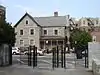 Keeper's House at Williamsbridge Reservoir |
24 de septiembre de 1999 | 3400 Reservoir Oval 40°52′43″N 73°52′34″O |
El Bronx | |
| 28 | Lisanti Chapel | 11 de enero de 2002 | 740 E. 215th St. 40°52′48″N 73°51′48″O |
El Bronx | ||
| 29 | Distrito histórico de Longwood (Bronx) | 26 de septiembre de 1983 | Bordeada por Beck St., Longwood, Leggett, and Prospect Aves. 40°49′00″N 73°54′00″O |
Nueva York | ||
| 30 | Lorillard Snuff Mill | 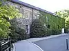 Lorillard Snuff Mill |
22 de diciembre de 1977 | Off U.S. 1 40°51′36″N 73°52′35″O |
Bronx Botanical Gardens | |
| 31 | Distrito histórico de Morris High School | 15 de septiembre de 1983 | Bordeada por Boston Rd., Jackson y Forrest Aves., y E. 166th y Home Sts. 40°49′38″N 73°54′15″O |
Morrisania | ||
| 32 | Morris Park Station | 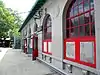 Morris Park Station |
6 de julio de 2005 | Bajo Espalanade en Bogart y Colden Ave. y Hone Ave. 40°51′16″N 73°51′40″O |
El Bronx | |
| 33 | Mott Avenue Control House | 6 de mayo de 1980 | 149th St. and Grand Concourse 40°49′07″N 73°55′38″O |
El Bronx | ||
| 34 | Distrito histórico de Mott Haven | 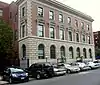 Distrito histórico de Mott Haven |
25 de marzo de 1980 | An irregular pattern along Alexander Ave. and E. 140th St. 40°48′37″N 73°55′32″O |
Mott Haven | |
| 35 | New York Botanical Garden | 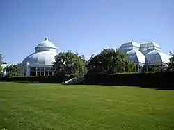 New York Botanical Garden |
28 de mayo de 1967 | Southern and Bedford Park Blvds. 40°51′49″N 73°52′34″O |
Bronx Park | |
| 36 | New York, Westchester and Boston Railroad Administration Building | 23 de abril de 1980 | 481 Morris Park Ave. 40°50′29″N 73°52′23″O |
Nueva York | ||
| 37 | Park Plaza Apartments | 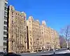 Park Plaza Apartments |
3 de junio de 1982 | 1005 Jerome Ave. 40°49′50″N 73°55′30″O |
Nueva York | |
| 38 | Pelham Parkway Station | 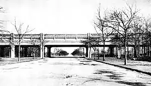 Pelham Parkway Station |
30 de marzo de 2005 | Cruce de White Plains Rd. and Pelham Pkwy 40°51′26″N 73°52′03″O |
El Bronx | |
| 39 | Poe Cottage | 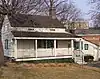 Poe Cottage |
19 de agosto de 1980 | 2640 Grand Concourse 40°51′55″N 73°53′40″O |
El Bronx | |
| 40 | Prospect Avenue Station | Prospect Avenue Station |
17 de septiembre de 2004 | Cruce de Westchester and Lonwood Aves. and Prospect St. 40°49′11″N 73°54′08″O |
El Bronx | |
| 41 | Public School 11 | 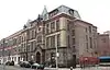 Public School 11 |
8 de septiembre de 1983 | 1257 Ogden Ave. 40°50′23″N 73°55′35″O |
El Bronx | |
| 42 | Public School 15 | 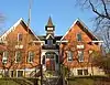 Public School 15 |
10 de diciembre de 1981 | 4010 Dyre Ave. 40°53′27″N 73°49′52″O |
Eastchester | |
| 43 | Public School 17 | 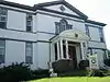 Public School 17 |
27 de septiembre de 1984 | 190 Fordham St. 40°50′49″N 73°47′05″O |
City Island | |
| 44 | Rainey Memorial Gates | 16 de marzo de 1972 | New York Zoological Park 40°51′18″N 73°52′40″O |
El Bronx | ||
| 45 | C. Rieger's Sons Factory | 27 de mayo de 2004 | 450-452 E. 148th St. 40°48′51″N 73°55′01″O |
Mott Haven | ||
| 46 | Riverdale–Spuyten Duyvil–Kingsbridge Memorial Bell Tower | 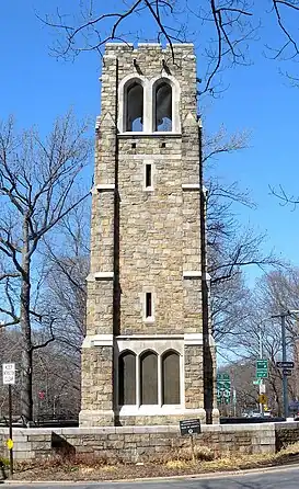 Riverdale–Spuyten Duyvil–Kingsbridge Memorial Bell Tower |
3 de enero de 2012 | Riverdale Ave. at W. 239th St. & Henry Hudson Pkwy. 40°53′21″N 73°54′30″O |
El Bronx | |
| 47 | Riverdale Presbyterian Church Complex | 14 de octubre de 1982 | 4761-4765 Henry Hudson Parkway 40°53′45″N 73°54′32″O |
Riverdale | ||
| 48 | St. Ann's Church Complex | 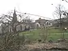 St. Ann's Church Complex |
16 de abril de 1980 | 295 St. Ann's Ave. 40°48′30″N 73°55′03″O |
South Bronx | |
| 49 | St. James' Episcopal Church and Parish House | 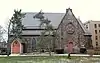 St. James' Episcopal Church and Parish House |
30 de septiembre de 1982 | 2500 Jerome Ave. 40°51′50″N 73°54′00″O |
El Bronx | |
| 50 | St. Peter's Church, Chapel and Cemetery Complex | 26 de septiembre de 1983 | 2500 Westchester Ave. 40°50′17″N 73°50′41″O |
El Bronx | ||
| 51 | St. Stephen's Methodist Church | 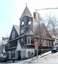 St. Stephen's Methodist Church |
8 de febrero de 2012 | 146 W. 228th St. 40°52′37″N 73°54′33″O |
El Bronx | |
| 52 | Simpson Street Station | 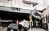 Simpson Street Station |
17 de septiembre de 2004 | Cruce de Westchester Ave. entre Simpson St. y Southern Blvd. 40°49′27″N 73°53′37″O |
El Bronx | |
| 53 | Henry F. Spaulding Coachman's House | 4 de noviembre de 1982 | 4970 Independence Ave. 40°53′53″N 73°54′41″O |
El Bronx | ||
| 54 | Sunnyslope | 15 de septiembre de 1983 | 812 Faile St. 40°49′02″N 73°53′14″O |
El Bronx | ||
| 55 | Tremont Baptist Church | 16 de octubre de 2009 | 324 E. Tremont Ave. 40°50′54″N 73°54′08″O |
Tremont | ||
| 56 | United Workers Cooperatives | 11 de septiembre de 1986 | 2700-2870 Bronx Park E 40°51′59″N 73°52′11″O |
Hunts Point | ||
| 57 | US Post Office-Morrisania | 17 de noviembre de 1988 | 442 E. 167th St. 40°49′47″N 73°54′34″O |
Morrisania | ||
| 58 | Casa Valentine-Varian | 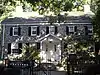 Casa Valentine-Varian |
21 de marzo de 1978 | 3266 Bainbridge Ave. 40°52′38″N 73°52′47″O |
Norwood | |
| 59 | Casa Frederick Van Cortlandt | 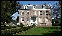 Casa Frederick Van Cortlandt |
24 de diciembre de 1967 | Van Cortlandt Park at 242nd St. 40°53′40″N 73°53′35″O |
El Bronx | |
| 60 | Puente de Washington | 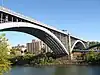 Puente de Washington |
22 de septiembre de 1983 | Entre Ámsterdam y Undercliff Aves. 40°50′42″N 73°55′29″O |
El Bronx | |
| 61 | Wave Hill | 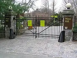 Wave Hill |
9 de septiembre de 1983 | 675 W. 252nd St. 40°53′55″N 73°54′47″O |
Riverdale | |
| 62 | Estación Westchester Square (Dual System IRT) | 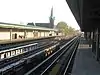 Estación Westchester Square (Dual System IRT) |
30 de marzo de 2005 | Arriba de Westchester Ave., desde Overing St. a Ferris Place 40°50′23″N 73°50′38″O |
El Bronx | |
| 63 | Cementero Woodlawn | 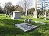 Cementero Woodlawn |
23 de junio de 2011 | Webster Avenue & East 233rd Street 40°53′43″N 73°51′49″O |
El Bronx | |
| 64 | Estación Woodlawn (Dual System IRT) | 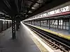 Estación Woodlawn (Dual System IRT) |
6 de julio de 2005 | Cruce de Bainbridge Ave. and Jerome Ave. 40°53′09″N 73°52′45″O |
El Bronx |
Véase también
Referencias
- La información de la latitud y longitud proveída en esta tabla fue obtenida originalmente por el Sistema de Información del Registro Nacional de Lugares Históricos, que ha sido verás el 99% de las veces. El 1% de las coordenadas de la NRIS, podrían tener pequeños errores, pero no lejos de su localidad; algunas correcciones se han hecho. Un problema más sutil causa que muchos lugares estén a un máximo de 150 yardas, de su ubicación original, dependiendo de la ubicación en el país: la mayoría de las coordenadas de la NRIS fueron obtenidas de mapas de cuadrantes topográficos de la USGS creados bajo Fecha de utilidad de conversión de América del Norte de 1927, en la cual difiere, de los sistemas actuales GPS usados por Google mapas.
- Numbers represent an ordering by significant words. Various colorings, defined here, differentiate National Historic Landmarks and historic districts from other NRHP buildings, structures, sites or objects.
Enlaces externos
 Wikimedia Commons alberga una categoría multimedia sobre Registro Nacional de Lugares Históricos en el Bronx.
Este artículo ha sido escrito por Wikipedia. El texto está disponible bajo la licencia Creative Commons - Atribución - CompartirIgual. Pueden aplicarse cláusulas adicionales a los archivos multimedia.