District de Vöcklabruck

Le district de Vöcklabruck se rattache à la Haute-Autriche. Il forme une partie du Hausruckviertel.

Vöcklabruck

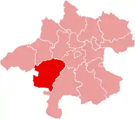
Localisation du district de Vöcklabruck dans le Land autrichien de Haute-Autriche.
Administration
Pays Autriche
Land  Haute-Autriche
Centre administratif Vöcklabruck
Immatriculation VB
Démographie
Population 126 599 hab. (15 mai 2001)
Densité 117 hab./km2
Géographie
Coordonnées 48° 00′ 32″ nord, 13° 34′ 30″ est
Superficie 108 426 ha = 1 084,26 km2
Localisation
Géolocalisation sur la carte : Autriche

    Organisation administrative

    Le district de Vöcklabruck regroupe 52 communes et 4 juridictions (Vöcklabruck, Schwanenstadt, Frankenmarkt et Mondsee).

    Villes

    1. Vöcklabruck (11 715)
    2. Attnang-Puchheim (8 782)
    3. Schwanenstadt (4 143)

    Villes de foire

    1. Ampflwang im Hausruckwald (3 613)
    2. Frankenburg am Hausruck (5 110)
    3. Frankenmarkt (3 508)
    4. Lenzing (5 049)
    5. Mondsee (3 207)
    6. Regau (5 495)
    7. Schörfling am Attersee (3 170)
    8. Seewalchen am Attersee (4 761)
    9. Sankt Georgen im Attergau (4 032)
    10. Timelkam (5 812)
    11. Vöcklamarkt (4.765)
    12. Wolfsegg am Hausruck (1.983)

    communes

    1. Attersee am Attersee (1.496)
    2. Atzbach (1.154)
    3. Aurach am Hongar (1.585)
    4. Berg im Attergau (990)
    5. Desselbrunn (1.534)
    6. Fornach (863)
    7. Gampern (2.472)
    8. Innerschwand (1.050)
    9. Manning (829)
    10. Neukirchen an der Vöckla (2.530)
    11. Niederthalheim (1.076)
    12. Nußdorf am Attersee (1.096)
    13. Oberhofen am Irrsee (1.335)
    14. Oberndorf bei Schwanenstadt (1.351)
    15. Oberwang (1.572)
    16. Ottnang am Hausruck (3.745)
    17. Pfaffing (1.372)
    18. Pilsbach (630)
    19. Pitzenberg (495)
    20. Pöndorf (2.232)
    21. Puchkirchen am Trattberg (948)
    22. Pühret (573)
    23. Redleiten (465)
    24. Redlham (1.309)
    25. Rüstorf (1.988)
    26. Rutzenham (236)
    27. Schlatt (1.338)
    28. Sankt Lorenz (2.010)
    29. Steinbach am Attersee (913)
    30. Straß im Attergau (1.481)
    31. Tiefgraben (3.071)
    32. Ungenach (1.349)
    33. Unterach am Attersee (1.496)
    34. Weißenkirchen im Attergau (964)
    35. Weyregg am Attersee (1.503)
    36. Zell am Moos (1.390)
    37. Zell am Pettenfirst (1.223)

    (Tous les chiffres de pop. au 15 mai 2001)

    Carte interactive des communes du district de Vöcklabruck

    Notes et références

      Liens externes

      • Portail de l'Autriche
      Cet article est issu de Wikipedia. Le texte est sous licence Creative Commons - Attribution - Partage dans les Mêmes. Des conditions supplémentaires peuvent s'appliquer aux fichiers multimédias.