Ozamiz
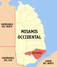
Ozamiz est une ville des Philippines de la partie sud de la province de Misamis occidental.
Ozamiz

| Nom officiel |
(en) City of Ozamiz |
|---|
| Pays | |
|---|---|
| Groupe d'îles |
Mindanao (en) |
| Région | |
| Province | |
| Partie de | |
| Superficie |
169,95 km2 |
| Altitude |
216 m |
| Coordonnées |
8° 09′ N, 123° 51′ E |

| Population |
140 334 hab. () |
|---|---|
| Nombre de ménages |
29 626 () |
| Densité |
825,7 hab./km2 () |
| Électorat |
85 534 |
| Statut |
Component city (en) |
|---|---|
| Jumelage |
| Origine du nom |
José Ozámiz (en) |
|---|---|
| Fondation |
| Code postal |
7200 |
|---|---|
| TGN | |
| Indicatif téléphonique |
88 |
| Site web |
(en) ozamizcity.com |

La ville est située près des provinces de Zamboanga du Sud et du Nord, à 52 km des chutes Maria Cristina (en), principale source d'hydroélectricité du Mindanao.
Divisions administratives
Ozamiz est divisée en 51 barangays.
| Barangays | District | Population (2010) |
Superficie (km²)[1] | Densité (/km²) |
|---|---|---|---|---|
| Aguada (Pob.) | 7 196 | 2,6306 | 2 735 | |
| Banadero (Pob.) | 8 460 | 1,9408 | 4 359 | |
| Bacolod | 1 856 | 1,6103 | 1 152 | |
| Bagakay | 3 511 | 3,8073 | 922 | |
| Balintawak | 620 | 3,9151 | 158 | |
| Baybay Santa Cruz | 1 875 | ,0172 | 109 011 | |
| Baybay Triunfo | 2 487 | ,0779 | 31 925 | |
| Bongbong | 2 030 | ,1095 | 18 538 | |
| Calabayan | 3 195 | 1,9117 | 1 671 | |
| Capucao C. | 515 | 2,9975 | 171 | |
| Capucao P. | 1 486 | 2,3482 | 632 | |
| Carangan | 3 781 | 6,4895 | 582 | |
| Catadman-Manabay | 7 075 | ,2653 | 23 667 | |
| Cavinte | 585 | ,3347 | 1 747 | |
| Cogon | 1 262 | 4,0359 | 312 | |
| Dalapang | 516 | 4,2783 | 120 | |
| Diguan | 1 451 | 3,0340 | 478 | |
| Dimaluna | 2 692 | 3,4494 | 780 | |
| Embargo | 879 | ,8332 | 1 054 | |
| Gala | 859 | 2,4202 | 353 | |
| Gango | 5 097 | 5,4638 | 932 | |
| Gotokan Daku | 433 | 3,1795 | 136 | |
| Gotokan Diot | 458 | 1,8278 | 250 | |
| Guimad | 528 | 1,8485 | 285 | |
| Guingona | 445 | 3,0311 | 146 | |
| Kinuman Norte | 1 362 | 2,7165 | 501 | |
| Kinuman Sur | 1 132 | 7,8017 | 145 | |
| Labinay | 1 635 | 7,2654 | 225 | |
| Labo | 2 600 | 6,8165 | 381 | |
| Lam-an | 3 376 | 4,3820 | 770 | |
| Liposong | 749 | ,5054 | 1 481 | |
| Litapan | 892 | 2,8745 | 310 | |
| Malaubang | 6 528 | 3,3998 | 1 920 | |
| Manaka | 737 | 1,5667 | 470 | |
| Maningcol | 7 518 | 4,8360 | 1 554 | |
| Mentering | 352 | 1,8414 | 191 | |
| Carmen Annex | 6 233 | 2,4761 | 2 517 | |
| Molicay | 3 076 | 1,0743 | 2 863 | |
| Stimson Abordo (Montol) | 2 192 | |||
| Pantaon | 870 | 3,0859 | 282 | |
| Pulot | 3 514 | 3,4218 | 1 026 | |
| San Antonio | 3 818 | ,9977 | 3 826 | |
| Baybay San Roque | 3 475 | |||
| Sangay Daku | 809 | 7,3126 | 110 | |
| Sangay Diot | 380 | 2,8685 | 132 | |
| Sinuza | 1 490 | 4,8623 | 306 | |
| Tabid | 3 651 | 6,1632 | 592 | |
| Tinago | 10 244 | ,3196 | 32 052 | |
| Trigos | 698 | 9,5759 | 72 | |
| 50e District (Pob.) | 1 553 | ,1252 | 12 404 | |
| Doña Consuelo | 3 351 | 6,1729 | 542 |
Démographie
| Population of | |||||||||||||||||||||||||||||||||||||||||||||||||
|---|---|---|---|---|---|---|---|---|---|---|---|---|---|---|---|---|---|---|---|---|---|---|---|---|---|---|---|---|---|---|---|---|---|---|---|---|---|---|---|---|---|---|---|---|---|---|---|---|---|
|
| ||||||||||||||||||||||||||||||||||||||||||||||||
| Sources : Philippine Statistics Authority[2],[3],[4],[5] | |||||||||||||||||||||||||||||||||||||||||||||||||
Notes et références
- (en) Cet article est partiellement ou en totalité issu de l’article de Wikipédia en anglais intitulé « Ozamiz » (voir la liste des auteurs).
- (en) « City Barangays: Land Area by Barangay and Road Distance from City of Ozamis City Hall »(Archive.org • Wikiwix • Archive.is • Google • Que faire ?), sur Ozamizcity.com, Eddie A. Artajo (consulté le )
- (en) Census of Population (2015), « Total Population by Province, City, Municipality and Barangay », dans Census of Population (2015), Total Population by Province, City, Municipality and Barangay, « Region X (Northern Mindanao) » (consulté le )
- (en) Census of Population and Housing (2010), « Total Population by Province, City, Municipality and Barangay », dans Census of Population and Housing (2010), Total Population by Province, City, Municipality and Barangay, « Region X (Northern Mindanao) » (consulté le )
- (en) Census of Population (1995, 2000 and 2007), « Total Population by Province, City and Municipality », dans Census of Population (1995, 2000 and 2007), Total Population by Province, City and Municipality (lire en ligne [archive du ]), « Region X (Northern Mindanao) »
- (en) Municipality Population Data, « Province de Misamis Occidental », Local Water Utilities Administration (en) Research Division (consulté le )
Cet article est issu de Wikipedia. Le texte est sous licence Creative Commons - Attribution - Partage dans les Mêmes. Des conditions supplémentaires peuvent s'appliquer aux fichiers multimédias.