Concept
Version 15
Created by Boundless
Land Policy under the Confederation

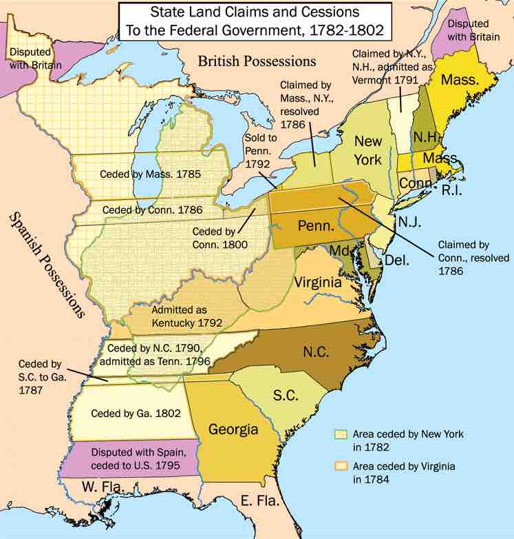
United States Land Claims and Cessions, 1782–1802
Illustration of the state cessions that eventually allowed for the creation of the territories north and west of the River Ohio.
This map shows that a portion of Minnesota and northern Maine were disputed with Britain; a large area covering Indiana, Ohio, West Virginia, and portions of Michigan, Illinois, Kentucky, and Tennessee was ceded by New York in 1782; a large area covering portions of Minnesota, Wisconsin, Michigan, and Illinois was ceded by Virginia in 1784; portions of Wisconsin and Michigan were ceded by Massachusetts in 1785; portions of Ohio, Michigan, Indiana, and Illinois were ceded by Connecticut in 1786; northern Pennsylvania was claimed by Connecticut, but the dispute was resolved in 1786; a portion of western New York was claimed by Massachusetts, but the dispute was resolved in 1786; portions of northern Georgia, Alabama, and Mississippi were ceded by South Carolina to Georgia in 1787; Tennessee was ceded by North Carolina in 1790 and admitted as a state in 1796; Vermont was claimed by both New York and New Hampshire, but was admitted as a state in 1791; Kentucky was admitted as a state in 1792; the western tip of New York was sold to Pennsylvania in 1792; portions of southern Alabama and Mississippi were disputed with Spain and ceded to the United States in 1795; northeastern Ohio was ceded by Connecticut in 1800, and portions of northern Alabama and Mississippi were ceded by Georgia in 1802.
Source
Boundless vets and curates high-quality, openly licensed content from around the Internet. This particular resource used the following sources:
"United_States_land_claims_and_cessions_1782-1802.png."
https://en.wikipedia.org/wiki/Northwest_Territory%23/media/File:United_States_land_claims_and_cessions_1782-1802.png
Wikipedia
CC BY-SA 2.5.