Map of North America after the Treaty of Paris
The map shows major territorial concessions following the Treaty of Paris. Disputes arising over the failure of British troops to leave some of the territories ceded by the British in the Treaty of Paris, as well as British instigation of conflicts between Native Americans and the newly established United States, ultimately contributed to the need for Jay's Treaty in 1796.
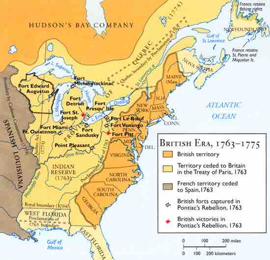
This map shows British territory, covering the 13 original colonies of the United States as well as portions of Ontario and Quebec; territory ceded to Britain in the Treaty of Paris, 1763, covering eastern Canada and a large portion of the Midwestern United States; French territory ceded to Spain, 1763, covering lands west of the Mississippi River; British forts captured in Pontiac’s Rebellion, including (from west to east) Fort Ouiatenon, Fort St. Joseph, Fort Michilimackinac, Fort Miami, Fort Sandusky, Point Pleasant, Fort Presqu’ Isle, Fort Vonango, and Port Le Boeuf; and British victories in Pontiac’s Rebellion, 1763, including (from west to east) Fort Detroit and Fort Pitt.
Source
Boundless vets and curates high-quality, openly licensed content from around the Internet. This particular resource used the following sources:
"Teaching Modules."
http://theomahaproject.org/module_display.php?mod_id=74&review=yes
The Omaha Project
Public domain.