The lithosphere

   1. The relief

   it is the form that the surface of the earth's crust has.

   The earth's crust has not always had the actual form. Some current plains were under the sea many years ago.


   2. Relief forms

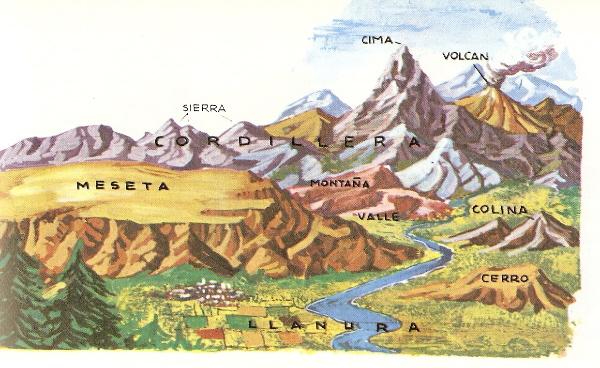
   The main forms are: mountains, plateaus, plains and depressions.
   - Mountain is a great land elevation. The highest part of the mountain is called summit and its inclination is called slope.
   When the mountains are aligned, they form a mountain chain. For example: the Andes.
   There are young and old mountains. The first ones are usually high and are distinguished by their acute forms, their large peaks and steep slopes. For example: The Pyrenees.
   The second ones are usually not very high and are distinguished by their erode forms because of the erosion. For example: the Galician Massif in Galicia, Spain.
   - Plateaus are flat elevated regions. The Spanish Central Plateau has about 600 meters high. There are plateaus as high as the highest mountain. For example: the Tibet, called the “Roof of the World ", has more than 5 000 meters high.
   The plateaus are usually old erode mountains.
   - Plains are flat regions but its altitude does not exceed 200 meters above sea level. There are plains that occupy several million square kilometers. For example: the plains of central Europe and northern Asia.
   The plains are usually dried depths of ancient seas.
   - Basins are areas that are below sea level as a result of land subsidence. For example: "Death Valley" in California and “Dead Sea" in Palestine.
   - The valleys are sunken areas.


   3. Choose one of these words and answer: mountain, plateau, plain or basin

They are high and flat lands

Great land elevation

Areas below sea level

Flat areas with few elevations

They form the Andes

They are erode old mountains

Depths of ancient seas

It is because of land subsidence

The Tibet

The Pyrenees

In central Europe

The Dead Sea

The Galician massif

The Death Valley


    4. Internal factors

   The Earth's surface still suffers modifications, although they occur very slowly. This evolution of the relief is caused by internal and external factors. The most prominent are:
   - Sedimentation of materials in the sea because of the drag of stones and soil by the rivers and the erosion. Sediments are coming together at the depth of the sea and cause that it sinks slowly. (See figure 1).
   - Fold (see Figure 2). The lateral pressures cause contraction and wrinkling of the sediments causing the folds. The high pressures determined the elevation of flexible materials of the earth's crust. They form mountain chains. For example: the Pyrenees in Spain.
   - Fault (see figure 3). When materials of the region were very rigid, they fractured being unable to fold. The results of this phenomenon are faults. They usually form large massifs. For example: the Sierra Morena, in Spain.


   5. Choose one of these words and answer: sedimentation, fold or fault:

Sediments fold

Accumulation of material in the sea

Earth layers fracture

It sinks into the sea

The Pyrenees

The Sierra Morena


   6. External factors

   The Earth's surface is also modified by external factors: rivers, sea water, wind and ice.
   - Rivers have three functions: the erosion with the destruction of rocks in the high course. Ravines produce gullies. The transport of materials in the middle course and the sedimentation in the low course, leaving materials in the sea.
   - Seawaters: the sea has a great destructive force because of the power of the waves that crash against coastal rocks and destroy them. Ocean currents also sweep along the materials thrown by rivers or pulling by the waves.
   - The wind carries sand and other small particles that collide with rocks. Wind can also form accumulations of sand like the dunes.
   - Ice: When water accumulates in the crevices of the rock and freezes, it increases its volume and works as a wedge, which eventually ends up blowing up whole rocks. Glaciers also produce erosion in the mountains.


   7. Choose one of these words and answer: rivers, seawater, wind or ice:

The sand collides with the rocks

Ravines produce gullies

Waves collide with the rocks

It works as Wedges

It destroys rocks in the high course

The currents sweep along materials

It can form dunes

Glaciers cause erosion


If you are registered, please enter your data
 
Name:

Password:


Registration Information

| Educational applications | Geography
 In Spanish  | To print  |  Google Map |

®Arturo Ramo García.-Record of intellectual property of Teruel (Spain) No 141, of 29-IX-1999
Plaza Playa de Aro, 3, 1º DO 44002-TERUEL