Ököritófülpös
Ököritófülpös is a village in Szabolcs-Szatmár-Bereg county, in the Northern Great Plain region of eastern Hungary.
Ököritófülpös | |
|---|---|
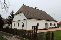
 The vicarage of the Reformed church in Ököritófülpös | |
 Flag  Coat of arms | |
| Country | |
| County | Szabolcs-Szatmár-Bereg |
| Area | |
| • Total | 33.43 km2 (12.91 sq mi) |
| Population (2001) | |
| • Total | 2,015 |
| • Density | 60.28/km2 (156.1/sq mi) |
| Time zone | UTC+1 (CET) |
| • Summer (DST) | UTC+2 (CEST) |
| Postal code | 4755 |
| Area code | 44 |

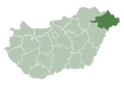
Location of Szabolcs-Szatmar-Bereg county in Hungary
Location
It is located in eastern region of the county on the Szatmári plain. Today the entire settlement lies on the left bank of the Szamos, but before the regulation of the river, only the present-day Ököritó and Mácsa settlement parts fell on the left bank, Fülpös was on the other side. The former river section that divided the present-day settlement into separate parts is now a backwater, which winds from Cégénydányád almost all the way to the border of Nábrád , approximately 25 kilometers long.
Geography
It covers an area of 33.43 km2 (13 sq mi) and has a population of 2015 people (2001).
References
- "OFM's bureaucratic bungling on barn party issue leaves everyone scratching their heads". New Hamburg Independent. Retrieved 27 March 2014.
This article is issued from Wikipedia. The text is licensed under Creative Commons - Attribution - Sharealike. Additional terms may apply for the media files.

