Česká Čermná
Česká Čermná is a municipality and village in Náchod District in the Hradec Králové Region of the Czech Republic. It has about 500 inhabitants.
Česká Čermná | |
|---|---|
 Municipal office | |
 Flag  Coat of arms | |
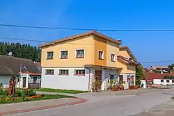
 Česká Čermná Location in the Czech Republic | |
| Coordinates: 50°24′3″N 16°13′46″E | |
| Country | |
| Region | Hradec Králové |
| District | Náchod |
| First mentioned | 1448 |
| Area | |
| • Total | 8.92 km2 (3.44 sq mi) |
| Elevation | 520 m (1,710 ft) |
| Population (2023-01-01)[1] | |
| • Total | 505 |
| • Density | 57/km2 (150/sq mi) |
| Time zone | UTC+1 (CET) |
| • Summer (DST) | UTC+2 (CEST) |
| Postal code | 549 21 |
| Website | www |
Geography
Česká Čermná is located about 4 kilometres (2 mi) east of Náchod and 34 km (21 mi) northeast of Hradec Králové, on the border with Poland. It lies in the Orlické Foothills. The highest point is the hill Kašparka at 639 m (2,096 ft) above sea level.
History
The first written mention of Česká Čermná is from 1448. Until 1849, it belonged to the Náchod estate and shared its owners.[2]
Transport
There is the Česká Čermná / Brzozowie road border crossing with Poland.
Sights
There are no protected cultural monuments.[3] The only landmark of Česká Čermná is the Chapel of Saint Wenceslaus. It is a modern chapel, built in 1938–1939.[4]
References
- "Population of Municipalities – 1 January 2023". Czech Statistical Office. 2023-05-23.
- "Historie obce" (in Czech). Obec Česká Čermná. Retrieved 2023-04-06.
- "Výsledky vyhledávání: Kulturní památky, okres Náchod". Ústřední seznam kulturních památek (in Czech). National Heritage Institute. Retrieved 2023-04-06.
- "Kaple svatého Václava v České Čermné" (in Czech). Náchod Deanery. Retrieved 2023-04-06.
This article is issued from Wikipedia. The text is licensed under Creative Commons - Attribution - Sharealike. Additional terms may apply for the media files.