Česká Lípa District
Česká Lípa District (Czech: okres Česká Lípa) is a district in the Liberec Region of the Czech Republic. Its capital is the town of Česká Lípa.
Česká Lípa District
Okres Česká Lípa | |
|---|---|
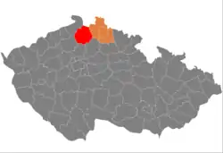 Location in the Liberec Region within the Czech Republic | |
 | |
| Coordinates: 50°39′N 14°38′E | |
| Country | |
| Region | Liberec |
| Capital | Česká Lípa |
| Area | |
| • Total | 1,072.87 km2 (414.24 sq mi) |
| Population (2023)[2] | |
| • Total | 103,344 |
| • Density | 96/km2 (250/sq mi) |
| Time zone | UTC+1 (CET) |
| • Summer (DST) | UTC+2 (CEST) |
| Municipalities | 57 |
| * Towns | 11 |
| * Market towns | 1 |
Administrative division
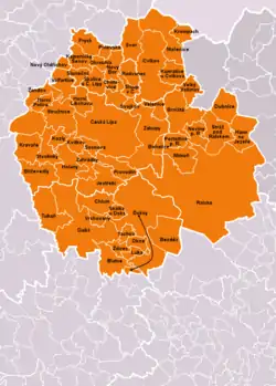
Česká Lípa District is divided into two administrative districts of municipalities with extended competence: Česká Lípa and Nový Bor.
List of municipalities
Towns are marked in bold and market towns in italics:
Bezděz - Blatce - Blíževedly - Bohatice - Brniště - Česká Lípa - Chlum - Chotovice - Cvikov - Doksy - Dubá - Dubnice - Hamr na Jezeře - Holany - Horní Libchava - Horní Police - Jestřebí - Kamenický Šenov - Kozly - Kravaře - Krompach - Kunratice u Cvikova - Kvítkov - Luka - Mařenice - Mimoň - Noviny pod Ralskem - Nový Bor - Nový Oldřichov - Okna - Okrouhlá - Pertoltice pod Ralskem - Polevsko - Provodín - Prysk - Radvanec - Ralsko - Skalice u České Lípy - Skalka u Doks - Sloup v Čechách - Slunečná - Sosnová - Stráž pod Ralskem - Stružnice - Stvolínky - Svojkov - Svor - Tachov - Tuhaň - Velenice - Velký Valtinov - Volfartice - Vrchovany - Zahrádky - Zákupy - Žandov - Ždírec
Geography
Česká Lípa District briefly borders Germany in the north. The terrain is very diverse, with large differences in altitude, and hilly landscape prevails. The territory extends into four geomorphological mesoregions: Ralsko Uplands (most of the territory), Central Bohemian Uplands (west), Lusatian Mountains (north) and Jizera Table (small part in the southeast). The highest point of the district is the mountain Luž in Mařenice with an elevation of 793 m (2,602 ft), the lowest point is the river bed of the Liběchovka Stream in Dubá at 222 m (728 ft).
From the total district area of 1,072.9 km2 (414.2 sq mi), agricultural land occupies 430.8 km2 (166.3 sq mi), forests occupy 506.6 km2 (195.6 sq mi), and water area occupies 25.8 km2 (10.0 sq mi). Forests cover 47.2% of the district's area.[1]
The most significant river is the Ploučnice, which flows across the district from east to west. Its longest tributary in the district is the Svitávka. The largest body of water is Lake Mácha.
There are three protected landscape areas: Lusatian Mountains, Central Bohemian Uplands and Kokořínsko – Máchův kraj.
Demographics
|
|
| ||||||||||||||||||||||||||||||||||||||||||||||||||||||
| Source: Censuses[3][4] | ||||||||||||||||||||||||||||||||||||||||||||||||||||||||
Most populated municipalities
| Name | Population[2] | Area (km2) |
|---|---|---|
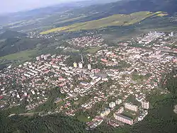
| Česká Lípa | 37,262 | 66 |
| Nový Bor | 11,485 | 19 |
| Mimoň | 6,358 | 15 |
| Doksy | 5,187 | 75 |
| Cvikov | 4,577 | 45 |
| Kamenický Šenov | 3,892 | 10 |
| Stráž pod Ralskem | 3,762 | 22 |
| Zákupy | 2,971 | 41 |
| Ralsko | 2,273 | 170 |
| Žandov | 1,943 | 27 |
Economy
The largest employers with headquarters in Česká Lípa District and at least 500 employees are:[5]
| Economic entity | Location | Number of employees | Main activity |
|---|---|---|---|
| Adient Czech Republic | Česká Lípa | 3,000–3,999 | Automotive industry |
| Diamo | Stráž pod Ralskem | 3,000–3,999 | Landscape rehabilitation and reclamation |
| Fehrer Bohemia | Česká Lípa | 2,000–2,499 | Automotive industry |
| Nemocnice s poliklinikou Česká Lípa | Česká Lípa | 1,000–1,499 | Health care |
| Clarios Česká Lípa | Česká Lípa | 500–999 | Manufacture of batteries |
| Grammer Automotive CZ | Česká Lípa | 500–999 | Automotive industry |
Transport
There are no motorways in the district territory. The most important roads that pass through the district are the I/13 (part of the European route E442) from Liberec to Karlovy Vary, and the I/9 from Prague to the Czech-German border via Česká Lípa.
Sights

The most important monuments in the district, protected as national cultural monuments, are:[6]
- Bezděz Castle
- Zákupy Castle
- Pilgrimage complex with the Church of the Visitation of the Virgin Mary in Horní Police
The best-preserved settlements and landscapes, protected as monument reservations and monument zones, are:[7]
- Janovice (monument reservation)
- Lhota (monument reservation)
- Rané (monument reservation)
- Žďár (monument reservation)
- Česká Lípa
- Dubá
- Kamenický Šenov
- Nový Bor
- Zákupy
- Bukovec
- Kravaře
- Kruh
- Pavlovice
- Sloup v Čechách
- Tubož
- Velenice
- Vojetín
- Zahrádecko landscape
The most visited tourist destinations are the Bezděz Castle and Sloup Castle.[8]
Notable people
References
- "Land use (as at 31 December)". Public database. Czech Statistical Office. Retrieved 2023-05-18.
- "Population of Municipalities – 1 January 2023". Czech Statistical Office. 2023-05-23.
- "Historický lexikon obcí České republiky 1869–2011 – Okres Česká Lípa" (in Czech). Czech Statistical Office. 2015-12-21. pp. 1–2.
- "Population Census 2021: Population by sex". Public Database. Czech Statistical Office. 2021-03-27.
- "Registr ekonomických subjektů". Business Register (in Czech). Czech Statistical Office. Retrieved 2023-04-03.
- "Výsledky vyhledávání: Národní kulturní památky, okres Česká Lípa". Ústřední seznam kulturních památek (in Czech). National Heritage Institute. Retrieved 2023-04-03.
- "Výsledky vyhledávání: Památkové rezervace, Památkové zóny, okres Česká Lípa". Ústřední seznam kulturních památek (in Czech). National Heritage Institute. Retrieved 2023-04-03.
- "Turisté mají v České republice nejraději zoologické zahrady, technické památky, koupání a Pražský hrad" (in Czech). CzechTourism. 2022-06-24. Retrieved 2023-04-03.
External links
- Česká Lípa District – profile on the Czech Statistical Office website