Jablonec nad Nisou District
Jablonec nad Nisou District (Czech: okres Jablonec nad Nisou) is a district in the Liberec Region of the Czech Republic. Its capital is the city of Jablonec nad Nisou.
Jablonec nad Nisou District
Okres Jablonec nad Nisou | |
|---|---|
 Location in the Liberec Region within the Czech Republic | |
| Coordinates: 50°44′N 15°15′E | |
| Country | |
| Region | Liberec |
| Capital | Jablonec nad Nisou |
| Area | |
| • Total | 438.89 km2 (169.46 sq mi) |
| Population (2023)[2] | |
| • Total | 92,908 |
| • Density | 210/km2 (550/sq mi) |
| Time zone | UTC+1 (CET) |
| • Summer (DST) | UTC+2 (CEST) |
| Municipalities | 35 |
| * Cities and towns | 9 |
| * Market towns | 1 |
Administrative division
Jablonec nad Nisou District is divided into three administrative districts of municipalities with extended competence: Jablonec nad Nisou, Tanvald and Železný Brod. In addition, two municipalities (Jenišovice and Malá Skála) belong to the administrative district of Turnov, which is the only such administrative district in the country whose borders do not correspond to the borders of the district.
List of municipalities
Cities and towns are marked in bold and market towns in italics:
Albrechtice v Jizerských horách – Bedřichov – Dalešice – Desná – Držkov – Frýdštejn – Harrachov – Jablonec nad Nisou – Janov nad Nisou – Jenišovice – Jílové u Držkova – Jiřetín pod Bukovou – Josefův Důl – Koberovy – Kořenov – Líšný – Loužnice – Lučany nad Nisou – Malá Skála – Maršovice – Nová Ves nad Nisou – Pěnčín – Plavy – Pulečný – Radčice – Rádlo – Rychnov u Jablonce nad Nisou – Skuhrov – Smržovka – Tanvald – Velké Hamry – Vlastiboř – Zásada – Železný Brod – Zlatá Olešnice
Geography
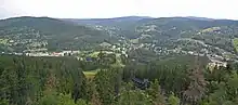
Jablonec nad Nisou District borders Poland in the northeast. The terrain is very rugged, mountainous in the north and hilly in the south. The territory extends into six geomorphological mesoregions: Jizera Mountains (north and centre), Giant Mountains (east), Giant Mountains Foothills (southeast), Zittau Basin (west), Ještěd–Kozákov Ridge (a strip in the south) and Jičín Uplands (south). The highest point of the district is the mountain Luboch in Harrachov with an elevation of 1,296 m (4,252 ft). The lowest point is the river bed of the Jizera in Malá Skála at 254 m (833 ft).
From the total district area of 438.9 km2 (169.5 sq mi), agricultural land occupies 128.7 km2 (49.7 sq mi), forests occupy 257.6 km2 (99.5 sq mi), and water area occupies 6.4 km2 (2.5 sq mi). Forests cover 58.7% of the district's area.[1]
The most important rivers are the Lusatian Neisse, Jizera and Jizera's longest tributary, the Kamenice. The area is poor in bodies of water. The largest bodies of water are the reservoirs Josefův Důl and Souš.
Most of the Giant Mountains area of the district is protected as the Krkonoše National Park and belongs to the most valuable area of the country thanks to a significant amount of rare flora and fauna. The entire north of the district belongs to the Jizerské hory Protected Landscape Area. The Bohemian Paradise Protected Landscape Area extends into the district in the south.
Demographics
|
|
| ||||||||||||||||||||||||||||||||||||||||||||||||||||||
| Source: Censuses[3][4] | ||||||||||||||||||||||||||||||||||||||||||||||||||||||||
Most populated municipalities
| Name | Population[2] | Area (km2) |
|---|---|---|
| Jablonec nad Nisou | 45,830 | 31 |
| Železný Brod | 6,079 | 23 |
| Tanvald | 6,070 | 12 |
| Smržovka | 3,851 | 15 |
| Desná | 3,103 | 13 |
| Rychnov u Jablonce nad Nisou | 2,845 | 12 |
| Velké Hamry | 2,717 | 9 |
| Pěnčín | 2,069 | 13 |
| Lučany nad Nisou | 1,953 | 13 |
| Janov nad Nisou | 1,488 | 15 |
Economy
The largest employers with headquarters in Jablonec nad Nisou District and at least 500 employees are:[5]
| Economic entity | Location | Number of employees | Main activity |
|---|---|---|---|
| Preciosa | Jablonec nad Nisou | 1,500–1,999 | Manufacture and processing of glass |
| ZF Automotive Czech | Jablonec nad Nisou | 1,500–1,999 | Automotive industry |
| Jablonec nad Nisou Hospital | Jablonec nad Nisou | 1,000–1,499 | Health care |
| TI Automotive AC | Jablonec nad Nisou | 500–999 | Automotive industry |
| Preciosa Ornela | Zásada | 500–999 | Manufacture and processing of glass |
Transport
There are no motorways in the district territory. The R/35 expressway, the continuation of the D10 motorway from Prague to Liberec, runs along the western border of the district. The most important road that pass through the district is the I/14 road from Liberec to Trutnov.
Sights

The most important monument in the district and the only one protected as a national cultural monument is the grinding plant of the glass factory in Harrachov.[6]
The best-preserved settlements, protected as monument reservations and monument zones, are:[7]
- Jizerka (monument reservation)
- Železný Brod-Trávníky (monument reservation)
- Jablonec nad Nisou
- Železný Brod
The most visited tourist destination is the Polish–Czech Friendship Trail.[8]
Notable people
References
- "Land use (as at 31 December)". Public database. Czech Statistical Office. Retrieved 2023-05-18.
- "Population of Municipalities – 1 January 2023". Czech Statistical Office. 2023-05-23.
- "Historický lexikon obcí České republiky 1869–2011 – Okres Jablonec nad Nisou" (in Czech). Czech Statistical Office. 2015-12-21. pp. 1–2.
- "Population Census 2021: Population by sex". Public Database. Czech Statistical Office. 2021-03-27.
- "Registr ekonomických subjektů". Business Register (in Czech). Czech Statistical Office. Retrieved 2023-04-04.
- "Výsledky vyhledávání: Národní kulturní památky, okres Jablonec nad Nisou". Ústřední seznam kulturních památek (in Czech). National Heritage Institute. Retrieved 2023-04-04.
- "Výsledky vyhledávání: Památkové rezervace, Památkové zóny, okres Jablonec nad Nisou". Ústřední seznam kulturních památek (in Czech). National Heritage Institute. Retrieved 2023-04-04.
- "Turisté mají v České republice nejraději zoologické zahrady, technické památky, koupání a Pražský hrad" (in Czech). CzechTourism. 2022-06-24. Retrieved 2023-04-04.
External links
- Jablonec nad Nisou District – profile on the Czech Statistical Office website