Łącznik
Łącznik [ˈwɔnt͡ʂɲik] is a village in the administrative district of Gmina Biała, within Prudnik County, Opole Voivodeship, in southern Poland.[1] It lies approximately 8 kilometres (5 mi) north-east of Biała, 18 km (11 mi) north-east of Prudnik, and 28 km (17 mi) south-west of the regional capital Opole.
Łącznik | |
|---|---|
Village | |
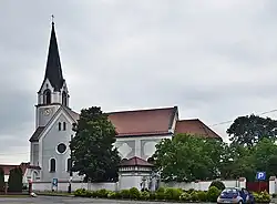
 Church of the Visitation of the Blessed Virgin Mary in Łącznik | |
 Łącznik | |
| Coordinates: 50°27′6″N 17°43′48″E | |
| Country | |
| Voivodeship | Opole |
| County | Prudnik |
| Gmina | Biała |
| Time zone | UTC+1 (CET) |
| • Summer (DST) | UTC+2 (CEST) |
| Vehicle registration | OPR |
| Voivodeship roads | |
The name of the village is of Polish origin and comes from the word łąka, which means "field".[2]
References
Wikimedia Commons has media related to Łącznik.
- "Central Statistical Office (GUS) - TERYT (National Register of Territorial Land Apportionment Journal)" (in Polish). 2008-06-01.
- Triest, Felix (1865). Topographisches Handbuch von Oberschlesien. Zweite Hälfte (in German). p. 1102.
This article is issued from Wikipedia. The text is licensed under Creative Commons - Attribution - Sharealike. Additional terms may apply for the media files.
