Ōhiwa
Ōhiwa is a rural settlement in the Ōpōtiki District and Bay of Plenty Region of New Zealand's North Island. It is on a headland on the eastern side of Ōhiwa Harbour, and on the western side of the Waiotahe River mouth.[3]
Ōhiwa | |
|---|---|
Rural settlement | |
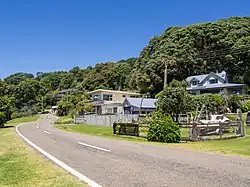 Ōhiwa Beach Road | |
| Coordinates: 37.990°S 177.161°E | |
| Country | New Zealand |
| Region | Bay of Plenty |
| Territorial authority | Ōpōtiki District |
| Ward | Waioeka-Waiōtahe-Otara Ward |
| Electorates | |
| Government | |
| • Territorial authority | Ōpōtiki District Council |
| • Regional council | Bay of Plenty Regional Council |
| Area | |
| • Total | 3.96 km2 (1.53 sq mi) |
| Population (June 2023)[2] | |
| • Total | 190 |
| • Density | 48/km2 (120/sq mi) |
| Postcode(s) | 3174 |
The New Zealand Geographic Board officially included the macron in the name from 16 July 2020.[4]
The Ferry Hotel was opened at Ōhiwa in 1873, together with a ferry service to Ōhope. A post office opened in the growing town in 1877. Unstable sand and erosion from 1915 destroyed the town. A second attempt to create sections for baches in the 1960s was also lost to erosion in 1978.[5]
Onekawa Te Mawhai Regional Park was created on the headland in 2010. It incorporates areas of archaeological importance from long Māori use of the area, including Onekawa pā.[6]
A local campground provides accommodation.[7]
Demographics
Ōhiwa is described by Statistics New Zealand as a rural settlement, which covers 3.96 km2 (1.53 sq mi)[1] and had an estimated population of 190 as of June 2023,[2] with a population density of 48 people per km2. It is part of the wider Waiotahi statistical area.[8]
| Year | Pop. | ±% p.a. |
|---|---|---|
| 2006 | 177 | — |
| 2013 | 156 | −1.79% |
| 2018 | 171 | +1.85% |
| Source: [9] | ||
Ōhiwa had a population of 171 at the 2018 New Zealand census, an increase of 15 people (9.6%) since the 2013 census, and a decrease of 6 people (−3.4%) since the 2006 census. There were 69 households, comprising 84 males and 93 females, giving a sex ratio of 0.9 males per female. The median age was 55.6 years (compared with 37.4 years nationally), with 27 people (15.8%) aged under 15 years, 15 (8.8%) aged 15 to 29, 87 (50.9%) aged 30 to 64, and 48 (28.1%) aged 65 or older.
Ethnicities were 89.5% European/Pākehā, 24.6% Māori, and 1.8% Asian. People may identify with more than one ethnicity.
Although some people chose not to answer the census's question about religious affiliation, 61.4% had no religion, 28.1% were Christian, 7.0% had Māori religious beliefs, 1.8% were Hindu and 3.5% had other religions.
Of those at least 15 years old, 42 (29.2%) people had a bachelor's or higher degree, and 15 (10.4%) people had no formal qualifications. The median income was $32,900, compared with $31,800 nationally. 27 people (18.8%) earned over $70,000 compared to 17.2% nationally. The employment status of those at least 15 was that 69 (47.9%) people were employed full-time, 18 (12.5%) were part-time, and 6 (4.2%) were unemployed.[9]
References
- "ArcGIS Web Application". statsnz.maps.arcgis.com. Retrieved 12 January 2023.
- "Subnational population estimates (RC, SA2), by age and sex, at 30 June 1996-2023 (2023 boundaries)". Statistics New Zealand. Retrieved 25 October 2023. (regional councils); "Subnational population estimates (TA, SA2), by age and sex, at 30 June 1996-2023 (2023 boundaries)". Statistics New Zealand. Retrieved 25 October 2023. (territorial authorities); "Subnational population estimates (urban rural), by age and sex, at 30 June 1996-2023 (2023 boundaries)". Statistics New Zealand. Retrieved 25 October 2023. (urban areas)
- Harriss, Gavin (August 2022). Ohiwa, Bay of Plenty (Map). NZ Topo Map.
- "Notice of Approved Official Geographic Names". New Zealand Gazette. 16 July 2020.
- Quinn, Peter James (May 2002). "Ohiwa – The food basket of many hands". New Zealand Geographic Magazine.
- "Onekawa Te Mawhai Regional Park". Bay of Plenty Region. Retrieved 12 January 2023.
- "Ohiwa Beach". Tasman Holiday Parks. Retrieved 12 January 2023.
- 2018 Census place summary: Waiotahi
- "Statistical area 1 dataset for 2018 Census". Statistics New Zealand. March 2020. 7015415.