Ōrewa River
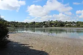
The Ōrewa River is a river of the Auckland Region of New Zealand's North Island. It flows east to reach Whangaparāoa Bay just to the north of Whangaparaoa Peninsula. The town of Orewa is near the river's mouth.
| Ōrewa River | |
|---|---|
 | |
Route of the Ōrewa River | |
 Mouth of the Ōrewa River  Ōrewa River (New Zealand) | |
| Location | |
| Country | New Zealand |
| Region | Auckland Region |
| Physical characteristics | |
| Source | |
| • location | Wainui |
| • coordinates | 36.6027°S 174.6106°E |
| Mouth | Whangaparāoa Bay |
• coordinates | 36.5984°S 174.7018°E |
| Length | 10 km (6 mi) |
| Basin features | |
| Progression | Ōrewa River → Whangaparāoa Bay → Hauraki Gulf |
| Tributaries | |
| • right | Waterloo Creek |
Geography
The Ōrewa River begins as a freshwater river flowing east through the Hibiscus Coast area. As it reaches the Hauraki Gulf, the river forms a shallow estuary.[1][2] The river has one major tributary, the Waterloo Creek,[3] and has an island in the river estuary, Te Motu-o-Marae-Ariki, also known as Crocodile Island.[4]
History
The Aotoetoe Portage allowed waka to cross between the Kaipara Harbour in the west to the Hauraki Gulf, via the Kaukapakapa River. A similar portage linked between the Kaukapakapa River and the Weiti River to the south.[5]
Amenities
Te Ara Tahuna Estuary Walk is a circular walk around the Ōrewa River estuary.[1]
See also
References
- Janssen, Peter (January 2021). Greater Auckland Walks. New Holland Publishers. p. 32-33. ISBN 978-1-86966-516-6. Wikidata Q118136068.
- "Ōrewa River". LINZ. Retrieved 4 May 2023.
- "Waterloo Creek". LINZ. Retrieved 4 May 2023.
- "Te Motu-o-Marae-Ariki". LINZ. Retrieved 4 May 2023.
- Hooker, Brian (September 1997). "Portages of early Auckland - to and from the Waitemata Harbour: The hub of an ancient communications network". Auckland-Waikato Historical Journal (70): 39–40. Retrieved 21 July 2022.