Ōtara Creek
The Ōtara Creek, is a major stream in South Auckland, in the Auckland Region of New Zealand's North Island. It flows northwards, then westwards into the Tāmaki River.
| Ōtara Creek | |
|---|---|
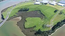
 The mouth of the creek as it enters the Tāmaki River | |
Route of the Ōtara Creek | |
 Mouth of the Ōtara Creek  Ōtara Creek (New Zealand) | |
| Location | |
| Country | New Zealand |
| Region | Auckland Region |
| Physical characteristics | |
| Source | Papatoetoe |
| • coordinates | 36.97782°S 174.87351°E |
| Mouth | Tāmaki River |
• coordinates | 36.94539°S 174.86224°E |
| Basin features | |
| Progression | Ōtara Creek → Tāmaki River → Tāmaki Strait → Hauraki Gulf |
| Bridges | Ōtara Creek Bridge, Ōtara Creek Pedestrian Bridge |
Etymology


The name of the creek comes from its name in Māori, Te Waiōtara. The name literally means "The Waters of Tara", referencing Te Irirangi, a Ngāi Tai ki Tāmaki rangatira of the early 19th Century, who was also known by the name Te Tara.[1][2] During the 19th and early 20th centuries, European farmers referred to the creek as Goodfellow's Creek.[3]
Description
The creek begins in Papatoetoe, near Allenby Park and Papatoetoe High School. It flows north through the suburbs of Papatoetoe and Ōtara, becoming a tidal estuary that separates Ōtara from East Tāmaki in the north.[4] The tidal creek flows into Pukewairiki, a volcanic maar that erupted an estimated 130,000 years ago.[5][6][4]
The creek's catchment covers an area of 3,477 hectares (8,590 acres).[7]
History
The creek is in the traditional rohe of Ngāi Tai ki Tāmaki. The stream was used as a source for freshwater resources, including koura and eels, and the banks of the stream were the location of many kāinga.[1][2]
In 2007, a 210 metres (690 ft) bridge was constructed at the mouth of the creek along Highbrook Drive, as a new motorway exchange to connect East Tāmaki to the Auckland Southern Motorway.[8]
In June 2016, the Ōtara Waterways & Lake Trust was formed, as a community organisation that focused on the clean-up and revitalisation of the creek.[9][10]
Amenities
The Ōtara Path is a major walking path on the western/southern banks of the creek.[11] Ngāti Ōtara Park is a large park found on the southern banks of the creek.[12] In 2020, a new public bridge was constructed at Ōtara Creek Reserve, crossing the creek.[13]
See also
References
- Ngāti Te Ata Waiohua (December 2012). Redoubt Road – Mill Road Corridor Project Maori Values Assessment for Auckland Transport (PDF) (Report). Auckland Transport. Retrieved 30 March 2023.
- Green, Nat (2010). Ōtau: a Ngāi Tai Cultural Heritage Assessment of Clevedon Village, Wairoa Valley (PDF) (Report). Auckland Council. Retrieved 21 October 2022.
- Clark, Jennifer A. (2002). East Tamaki: Including the Adjoining Areas of Flat Bush and Otara. Papatoetoe Historical Society. p. 28. ISBN 0-473-09058-9. OCLC 156099387. Wikidata Q120020174.
- "Ōtara Creek". New Zealand Gazetteer. Land Information New Zealand. Retrieved 5 May 2023.
- Hopkins, Jenni L.; Smid, Elaine R.; Eccles, Jennifer D.; Hayes, Josh L.; Hayward, Bruce W.; McGee, Lucy E.; van Wijk, Kasper; Wilson, Thomas M.; Cronin, Shane J.; Leonard, Graham S.; Lindsay, Jan M.; Németh, Karoly; Smith, Ian E. M. (3 July 2021). "Auckland Volcanic Field magmatism, volcanism, and hazard: a review". New Zealand Journal of Geology and Geophysics. 64 (2–3): 213–234. doi:10.1080/00288306.2020.1736102. S2CID 216443777.
- Volcanoes of Auckland: A Field Guide. Hayward, B.W.; Auckland University Press, 2019, 335 pp. ISBN 0-582-71784-1.
- "About the catchment". Ōtara Waterways & Lake Trust. Retrieved 5 May 2023.
- "New Motorway Interchange Opens Up Opportunities". Scoop. 17 April 2007. Retrieved 5 May 2023.
- "About Us". Ōtara Waterways & Lake Trust. Retrieved 5 May 2023.
- Harrowell, Chris (11 September 2017). "Trust aims to reverse two decades of waterway neglect and pollution". Stuff. Retrieved 5 May 2023.
- "Ōtara Path". Auckland Council. Retrieved 5 May 2023.
- "Ngati Otara Park". Auckland Council. Retrieved 5 May 2023.
- OurAuckland (14 February 2020). "New pedestrian bridge brings public art to Ōtara Creek Reserve". Auckland Council. Retrieved 5 May 2023.