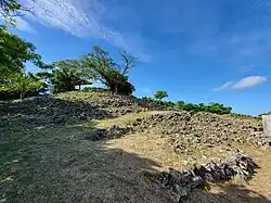
Ōzato Castle
Ōzato Castle (大里城, Ōzato jō, Okinawan: Ufuzatu Gushiku), officially Shimasoe-Ōzato Castle (島添大里城, Shimasoe-Ōzato jō, Okinawan: Shimashii-Ufuzatu Gushiku), is a Ryukyuan gusuku built in Nanzan and used until 1429. It, and the village of Ōzato, are named after the Ōzato Dynasty of Nanzan. It is in ruins, and is an officially designated historical site in Nanjō City, Okinawa.[1]
| Ōzato Castle 島添大里城 | |
|---|---|
| Nanjō, Okinawa | |
 Ruins in February 2023 | |
 Ōzato Castle 島添大里城  Ōzato Castle 島添大里城 | |
| Type | Gusuku |
| Site information | |
| Controlled by | Nanzan (1314–1429) Chūzan (1429) |
| Open to the public | yes |
| Condition | Ruins |
| Site history | |
| Built | early 14th century |
| Built by | Ōzato Magiri Aji |
| In use | early 14th century – 1429 |
| Materials | Ryukyuan limestone, wood |
| Garrison information | |
| Occupants | Aji of Ōzato Magiri |
History
Nanzan was established in 1314 when the Lord of Shimajiri-Ōzato, Ōzato Ofusato, broke away from the chieftain Tamagusuku at Urasoe Castle. The castle was built in the 14th century West of the farming village of Ōzato, and became the seat of the Aji of Ōzato Magiri.[2] It fell into disuse after the capture of Nanzan Castle in 1429. During an excavation of the site, Chinese ceramics were found, showing the extensive trade that Nanzan had done with Ming China.[3] In 2012, Ōzato castle became an officially designated historical site on Okinawa Island.[1]
References
- Tokumori, Lima, and Mark Ealey. "Cultural Affairs Council Recommends Two Okinawan Sites to Minister of MEXT." Ryukyu Shimpo [Naha] 19 November 2011: n. pag. Ryukyu Shimpo. Web. 13 January 2014.
- "南城なび|Nanjo Navigator~南城市 観光・文化情報サイト". nanjo-navi.jp. Retrieved 13 August 2018.
- 島添大里城跡 [Shimashīōzato Castle Site] (in Japanese). Agency for Cultural Affairs. Retrieved 25 March 2014.
External links
- http://english.ryukyushimpo.jp/2011/11/29/3883/
- http://okininjakitty.wordpress.com/2013/02/28/ozato-castle-ruins/