145th Street station (IND lines)
The 145th Street station is a bi-level express station on the IND Eighth Avenue and Concourse lines of the New York City Subway, located at the intersection of 145th Street and St. Nicholas Avenue in Harlem and Hamilton Heights, Manhattan. It is served by the A and D trains at all times, by the C train at all times except late nights, and by the B train on weekdays only.
145 Street | |||||||||||||||||||||||||||||||||||||||||||||||||||||||||||||||||||||||||||||||||||||||||||||||||||||||||||||||||||||||||||||||||||||||||||||||||||||||||||||||||||||||||||||||||||||||||||||||||||||||||||||||||||||||||||||||||||||||||
|---|---|---|---|---|---|---|---|---|---|---|---|---|---|---|---|---|---|---|---|---|---|---|---|---|---|---|---|---|---|---|---|---|---|---|---|---|---|---|---|---|---|---|---|---|---|---|---|---|---|---|---|---|---|---|---|---|---|---|---|---|---|---|---|---|---|---|---|---|---|---|---|---|---|---|---|---|---|---|---|---|---|---|---|---|---|---|---|---|---|---|---|---|---|---|---|---|---|---|---|---|---|---|---|---|---|---|---|---|---|---|---|---|---|---|---|---|---|---|---|---|---|---|---|---|---|---|---|---|---|---|---|---|---|---|---|---|---|---|---|---|---|---|---|---|---|---|---|---|---|---|---|---|---|---|---|---|---|---|---|---|---|---|---|---|---|---|---|---|---|---|---|---|---|---|---|---|---|---|---|---|---|---|---|---|---|---|---|---|---|---|---|---|---|---|---|---|---|---|---|---|---|---|---|---|---|---|---|---|---|---|---|---|---|---|---|---|---|---|---|---|---|---|---|---|---|---|---|---|---|---|---|---|---|
 Uptown local platform with a C train | |||||||||||||||||||||||||||||||||||||||||||||||||||||||||||||||||||||||||||||||||||||||||||||||||||||||||||||||||||||||||||||||||||||||||||||||||||||||||||||||||||||||||||||||||||||||||||||||||||||||||||||||||||||||||||||||||||||||||
| Station statistics | |||||||||||||||||||||||||||||||||||||||||||||||||||||||||||||||||||||||||||||||||||||||||||||||||||||||||||||||||||||||||||||||||||||||||||||||||||||||||||||||||||||||||||||||||||||||||||||||||||||||||||||||||||||||||||||||||||||||||
| Address | West 145th Street & St. Nicholas Avenue New York, NY 10031 | ||||||||||||||||||||||||||||||||||||||||||||||||||||||||||||||||||||||||||||||||||||||||||||||||||||||||||||||||||||||||||||||||||||||||||||||||||||||||||||||||||||||||||||||||||||||||||||||||||||||||||||||||||||||||||||||||||||||||
| Borough | Manhattan | ||||||||||||||||||||||||||||||||||||||||||||||||||||||||||||||||||||||||||||||||||||||||||||||||||||||||||||||||||||||||||||||||||||||||||||||||||||||||||||||||||||||||||||||||||||||||||||||||||||||||||||||||||||||||||||||||||||||||
| Locale | Harlem, Hamilton Heights | ||||||||||||||||||||||||||||||||||||||||||||||||||||||||||||||||||||||||||||||||||||||||||||||||||||||||||||||||||||||||||||||||||||||||||||||||||||||||||||||||||||||||||||||||||||||||||||||||||||||||||||||||||||||||||||||||||||||||
| Coordinates | 40.82404°N 73.944769°W | ||||||||||||||||||||||||||||||||||||||||||||||||||||||||||||||||||||||||||||||||||||||||||||||||||||||||||||||||||||||||||||||||||||||||||||||||||||||||||||||||||||||||||||||||||||||||||||||||||||||||||||||||||||||||||||||||||||||||
| Division | B (IND)[1] | ||||||||||||||||||||||||||||||||||||||||||||||||||||||||||||||||||||||||||||||||||||||||||||||||||||||||||||||||||||||||||||||||||||||||||||||||||||||||||||||||||||||||||||||||||||||||||||||||||||||||||||||||||||||||||||||||||||||||
| Line | IND Eighth Avenue Line IND Concourse Line | ||||||||||||||||||||||||||||||||||||||||||||||||||||||||||||||||||||||||||||||||||||||||||||||||||||||||||||||||||||||||||||||||||||||||||||||||||||||||||||||||||||||||||||||||||||||||||||||||||||||||||||||||||||||||||||||||||||||||
| Services | A B C D | ||||||||||||||||||||||||||||||||||||||||||||||||||||||||||||||||||||||||||||||||||||||||||||||||||||||||||||||||||||||||||||||||||||||||||||||||||||||||||||||||||||||||||||||||||||||||||||||||||||||||||||||||||||||||||||||||||||||||
| Transit | |||||||||||||||||||||||||||||||||||||||||||||||||||||||||||||||||||||||||||||||||||||||||||||||||||||||||||||||||||||||||||||||||||||||||||||||||||||||||||||||||||||||||||||||||||||||||||||||||||||||||||||||||||||||||||||||||||||||||
| Structure | Underground | ||||||||||||||||||||||||||||||||||||||||||||||||||||||||||||||||||||||||||||||||||||||||||||||||||||||||||||||||||||||||||||||||||||||||||||||||||||||||||||||||||||||||||||||||||||||||||||||||||||||||||||||||||||||||||||||||||||||||
| Levels | 2 | ||||||||||||||||||||||||||||||||||||||||||||||||||||||||||||||||||||||||||||||||||||||||||||||||||||||||||||||||||||||||||||||||||||||||||||||||||||||||||||||||||||||||||||||||||||||||||||||||||||||||||||||||||||||||||||||||||||||||
| Platforms | 4 island platforms (2 on each level) cross-platform interchange | ||||||||||||||||||||||||||||||||||||||||||||||||||||||||||||||||||||||||||||||||||||||||||||||||||||||||||||||||||||||||||||||||||||||||||||||||||||||||||||||||||||||||||||||||||||||||||||||||||||||||||||||||||||||||||||||||||||||||
| Tracks | 7 (4 on upper level, 3 on lower level) | ||||||||||||||||||||||||||||||||||||||||||||||||||||||||||||||||||||||||||||||||||||||||||||||||||||||||||||||||||||||||||||||||||||||||||||||||||||||||||||||||||||||||||||||||||||||||||||||||||||||||||||||||||||||||||||||||||||||||
| Other information | |||||||||||||||||||||||||||||||||||||||||||||||||||||||||||||||||||||||||||||||||||||||||||||||||||||||||||||||||||||||||||||||||||||||||||||||||||||||||||||||||||||||||||||||||||||||||||||||||||||||||||||||||||||||||||||||||||||||||
| Opened | September 10, 1932[2] | ||||||||||||||||||||||||||||||||||||||||||||||||||||||||||||||||||||||||||||||||||||||||||||||||||||||||||||||||||||||||||||||||||||||||||||||||||||||||||||||||||||||||||||||||||||||||||||||||||||||||||||||||||||||||||||||||||||||||
| Accessibility | Cross-platform wheelchair transfer available | ||||||||||||||||||||||||||||||||||||||||||||||||||||||||||||||||||||||||||||||||||||||||||||||||||||||||||||||||||||||||||||||||||||||||||||||||||||||||||||||||||||||||||||||||||||||||||||||||||||||||||||||||||||||||||||||||||||||||
| Opposite- direction transfer | Yes | ||||||||||||||||||||||||||||||||||||||||||||||||||||||||||||||||||||||||||||||||||||||||||||||||||||||||||||||||||||||||||||||||||||||||||||||||||||||||||||||||||||||||||||||||||||||||||||||||||||||||||||||||||||||||||||||||||||||||
| Traffic | |||||||||||||||||||||||||||||||||||||||||||||||||||||||||||||||||||||||||||||||||||||||||||||||||||||||||||||||||||||||||||||||||||||||||||||||||||||||||||||||||||||||||||||||||||||||||||||||||||||||||||||||||||||||||||||||||||||||||
| 2019 | 7,464,653[3] | ||||||||||||||||||||||||||||||||||||||||||||||||||||||||||||||||||||||||||||||||||||||||||||||||||||||||||||||||||||||||||||||||||||||||||||||||||||||||||||||||||||||||||||||||||||||||||||||||||||||||||||||||||||||||||||||||||||||||
| Rank | 49 out of 424[3] | ||||||||||||||||||||||||||||||||||||||||||||||||||||||||||||||||||||||||||||||||||||||||||||||||||||||||||||||||||||||||||||||||||||||||||||||||||||||||||||||||||||||||||||||||||||||||||||||||||||||||||||||||||||||||||||||||||||||||
| |||||||||||||||||||||||||||||||||||||||||||||||||||||||||||||||||||||||||||||||||||||||||||||||||||||||||||||||||||||||||||||||||||||||||||||||||||||||||||||||||||||||||||||||||||||||||||||||||||||||||||||||||||||||||||||||||||||||||
| |||||||||||||||||||||||||||||||||||||||||||||||||||||||||||||||||||||||||||||||||||||||||||||||||||||||||||||||||||||||||||||||||||||||||||||||||||||||||||||||||||||||||||||||||||||||||||||||||||||||||||||||||||||||||||||||||||||||||
| |||||||||||||||||||||||||||||||||||||||||||||||||||||||||||||||||||||||||||||||||||||||||||||||||||||||||||||||||||||||||||||||||||||||||||||||||||||||||||||||||||||||||||||||||||||||||||||||||||||||||||||||||||||||||||||||||||||||||
| |||||||||||||||||||||||||||||||||||||||||||||||||||||||||||||||||||||||||||||||||||||||||||||||||||||||||||||||||||||||||||||||||||||||||||||||||||||||||||||||||||||||||||||||||||||||||||||||||||||||||||||||||||||||||||||||||||||||||
| |||||||||||||||||||||||||||||||||||||||||||||||||||||||||||||||||||||||||||||||||||||||||||||||||||||||||||||||||||||||||||||||||||||||||||||||||||||||||||||||||||||||||||||||||||||||||||||||||||||||||||||||||||||||||||||||||||||||||
History
Planning and opening
On August 3, 1923, the New York City Board of Estimate approved the Washington Heights Line, an extension of the Broadway Line to Washington Heights. The line was to have four tracks from Central Park West at 64th Street under Central Park West, Eighth Avenue, Saint Nicholas Avenue, and private property to 173rd Street, and two tracks under Fort Washington Avenue to 193rd Street. South of 64th Street, one two-track line would connect to the Broadway Line stubs at 57th Street, and another would continue under Eighth Avenue to 30th Street at Penn Station, with provisions to continue downtown.[4][5]
Mayor John Hylan instead wanted to build an independent subway system, operated by the city. The New York City Board of Transportation (NYCBOT) gave preliminary approval to several lines in Manhattan, including one on Eighth Avenue, on December 9, 1924. The main portion of the already-approved Washington Heights Line—the mostly-four track line north of 64th Street—was included, but was to continue north from 193rd Street to 207th Street. South of 64th Street, the plan called for four tracks in Eighth Avenue, Greenwich Avenue, the planned extension of Sixth Avenue, and Church Street. Two tracks would turn east under Fulton Street or Wall Street and under the East River to Downtown Brooklyn.[6][7]
A groundbreaking ceremony was held at St. Nicholas Avenue and 123rd Street on March 14, 1925.[8] Most of the Eighth Avenue Line was dug using a cheap cut-and-cover method, where the street above was excavated. Still, the construction of the line was difficult, as it had to go under or over several subway lines.[9]
The station opened on September 10, 1932, as part of the city-operated Independent Subway System (IND)'s initial segment, the Eighth Avenue Line between Chambers Street and 207th Street.[2][10] At this time, only the upper level of the station opened, as the IND Concourse Line was still under construction. When the IND Concourse Line opened for service on July 1, 1933,[11] the lower level was opened.[12]
Later years
The station has been undergoing renovations since 2017 as part of the 2010–2014 MTA Capital Program. This is because of an MTA study conducted in 2015, which found that 45 percent of components were out of date.[13]
Station layout
| G | Street level | Entrance/exit |
| B1 | Mezzanine | Fare control, station agents, MetroCard machines |
| B2 Eighth Avenue Line platforms |
Northbound local | ← ← |
| Island platform | ||
| Northbound express | ← | |
| Southbound express | Rockaway Park–Beach 116th Street (125th Street) → | |
| Island platform | ||
| Southbound local | | |
| B3 Concourse Line platforms |
Northbound local | ← ← |
| Island platform | ||
| Peak-direction express/ short turn |
← | |
| Island platform | ||
| Southbound local | | |


The upper level has four tracks and two island platforms. The station used to have a full mezzanine, now, the central portion is used as a police precinct. The lower level has three tracks and two island platforms. The northbound platform here is twice as wide as the station's other three similarly sized platforms, being 39 feet wide, so that the three trackways on the lower level line up directly with those above.[12][14] Escalators lead up from this level to the mezzanine, bypassing the upper-level platforms.
The center track on the lower level is used to terminate B trains during middays and early evenings, when it does not run into the Bronx. During rush hours, this track is used by D trains that run express on the IND Concourse Line in the peak direction. This track is not used during late nights or weekends.[14][15][16][17]
On the upper level, just north of the station, there is an open space next to the uptown local track [18] that was a remnant of the construction of the subway and not built for a specific purpose. That open space is where the lower level tracks turn off to the IND Concourse Line. There is a hole in the floor that allows a view of the lower level.
Both levels have a trim line on the track walls, which is yellow with a black border. It is two tiles high, a pattern usually reserved for local stations. Tile captions reading "145" in white lettering on black run below the trim line at regular intervals. The trim line was part of a color-coded tile system used throughout the IND.[19] The tile colors were designed to facilitate navigation for travelers going away from Lower Manhattan. As such, a different tile color is used at 168th Street and Tremont Avenue, the next express stations to the north on the Eighth Avenue and Concourse lines, respectively. Yellow tiles are used at the local stations between 145th Street and either 168th Street or Tremont Avenue.[20][21] Yellow I-beam columns run along all the platforms, alternating ones having the standard black station name plate with white lettering.
South of this station, through 135th Street, to just north of 125th Street, the line has six tracks. The express trains use the innermost pair of tracks, and the locals uses the outermost tracks. This section of the line is nicknamed “Homeball Alley” due to the large amount of switches and signals in this area.[14][22]
Exits
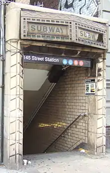
The full-time entrance is at 145th Street with a part-time north exit at 147th Street. The station has entrances leading to each corner of St. Nicholas Avenue and West 145th Street, an entrance between buildings on the west side of St. Nicholas Avenue between West 147th and West 148th Streets, and an entrance on the east side of St. Nicholas Avenue between West 147th and West 148th Streets.[23] There is a closed exit to the northwestern corner of St. Nicholas Avenue and West 146th Street.[13]
References
- "Glossary". Second Avenue Subway Supplemental Draft Environmental Impact Statement (SDEIS) (PDF). Vol. 1. Metropolitan Transportation Authority. March 4, 2003. pp. 1–2. Archived from the original (PDF) on February 26, 2021. Retrieved January 1, 2021.
- "List of the 28 Stations on the New 8th Av. Line". The New York Times. September 10, 1932. p. 6. ISSN 0362-4331. Retrieved 2020-04-21.
- "Facts and Figures: Annual Subway Ridership 2014–2019". Metropolitan Transportation Authority. 2020. Retrieved May 26, 2020.
- "Two Subway Routes Adopted by City". The New York Times. August 4, 1923. p. 9. ISSN 0362-4331. Retrieved June 29, 2018.
- "Plans Now Ready to Start Subways". The New York Times. March 12, 1924. p. 1. ISSN 0362-4331. Retrieved June 29, 2018.
- "Hylan Subway Plan Links Four Boroughs at $450,000,000 Cost". The New York Times. December 10, 1924. p. 1. ISSN 0362-4331. Retrieved June 29, 2018.
- Raskin, Joseph B. (2013). The Routes Not Taken: A Trip Through New York City's Unbuilt Subway System. New York, New York: Fordham University Press. doi:10.5422/fordham/9780823253692.001.0001. ISBN 978-0-82325-369-2.
- "Will Break Ground Today for New Uptown Subway". The New York Times. March 14, 1925. p. 15. ISSN 0362-4331. Retrieved June 29, 2018.
- Warner, Arthur (November 22, 1931). "The City's New Underground Province; The Eighth Avenue Subway Will Be Not Only a Transit Line but a Centre for the Shopper A New Underground Province of New York The Eighth Avenue Subway Will Be a Rapid Transit Line With Innovations and Will Provide Centres for the Shoppers". The New York Times. ISSN 0362-4331. Retrieved May 2, 2018.
- Crowell, Paul (September 10, 1932). "Gay Midnight Crowd Rides First Trains In The New Subway: Throngs at Station an Hour Before Time, Rush Turnstiles When Chains are Dropped" (PDF). The New York Times. Retrieved November 8, 2015.
- "New Bronx Subway Starts Operation" (PDF). The New York Times. July 1, 1933. p. 15.
- Kramer, Frederick A. (January 1, 1990). Building the Independent Subway. Quadrant Press. ISBN 9780915276509.
- Review of the A and C Lines (PDF) (Report). Metropolitan Transportation Authority. December 11, 2015. Archived from the original (PDF) on February 3, 2020. Retrieved January 19, 2016.
- Dougherty, Peter (2006) [2002]. Tracks of the New York City Subway 2006 (3rd ed.). Dougherty. OCLC 49777633 – via Google Books.
- "B Train Subway Timetable June 12, 2016" (PDF). mta.info. Metropolitan Transportation Authority. June 12, 2016. Retrieved July 17, 2016.
- "D Train Subway Timetable June 12, 2016" (PDF). mta.info. Metropolitan Transportation Authority. June 12, 2016. Retrieved July 17, 2016.
- "Harlem - 145 Street (A,B,C,D)". www.subwaynut.com. Archived from the original on September 30, 2019. Retrieved July 17, 2016.
- https://www.youtube.com/watch?v=MiTJoNPqjH4&t=3m31s The “bellmouth” or that open space is visible to the right at the 3:33 mark, just as the train leaves the 145th Street station (Upper level).
- "Tile Colors a Guide in the New Subway; Decoration Scheme Changes at Each Express Stop to Tell Riders Where They Are". The New York Times. August 22, 1932. ISSN 0362-4331. Archived from the original on July 1, 2022. Retrieved July 1, 2022.
- Carlson, Jen (February 18, 2016). "Map: These Color Tiles In The Subway System Used To Mean Something". Gothamist. Retrieved May 10, 2023.
- Gleason, Will (February 18, 2016). "The hidden meaning behind the New York subway's colored tiles". Time Out New York. Retrieved May 10, 2023.
- Matus, Paul (March 17, 2000). "rapidtransit.net - Tracks of the NYC Subway by Peter Dougherty Reviewed, Page 2". www.rapidtransit.net. Archived from the original on April 25, 2020. Retrieved April 25, 2020.
- "MTA Neighborhood Maps: Harlem / Hamilton Heights" (PDF). Metropolitan Transportation Authority. 2018. Retrieved October 1, 2018.
External links
- nycsubway.org – IND 8th Avenue: 145th Street
- Station Reporter — A Lefferts
- Station Reporter — A Rockaway
- Station Reporter — B Train
- Station Reporter — C Train
- Station Reporter — D Train
- The Subway Nut — 145th Street Pictures Archived 2019-09-30 at the Wayback Machine
- 145th Street modern entrance from Google Maps Street View
- 147th Street entrance from Google Maps Street View
- Upper platforms from Google Maps Street View
- Lower platforms from Google Maps Street View


