2008 Atlanta tornado outbreak
The 2008 Atlanta tornado outbreak was a destructive and deadly tornado outbreak that affected the Southeastern United States on March 14–15, 2008. The most infamous tornado of the outbreak occurred on March 14 when an isolated but strong EF2 tornado caused widespread damage across Downtown Atlanta, Georgia, including to the CNN Center and to the Georgia Dome, which was hosting the 2008 SEC men's basketball tournament. Other buildings that were damaged include the Georgia World Congress Center, Phillips Arena (now State Farm Arena) during an Atlanta Hawks game, and the Omni Hotel, which was evacuated after many windows were blown out. The Westin Peachtree Plaza Hotel suffered major window damage. The image of the building with all its windows blown out became famous and for a time was a symbol of the tornado. Centennial Olympic Park, SunTrust Plaza (now Truist Plaza) and historic Oakland Cemetery were also damaged.[1]
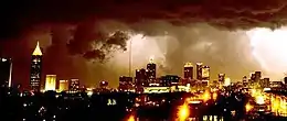 Tornado (shadow at left), after going through downtown Atlanta | |
| Type | Tornado outbreak |
|---|---|
| Duration | March 14–15, 2008 |
| Tornadoes confirmed | 46 confirmed |
| Max. rating1 | EF3 tornado |
| Duration of tornado outbreak2 | 24 hours, 7 minutes |
| Fatalities | 3 fatalities (1 in Atlanta), 53 injuries |
| Damage | >$250 million |
| Areas affected | Alabama, Georgia, North Carolina, South Carolina |
Part of tornado outbreaks of 2008 1Most severe tornado damage; see Enhanced Fujita scale 2Time from first tornado to last tornado | |
One man was killed near Downtown Atlanta and 30 others were injured.[2] Two other deaths took place on March 15, in the northern Atlanta suburbs, from a second, larger round of severe weather and tornadoes. In total, 46 tornadoes were confirmed over the 24-hour period, from eastern Alabama to the Carolina coast, with most of the activity concentrated in the Metropolitan Atlanta area, the Central Savannah River Area and the Midlands of South Carolina.
Meteorological synopsis
Atlanta tornado event
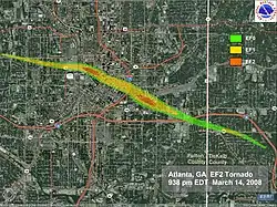
In their 9:00 pm EDT outlook, the Storm Prediction Center issued a slight risk of severe weather across portions of the southern United States from Oklahoma to Georgia, with a 2% risk area for tornadoes for the Atlanta area.[3] A tornado warning was issued for Atlanta at 9:26 pm when the thunderstorm that caused the tornado was 6 miles (10 km) northwest of the downtown area, although no watches were in effect for the area due to the low probability and unusual isolated nature. The tornado moved to the southeast, which is unusual as most supercells have a strong northward component along (or ahead of) a cold front. It also was unusual because it was not associated with such a squall line at all, but was an independent supercell well ahead of the main storm system.
March 15 tornado event
Another tornado outbreak struck the southeast the following day. A moderate risk for severe storms was issued early in the morning, and maintained through the afternoon.[4] However, by mid afternoon, areas of east-central Georgia and central South Carolina were upgraded to a high risk of severe storms due to the tornado threat.[5][6]
Confirmed tornadoes
| EFU | EF0 | EF1 | EF2 | EF3 | EF4 | EF5 | Total |
|---|---|---|---|---|---|---|---|
| 0 | 11 | 16 | 16 | 3 | 0 | 0 | 46 |
March 14 event
| EF# | Location | County / Parish | State | Start Coord. | Time (UTC) | Path length | Max width | Damage[note 2] | Summary |
|---|---|---|---|---|---|---|---|---|---|
| EF2 | N of Warren | Cleveland | AR | 33.7201°N 92.1632°W | 0842–0855 | 9.4 mi (15.1 km) | 350 yd (320 m) | $1,000,000 | An old, unoccupied house was destroyed. Several houses sustained roof and shingle damage, including two that had most of their roofs blown off. Several chicken houses were destroyed, and a number of barns and outbuildings were damaged. Hundreds of trees were downed; one destroyed a house trailer.[7] |
| EF2 | Atlanta | Fulton, DeKalb | GA | 33.765°N 84.43°W | 0138–0150 | 6.25 mi (10.06 km) | 200 yd (180 m) | $25,050,000 | 1 death – See section on this tornado – 30 people were injured.[8][9] |
March 15 event
| EF# | Location | County / Parish | State | Start Coord. | Time (UTC) | Path length | Max width | Damage[note 2] | Summary |
|---|---|---|---|---|---|---|---|---|---|
| EF2 | SE of Oneonta | Blount | AL | 33.8716°N 86.4459°W | 1447–1457 | 6.04 mi (9.72 km) | 675 yd (617 m) | $960,000 | The Appalachian School property sustained damage, several hundred trees were snapped or uprooted, and many chicken houses were damaged or destroyed. Many garages, sheds, and outbuildings were destroyed. At least 25 homes sustained major damage while dozens more sustained lesser damage. A mobile home was destroyed and several others were damaged, a few feed silos were tipped over and rolled, and hundreds of livestock were killed by flying debris.[10] |
| EF2 | N of Piedmont | Cherokee | AL | 33.9835°N 85.6295°W | 1550–1554 | 3.61 mi (5.81 km) | 50 yd (46 m) | $75,000 | Metal roofing panels were torn from a barn, and half the roof was torn from a brick house. Two other homes and a barn also sustained structural damage. Numerous trees were snapped or uprooted.[11] |
| EF3 | NW of Aragon to W of Emerson | Polk, Floyd, Bartow | GA | 34.09°N 85.11°W | 1625–1645 | 16.93 mi (27.25 km) | 880 yd (800 m) | $7,500,000 | 2 deaths – A significant tornado began in Polk County, affecting 16 houses; 4 were destroyed (killing an occupant), 2 sustained major damage, 5 sustained minor damage, and 5 sustained even lesser damage. Several county outbuildings, barns, shops, vehicles, a motor home, a travel trailer, a dog kennel business, and several fences were heavily damaged. Hundreds of trees and power lines were downed, including several high tension power line support structures that were heavily impacted. Another 20 homes were impacted in Floyd County, with 10 destroyed (killing an occupant) and 10 affected insignificantly. Approximately 55 homes were affected in Bartow County, of which 6 were destroyed and 30 sustained minor damage. Taylorsville Elementary and Woodland High School sustained major damage, and some Georgia Power high transmission towers were toppled.[12][13][14] |
| EF0 | S of Royston | Franklin, Hart | GA | 34.273°N 83.176°W | 1844–1851 | 3.24 mi (5.21 km) | 20 yd (18 m) | $0 | Trees and power lines were downed; a tree fell on a home.[15][16] |
| EF0 | NE of Abbeville | Abbeville | SC | 34.2414°N 82.3058°W | 1943 | 0.5 mi (0.80 km) | 20 yd (18 m) | $0 | Trees and power lines were downed.[17] |
| EF1 | NE of Winnsboro to SE of Kershaw | Fairfield, Kershaw | SC | 34.45°N 80.97°W | 2010–2039 | 24.22 mi (38.98 km) | 80 yd (73 m) | $0 | A long-tracked tornado snapped or uprooted numerous trees onto secondary roadways.[18][19] |
| EF2 | SSW of Calhoun Falls | Elbert | GA | 34.0074°N 82.7341°W | 2019–2030 | 8.04 mi (12.94 km) | 100 yd (91 m) | $100,000 | Numerous trees were snapped or uprooted, two homes sustained heavy roof damage, a boat dock was tossed 25 ft (8.3 yd), and power lines were downed.[20] |
| EF3 | Silverstreet to Prosperity to N of Chapin | Newberry, Richland | SC | 34.23°N 81.76°W | 2025–2047 | 27.51 mi (44.27 km) | 1,320 yd (1,210 m) | $10,000 | Many residences were heavily damaged, a few mobile homes sustained moderate damage, numerous trees were snapped or uprooted, and power lines were downed. Two people were injured.[21][22] |
| EF1 | SE of Calhoun Falls | Lincoln, McCormick | GA, SC | 33.96°N 82.593°W | 2028–2047 | 12.62 mi (20.31 km) | 440 yd (400 m) | Unknown | Several mobile homes sustained minor to moderate damage, and numerous trees were downed.[23][24] |
| EF2 | W of Camden to NW of Bethune | Kershaw | SC | 34.27°N 80.72°W | 2030–2050 | 23.04 mi (37.08 km) | 660 yd (600 m) | Unknown | Several homes and mobiles homes sustained moderate damage, mainly in the form of partially torn off roofs. A building on a poultry farm had its entire roof ripped off as well.[25] |
| EF1 | N of McBee | Chesterfield | SC | 34.545°N 80.3°W | 2047–2100 | 6.97 mi (11.22 km) | 110 yd (100 m) | $25,000 | A few mobile homes and a water tower sustained minor damage, while many trees and power lines were downed.[26] |
| EF2 | ENE of McCormick to SW of Monetta | McCormick, Edgefield, Saluda | SC | 33.95°N 82.19°W | 2102–2130 | 32.67 mi (52.58 km) | 660 yd (600 m) | Unknown | Numerous trees and power lines were downed. One house and one mobile home were severely damaged, a second mobile home was split in two by a fallen tree, and several other houses and mobile homes sustained minor damage.[27][28][29] |
| EF2 | Elgin | Kershaw | SC | 34.18°N 80.83°W | 2122–2131 | 6.89 mi (11.09 km) | 1,230 yd (1,120 m) | Unknown | Many houses had portions of its their roofs ripped off, four mobile homes were destroyed, and numerous trees and power lines were downed. Two people were injured.[30] |
| EF0 | Lugoff | Kershaw | SC | 34.22°N 80.67°W | 2133 | 0.5 mi (0.80 km) | 100 yd (91 m) | Unknown | Several homes sustained minor damage, and trees were downed.[31] |
| EF0 | SE of Monetta | Aiken | SC | 33.8183°N 81.581°W | 2137–2138 | 0.5 mi (0.80 km) | 100 yd (91 m) | $0 | Trees were downed.[32] |
| EF2 | WNW of Pelion | Lexington | SC | 33.8°N 81.385°W | 2141–2154 | 8.33 mi (13.41 km) | 440 yd (400 m) | Unknown | A mobile home was severely damaged, farm irrigation equipment was rolled and twisted, and numerous trees and power lines were downed. Several other mobile homes sustained lesser damage.[33] |
| EF1 | SE of Blythewood | Richland | SC | 34.17°N 80.93°W | 2143–2150 | 3.7 mi (6.0 km) | 660 yd (600 m) | Unknown | A few homes had their roofs torn off while others only had portions removed. Numerous trees and power lines were downed.[34] |
| EF0 | S of Latta | Dillon | SC | 34.3288°N 79.4366°W | 2148–2150 | 1.36 mi (2.19 km) | 75 yd (69 m) | $50,000 | A large tree fell on a home; other trees were downed or damaged. Six homes sustained minor damage, and one trailer sustained major damage.[35] |
| EF1 | NE of Thomson | McDuffie, Columbia | GA | 33.6°N 82.49°W | 2148–2203 | 9.9 mi (15.9 km) | 440 yd (400 m) | $140,000 | One mobile home was destroyed and several others sustained moderate damage. Numerous trees and power lines were downed. Two people were injured.[36][37] |
| EF2 | NW of Woodford to St. Matthews to N of Elloree | Calhoun | SC | 33.705°N 81.017°W | 2210–2238 | 24.39 mi (39.25 km) | 440 yd (400 m) | Unknown | Several mobile homes sustained severe damage while other houses had their roofs ripped off. Several outbuildings were damaged, a few barns collapsed, and numerous trees were downed.[38] |
| EF0 | NE of Evans | Edgefield | SC | 33.57°N 82.04°W | 2211–2213 | 3.74 mi (6.02 km) | 220 yd (200 m) | $0 | Several trees were downed.[39] |
| EF0 | SW of Jackson | Butts | GA | 33.247°N 84.057°W | 2215–2219 | 4.42 mi (7.11 km) | 100 yd (91 m) | $150,000 | A total of 136 homes sustained minor damage, a barn was destroyed, and many trees were downed.[40] |
| EF2 | Wrens to Matthews to N of Waynesboro | Jefferson, Burke | GA | 33.2102°N 82.3922°W | 2215–2245 | 22.07 mi (35.52 km) | 880 yd (800 m) | $500,000 | Several mobile homes were destroyed. Two businesses and a church were destroyed. Several other businesses, another church, and numerous homes were damaged. Numerous trees and power lines were downed.[41][42] |
| EF0 | Fair Bluff | Columbus | NC | 34.3073°N 79.0373°W | 2216–2217 | 0.02 mi (0.032 km) | 10 yd (9.1 m) | Unknown | Several trees were snapped.[43] |
| EF2 | E of Augusta to W of Williston | Aiken, Barnwell | SC | 33.49°N 81.9°W | 2218–2248 | 25.51 mi (41.05 km) | 1,760 yd (1,610 m) | Unknown | Many homes sustained extensive damage to their roofs and structures. A water tower had its top ripped off and deposited several hundred yards away.[44][45] |
| EF1 | S of Timmonsville | Florence | SC | 34.0811°N 80.0108°W | 2225–2240 | 13.45 mi (21.65 km) | 100 yd (91 m) | $605,000 | One house was destroyed while four others sustained major damage and seventy six others sustained minor damage. Nine mobile homes were completely destroyed, five mobile homes sustained major damage, and eight mobile homes sustained minor damage. Two businesses sustained major damage, thirteen barns and outbuildings were destroyed (and 3 others sustained major damage), and three people were injured.[46] |
| EF2 | N of Mayesville | Lee | SC | 34.125°N 80.32°W | 2252–2305 | 14.08 mi (22.66 km) | 440 yd (400 m) | Unknown | Several houses, mobile homes, and a church sustained moderate to major damage. Numerous trees and power lines were downed.[47] |
| EF0 | E of Elko | Barnwell | SC | 33.379°N 81.36°W | 2254–2255 | 0.58 mi (0.93 km) | 100 yd (91 m) | $0 | Trees were downed in a convergent pattern.[48] |
| EF1 | S of Manning | Clarendon | SC | 33.53°N 80.1°W | 2258–2311 | 8.61 mi (13.86 km) | 220 yd (200 m) | Unknown | Many trees and power lines were downed. A few homes sustained minor to moderate damage.[49] |
| EF1 | Denmark | Bamberg | SC | 33.32°N 81.1327°W | 2305–2307 | 1.96 mi (3.15 km) | 220 yd (200 m) | Unknown | Utility poles were snapped, trees and power lines were downed, and several houses sustained moderate damage.[49] |
| EF1 | NE of Waynesboro to Girard to NE of Sardis | Burke | GA | 33.1°N 81.9°W | 2305–2315 | 15.23 mi (24.51 km) | 440 yd (400 m) | $100,000 | Numerous trees and power lines were downed. One home had its windows broken, siding severely damaged, and part of the roof ripped off. Several mobile homes sustained minor to moderate damage.[50] |
| EF2 | S of Martin to Allendale to NE of Fairfax | Allendale | SC | 33.03°N 81.5°W | 2312–2335 | 18 mi (29 km) | 1,320 yd (1,210 m) | $2,300,000 | Approximately 1,500 to 2,000 trees were snapped, two mobile homes were destroyed, a cell phone tower was toppled, and inflicted mainly minor roof damage to dozens of residences. Numerous power lines and power poles were downed, several barns, sheds, and outbuildings were destroyed, and an empty tractor trailer was overturned. One person was injured.[51] |
| EF0 | Aynor | Horry | SC | 33.9943°N 79.2028°W | 2313–2314 | 0.27 mi (0.43 km) | 25 yd (23 m) | $5,000 | A mobile home, trees, and power lines were damaged. A carport was destroyed.[52] |
| EF1 | S of Greeleyville | Williamsburg | SC | 33.5375°N 80°W | 2317–2320 | 2.49 mi (4.01 km) | 75 yd (69 m) | Unknown | Numerous large hardwood trees were snapped or uprooted.[53] |
| EF1 | SE of Bamberg | Bamberg | SC | 33.24°N 80.93°W | 2325–2329 | 3.76 mi (6.05 km) | 660 yd (600 m) | Unknown | Numerous trees were downed in a convergent path.[54] |
| EF3 | Branchville | Orangeburg | SC | 33.24°N 80.865°W | 2329–2344 | 10.11 mi (16.27 km) | 1,320 yd (1,210 m) | Unknown | One residence was destroyed and sixteen others sustained minor to moderate damage. One mobile home was destroyed and six others sustained minor to moderate damage. Seven buildings were destroyed, including a couple of three-layer deep brick buildings; eighteen others sustained minor to major damage.[55] |
| EF1 | E of Lane | Williamsburg | SC | 33.4923°N 79.7139°W | 2336–2340 | 4.01 mi (6.45 km) | 75 yd (69 m) | $200,000 | Thirty-five homes were damaged, of which seven suffered major damage and five were completely destroyed.[56] |
| EF0 | NW of Georgetown | Georgetown | SC | 33.4848°N 79.3726°W | 2354–2355 | 0.01 mi (0.016 km) | 25 yd (23 m) | Unknown | Eight trees were downed; one home sustained significant damage from a fallen tree, with its porch damaged and foundation shifted.[57] |
| EF1 | Hampstead | Pender | NC | 34.3676°N 77.7145°W | 2356–2359 | 1.99 mi (3.20 km) | 100 yd (91 m) | $2,000,000 | Eighteen homes were affected, of which fifteen sustained minor damage and three sustained major damage. Five mobile homes sustained minor damage while two sustained moderate damage. Ten businesses sustained minor damage, and an additional three sustained moderate damage. Trees were snapped.[58] |
| EF1 | N of Ridgeville | Dorchester | SC | 33.11°N 80.32°W | 0008–0011 | 2.2 mi (3.5 km) | 40 yd (37 m) | $218,000 | Roof panels were ripped from the canopy at Carters fast stop gas station, two mobile homes were damaged (with one shifted 5 ft (1.7 yd) off its foundation and the other having its windows and doors blown out), and a car was moved approximately 50 ft (17 yd).[59] |
| EF1 | N of Mount Holly | Berkeley | SC | 33.06°N 80.03°W | 0025–0026 | 0.6 mi (0.97 km) | 180 yd (160 m) | $150,000 | Two mobile homes sustained extensive damage, six mobile homes sustained moderate damage, and six mobile homes sustained minor damage. Large trees were snapped and uprooted. Seven people were injured.[60] |
| EF1 | ENE of Goose Creek | Berkeley | SC | 33.05°N 79.85°W | 0036–0038 | 1.2 mi (1.9 km) | 135 yd (123 m) | $200,000 | A large storage shed was severely damaged, several large trees were downed. Mount Zion Methodist Church sustained complete failure of its front porch and had a portion of the roof deck uplifted; its steeple was toppled and portions of the outer brick wall sustained severe damage as well.[61] |
| EF2 | NE of Springfield | Effingham | GA | 32.39°N 81.31°W | 0134–0143 | 7 mi (11 km) | 440 yd (400 m) | $1,500,000 | Three mobile homes were destroyed, three to four dozen residences were damaged, and fifteen high voltage transmission towers were toppled. Twenty vehicles were damaged or destroyed, and numerous outbuildings, sheds, and barns were destroyed. Six people were injured.[62] |
| EF2 | NE of Rincon | Effingham | GA | 32.33°N 81.2°W | 0144–0145 | 0.5 mi (0.80 km) | 100 yd (91 m) | $3,000,000 | A water cooling tower was destroyed and a second was damaged. Several buildings were damaged, two high voltage transmission towers were toppled, and several dozen trees were snapped or uprooted. Tractor trailer cargo containers were tossed up to 100 yd (91 m).[63] |
Atlanta, Georgia
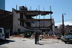
 Westin Peachtree Plaza Hotel tornado damage; the other side of the building had even worse damage. | |
| Meteorological history | |
|---|---|
| Duration | 12 minutes |
| Formed | March 14, 2008, 9:38 p.m. EDT (UTC−04:00) |
| Dissipated | March 14, 2008, 9:50 p.m. EDT (UTC−04:00) |
| EF2 tornado | |
| on the Enhanced Fujita scale | |
| Highest winds | 130 mph (210 km/h) |
| Overall effects | |
| Fatalities | 1 |
| Injuries | 30 |

CNN Center was severely damaged, including shattered windows. The Georgia World Congress Center also sustained serious damage, as was the Omni Hotel, especially the skywalk between the two hotel towers over Andrew Young International Boulevard. This complex alone lost 476 windows, making it necessary to close the south tower to guests. The facades of the Georgia Dome and a Philips Arena parking garage were damaged while hosting basketball games.[64]
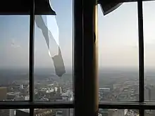
Two of the giant columns in Centennial Olympic Park were knocked down, and insulation was stuck in trees.[65] Trees on some other streets were blown completely down, despite being too early in spring to involve leaf drag. Glass was strewn across several streets, and Atlanta Police kept residents, hotel guests, and news crews away from buildings with falling glass, which continued to pose a danger into the night.[64] Cars in the area were also damaged, and hotel and office furniture was found scattered about.
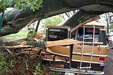
The Ritz Carlton, Westin Peachtree Plaza, Georgia-Pacific Building, SunTrust Plaza (where more than 60 people had to be relocated out of their offices), Equitable Building, and Georgia State University also had windows blown out (300 at Equitable alone), as did The Tabernacle (a former church with stained glass that is now a concert venue). The windows of the Westin continued to fall for days after the tornado, forcing police to keep several city blocks and MARTA's Peachtree Center station closed to pedestrians. The Georgia World Congress Center also sustained flooding while hosting a JROTC event and the Hinman Dental Meeting; Fox Sports Net took footage of a staircase in the new section of the complex that looked like a fountain with water cascading down it. The annual Atlanta Home Show and all other events were cancelled for the weekend in the GWCC complex, as was the Atlanta St. Patrick's Day Parade scheduled for the next day. WRAS FM at Georgia State University was off the air for two days, though it was not stated whether its studio or tower sustained damage, or if this was due to security or safety concerns, or power outages. The historic Rialto Theatre at GSU also sustained roof damage, which caused water damage inside.
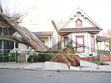
Further east, Grady Hospital reported some damage to windows and a power outage. Many of the injured were taken there, and some walked there and were treated in the emergency room for cuts due to glass. The King Memorial MARTA station was damaged and was being bypassed by trains, with buses rerouted to the next station on each side. Oakland Cemetery suffered major damage to monuments and to its huge oaks and magnolias, and the caretaker found window blinds around the neck of a statue of a Civil War veteran buried there.

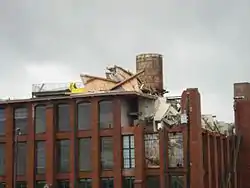
In the nearby Cabbagetown area, a brick loft building (well known for the fire that occurred there in 1999, during its renovation from the Fulton Bag and Cotton Mills, in which the crane operator was rescued by helicopter during live TV news coverage) lost part of its roof, and part of the top (fifth) floor. Another building at The Stacks on Boulevard was damaged; search and rescue personnel were unable to enter, but everyone was accounted for by the management within a few hours.[66]
When the tornado hit, a SEC tournament game between Mississippi State and Alabama which had just been sent into overtime minutes earlier by a shot from Mykal Riley, was in progress at the Georgia Dome and being broadcast live on television. The storm ripped panels from the exterior of the building and tore two holes in the roof of the Dome, causing insulation to fall and the scoreboard and catwalks suspended from the roof to sway; much of this was captured on camera, though the transmission from the arena was interrupted. Riley's shot was considered to have saved lives by keeping people safe inside the Georgia Dome. After a 64-minute delay, the game was completed, however the next scheduled game between Kentucky and Georgia was postponed.[67] The remainder of the tournament games were played at Alexander Memorial Coliseum on the campus of Georgia Tech, with spectators restricted to team and conference personnel, media, team bands, and families of players only due to the much smaller size of the alternate venue.[68] At the nearby Philips Arena, little disruption was noticed by the attendees during the game between the Hawks and the Los Angeles Clippers, even though damage occurred to the outside of the arena.[69]
Twenty-seven people were treated for injuries.[69] In addition, over 20 homes were completely destroyed.[70]
All of CNN's TV networks remained on the air, but there was damage to the glass roof of the CNN Center atrium, flooding part of the food court. Additionally, blown-out windows in the ground floor CNN.com newsroom and the fourth floor videotape library caused minor damage. Live news coverage of the aftermath was carried on CNN International, in turn simulcast domestically on CNN until 1 am EDT.[71] CNN resumed broadcasting from their main newsroom at 6 am EDT, showing several parts of the newsroom with computer stations covered with tarps, the damaged atrium of CNN Center, and staff using trash cans and buckets to collect dripping rainwater to the right of the anchor desk due to the damaged roof. When more storms moved in later in the day, the network was forced to move all Atlanta on-camera operations to the windowless CNN-I studio, while taped programming was shown for most of the day.[72]
The city received emergency assistance from the Georgia Emergency Management Agency (GEMA), Highway Emergency Response Operators (HEROs), Fulton and DeKalb counties (where Atlanta is situated), and surrounding cities and counties. Atlanta Mayor Shirley Franklin also declared a state of emergency for the city [73] and Governor Sonny Perdue issued a state state of emergency declaration [74] for Atlanta enabling the city to seek disaster aid from the Federal Emergency Management Agency (FEMA). President Bush declared a major disaster on March 20.[75]
At the time, it was the most expensive tornado in American history, in raw U.S. dollars, after the 1999 Oklahoma City tornado, costing a half-billion dollars.[76]
See also
Footnotes
- All dates are based on the local time zone where the tornado touched down; however, all times are in Coordinated Universal Time for consistency.
- All damage totals are in 2008 USD unless otherwise stated.
References
- "Tornado slams downtown Atlanta". CNN. March 14, 2008. Archived from the original on 15 March 2008. Retrieved 2008-03-14.
- "Friday tornado pummels downtown; Saturday storm kills 2". Atlanta Journal-Constitution. March 15, 2008. Archived from the original on 9 March 2009. Retrieved 2009-04-19.
- Dial (March 14, 2008). "Mar 15, 2008 0100 UTC Day 1 Convective Outlook". Storm Prediction Center. Retrieved 2008-03-14.
- Dial, Grams (March 15, 2008). "Mar 15, 2008 0600 UTC Day 1 Convective Outlook". Storm Prediction Center. Retrieved 2008-03-16.
- Broyles (March 15, 2008). "Mar 15, 2008 2000 UTC Day 1 Convective Outlook". Storm Prediction Center. Retrieved 2008-03-16.
- "SPC Day 1, 2 and 3 Convective Outlooks". Storm Prediction Center. February 14, 2006. Archived from the original on 2008-05-09. Retrieved 2008-03-16.
- Arkansas Event Report: EF2 Tornado (Report). National Centers for Environmental Information. National Weather Service Weather Forecast Office in Little Rock, Arkansas. 2008. Retrieved January 4, 2017.
- Georgia Event Report: EF2 Tornado (Report). National Centers for Environmental Information. National Weather Service Weather Forecast Office in Atlanta, Georgia. 2008. Retrieved January 5, 2017.
- Georgia Event Report: EF1 Tornado (Report). National Centers for Environmental Information. National Weather Service Weather Forecast Office in Atlanta, Georgia. 2008. Retrieved January 5, 2017.
- Alabama Event Report: EF2 Tornado (Report). National Centers for Environmental Information. National Weather Service Weather Forecast Office in Birmingham, Alabama. 2008. Retrieved January 26, 2017.
- Alabama Event Report: EF2 Tornado (Report). National Centers for Environmental Information. National Weather Service Weather Forecast Office in Birmingham, Alabama. 2008. Retrieved January 26, 2017.
- Georgia Event Report: EF3 Tornado (Report). National Centers for Environmental Information. National Weather Service Weather Forecast Office in Atlanta, Georgia. 2008. Retrieved January 26, 2017.
- Georgia Event Report: EF3 Tornado (Report). National Centers for Environmental Information. National Weather Service Weather Forecast Office in Atlanta, Georgia. 2008. Retrieved January 26, 2017.
- Georgia Event Report: EF3 Tornado (Report). National Centers for Environmental Information. National Weather Service Weather Forecast Office in Atlanta, Georgia. 2008. Retrieved January 26, 2017.
- Georgia Event Report: EF0 Tornado (Report). National Centers for Environmental Information. National Weather Service Weather Forecast Office in Greenville-Spartanburg, South Carolina. 2008. Retrieved January 26, 2017.
- Georgia Event Report: EF0 Tornado (Report). National Centers for Environmental Information. National Weather Service Weather Forecast Office in Greenville-Spartanburg, South Carolina. 2008. Retrieved January 26, 2017.
- South Carolina Event Report: EF0 Tornado (Report). National Centers for Environmental Information. National Weather Service Weather Forecast Office in Greenville-Spartanburg, South Carolina. 2008. Retrieved January 26, 2017.
- South Carolina Event Report: EF0 Tornado (Report). National Centers for Environmental Information. National Weather Service Weather Forecast Office in Greenville-Spartanburg, South Carolina. 2008. Retrieved January 26, 2017.
- South Carolina Event Report: EF1 Tornado (Report). National Centers for Environmental Information. National Weather Service Weather Forecast Office in Columbia, South Carolina. 2008. Retrieved January 26, 2017.
- Georgia Event Report: EF2 Tornado (Report). National Centers for Environmental Information. National Weather Service Weather Forecast Office in Greenville-Spartanburg, South Carolina. 2008. Retrieved January 28, 2017.
- South Carolina Event Report: EF3 Tornado (Report). National Centers for Environmental Information. National Weather Service Weather Forecast Office in Columbia, South Carolina. 2008. Retrieved January 28, 2017.
- South Carolina Event Report: EF1 Tornado (Report). National Centers for Environmental Information. National Weather Service Weather Forecast Office in Columbia, South Carolina. 2008. Retrieved January 28, 2017.
- Georgia Event Report: EF0 Tornado (Report). National Centers for Environmental Information. National Weather Service Weather Forecast Office in Columbia, South Carolina. 2008. Retrieved January 28, 2017.
- South Carolina Event Report: EF1 Tornado (Report). National Centers for Environmental Information. National Weather Service Weather Forecast Office in Columbia, South Carolina. 2008. Retrieved January 28, 2017.
- South Carolina Event Report: EF2 Tornado (Report). National Centers for Environmental Information. National Weather Service Weather Forecast Office in Columbia, South Carolina. 2008. Retrieved January 28, 2017.
- South Carolina Event Report: EF1 Tornado (Report). National Centers for Environmental Information. National Weather Service Weather Forecast Office in Columbia, South Carolina. 2008. Retrieved January 28, 2017.
- South Carolina Event Report: EF1 Tornado (Report). National Centers for Environmental Information. National Weather Service Weather Forecast Office in Columbia, South Carolina. 2008. Retrieved February 3, 2017.
- South Carolina Event Report: EF2 Tornado (Report). National Centers for Environmental Information. National Weather Service Weather Forecast Office in Columbia, South Carolina. 2008. Retrieved February 3, 2017.
- South Carolina Event Report: EF2 Tornado (Report). National Centers for Environmental Information. National Weather Service Weather Forecast Office in Columbia, South Carolina. 2008. Retrieved February 3, 2017.
- South Carolina Event Report: EF2 Tornado (Report). National Centers for Environmental Information. National Weather Service Weather Forecast Office in Columbia, South Carolina. 2008. Retrieved February 3, 2017.
- South Carolina Event Report: EF0 Tornado (Report). National Centers for Environmental Information. National Weather Service Weather Forecast Office in Columbia, South Carolina. 2008. Retrieved February 3, 2017.
- South Carolina Event Report: EF0 Tornado (Report). National Centers for Environmental Information. National Weather Service Weather Forecast Office in Columbia, South Carolina. 2008. Retrieved February 3, 2017.
- South Carolina Event Report: EF2 Tornado (Report). National Centers for Environmental Information. National Weather Service Weather Forecast Office in Columbia, South Carolina. 2008. Retrieved February 3, 2017.
- South Carolina Event Report: EF1 Tornado (Report). National Centers for Environmental Information. National Weather Service Weather Forecast Office in Columbia, South Carolina. 2008. Retrieved February 3, 2017.
- South Carolina Event Report: EF0 Tornado (Report). National Centers for Environmental Information. National Weather Service Weather Forecast Office in Wilmington, North Carolina. 2008. Retrieved February 3, 2017.
- Georgia Event Report: EF0 Tornado (Report). National Centers for Environmental Information. National Weather Service Weather Forecast Office in Columbia, South Carolina. 2008. Retrieved February 3, 2017.
- Georgia Event Report: EF1 Tornado (Report). National Centers for Environmental Information. National Weather Service Weather Forecast Office in Columbia, South Carolina. 2008. Retrieved February 3, 2017.
- South Carolina Event Report: EF2 Tornado (Report). National Centers for Environmental Information. National Weather Service Weather Forecast Office in Columbia, South Carolina. 2008. Retrieved February 4, 2017.
- South Carolina Event Report: EF0 Tornado (Report). National Centers for Environmental Information. National Weather Service Weather Forecast Office in Columbia, South Carolina. 2008. Retrieved February 4, 2017.
- Georgia Event Report: EF0 Tornado (Report). National Centers for Environmental Information. National Weather Service Weather Forecast Office in Atlanta, Georgia. 2008. Retrieved February 4, 2017.
- Georgia Event Report: EF2 Tornado (Report). National Centers for Environmental Information. National Weather Service Weather Forecast Office in Atlanta, Georgia. 2008. Retrieved February 4, 2017.
- Georgia Event Report: EF2 Tornado (Report). National Centers for Environmental Information. National Weather Service Weather Forecast Office in Columbia, South Carolina. 2008. Retrieved February 4, 2017.
- North Carolina Event Report: EF0 Tornado (Report). National Centers for Environmental Information. National Weather Service Weather Forecast Office in Wilmington, North Carolina. 2008. Retrieved February 4, 2017.
- South Carolina Event Report: EF2 Tornado (Report). National Centers for Environmental Information. National Weather Service Weather Forecast Office in Columbia, South Carolina. 2008. Retrieved February 4, 2017.
- South Carolina Event Report: EF0 Tornado (Report). National Centers for Environmental Information. National Weather Service Weather Forecast Office in Columbia, South Carolina. 2008. Retrieved February 4, 2017.
- South Carolina Event Report: EF1 Tornado (Report). National Centers for Environmental Information. National Weather Service Weather Forecast Office in Wilmington, North Carolina. 2008. Retrieved February 4, 2017.
- South Carolina Event Report: EF2 Tornado (Report). National Centers for Environmental Information. National Weather Service Weather Forecast Office in Columbia, South Carolina. 2008. Retrieved February 4, 2017.
- South Carolina Event Report: EF0 Tornado (Report). National Centers for Environmental Information. National Weather Service Weather Forecast Office in Columbia, South Carolina. 2008. Retrieved February 10, 2017.
- South Carolina Event Report: EF1 Tornado (Report). National Centers for Environmental Information. National Weather Service Weather Forecast Office in Columbia, South Carolina. 2008. Retrieved February 10, 2017.
- South Carolina Event Report: EF1 Tornado (Report). National Centers for Environmental Information. National Weather Service Weather Forecast Office in Columbia, South Carolina. 2008. Retrieved February 10, 2017.
- South Carolina Event Report: EF2 Tornado (Report). National Centers for Environmental Information. National Weather Service Weather Forecast Office in Charleston, South Carolina. 2008. Retrieved February 10, 2017.
- South Carolina Event Report: EF0 Tornado (Report). National Centers for Environmental Information. National Weather Service Weather Forecast Office in Wilmington, North Carolina. 2008. Retrieved February 10, 2017.
- South Carolina Event Report: EF1 Tornado (Report). National Centers for Environmental Information. National Weather Service Weather Forecast Office in Wilmington, North Carolina. 2008. Retrieved February 10, 2017.
- South Carolina Event Report: EF1 Tornado (Report). National Centers for Environmental Information. National Weather Service Weather Forecast Office in Columbia, South Carolina. 2008. Retrieved February 10, 2017.
- South Carolina Event Report: EF3 Tornado (Report). National Centers for Environmental Information. National Weather Service Weather Forecast Office in Columbia, South Carolina. 2008. Retrieved February 10, 2017.
- South Carolina Event Report: EF1 Tornado (Report). National Centers for Environmental Information. National Weather Service Weather Forecast Office in Wilmington, North Carolina. 2008. Retrieved February 10, 2017.
- South Carolina Event Report: EF0 Tornado (Report). National Centers for Environmental Information. National Weather Service Weather Forecast Office in Wilmington, North Carolina. 2008. Retrieved February 11, 2017.
- North Carolina Event Report: EF1 Tornado (Report). National Centers for Environmental Information. National Weather Service Weather Forecast Office in Wilmington, North Carolina. 2008. Retrieved February 11, 2017.
- South Carolina Event Report: EF1 Tornado (Report). National Centers for Environmental Information. National Weather Service Weather Forecast Office in Charleston, South Carolina. 2008. Retrieved February 11, 2017.
- South Carolina Event Report: EF1 Tornado (Report). National Centers for Environmental Information. National Weather Service Weather Forecast Office in Charleston, South Carolina. 2008. Retrieved February 11, 2017.
- South Carolina Event Report: EF1 Tornado (Report). National Centers for Environmental Information. National Weather Service Weather Forecast Office in Charleston, South Carolina. 2008. Retrieved February 11, 2017.
- South Carolina Event Report: EF2 Tornado (Report). National Centers for Environmental Information. National Weather Service Weather Forecast Office in Charleston, South Carolina. 2008. Retrieved February 11, 2017.
- South Carolina Event Report: EF2 Tornado (Report). National Centers for Environmental Information. National Weather Service Weather Forecast Office in Charleston, South Carolina. 2008. Retrieved February 11, 2017.
- "Storm Staggers Atlanta". CNN.com. March 14, 2008. Archived from the original on 15 March 2008. Retrieved 2008-03-15.
- "Daylight Reveals Storm's Fury". 11Alive.com. March 14, 2008. Retrieved 2008-03-15.
- "Atlanta tornado, victim search". WCBD.com. March 15, 2008. Retrieved 2008-03-15.
- Schlabach, Mark (March 14, 2008). "SEC tournament delayed as Georgia Dome sustains damage". ESPN.com. Archived from the original on 19 March 2008. Retrieved 15 March 2008.
- "Severe Storms Start Weekend". AccuWeather.com. March 15, 2008. Archived from the original on 14 March 2008. Retrieved 2008-03-15.
- "Weather Service Confirms Tornado Hit Downtown Atlanta". WSB-TV (Atlanta). March 15, 2008. Archived from the original on 18 March 2008. Retrieved 2008-03-15.
- "Rescuers search for Atlanta tornado victims". CNN. March 15, 2008. Archived from the original on 19 March 2008. Retrieved 2008-03-15.
- "Atlanta To Ask For Federal Disaster Aid". wsbtv.com. March 14, 2008. Archived from the original on 18 March 2008. Retrieved 2008-03-15.
- "CNN & The F2 Tornado - TVNewser". 10 September 2012. Archived from the original on 10 September 2012. Retrieved 18 May 2018.
- "Downtown Storm Was EF-2 Tornado; State of Emergency Declared". 11alive.com (Atlanta). Retrieved 2008-03-15.
- "Governor Perdue Declares State of Emergency". State of Georgia, Office of the Governor. March 15, 2008. Archived from the original on May 28, 2010. Retrieved 2009-12-14.
- FEMA: Georgia Severe Storms and Tornadoes Archived 2008-04-11 at the Wayback Machine
- "Search | Atlanta Creative Loafing". Blogs.creativeloafing.com. Retrieved 2018-05-18.
External links
- Possible Tornado Sweeps Through Atlanta - CNN Breaking News Transcript - March 14, 2008
- WSB's coverage of the tornado
- WXIA's coverage of the tornado
- WAGA's coverage of the tornado
- WGCL's coverage of the tornado