A847 road
The A847 road is one of the two principal roads of Islay in the Inner Hebrides off the west coast of mainland Scotland.

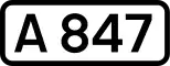
The A847 at Uiskentuie
 | |
|---|---|
| Route information | |
| Length | 14.7 mi[1] (23.7 km) |
| Major junctions | |
| North end | Bridgend 55°46′55″N 6°14′56″W |
| A846 | |
| South end | Portnahaven 55°40′51″N 6°30′23″W |
| Location | |
| Country | United Kingdom |
| Constituent country | Scotland |
| Road network | |
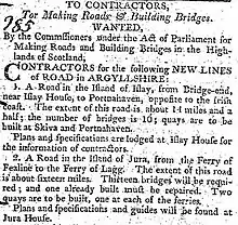
Advertisement for construction from the Caledonian Mercury 18 November 1805
It connects Bridgend, at a junction with the A846 road, with Portnahaven at the southern end of the Rinns of Islay peninsula. It is some 14+1⁄2 miles (23 km) long.
The road was completed in 1806 following the route surveyed by John Langlands of Campbeltown.[2]
Settlements on or near the A847
North to South
- Bridgend
- Blackrock
- Bruichladdich
- Port Charlotte
- Nerabus (Nereabolls)
- Easter Ellister
- Portnahaven
References
- "Driving directions to High St/A847". Google Maps. Retrieved 23 September 2013.
- Walker, Frank Arneil (2005). The Buildings of Scotland. Argyll and Bute. Yale University Press. p. 551. ISBN 9780300096705.
A roads in Zone 8 of the Great Britain road numbering scheme | ||
|---|---|---|
This article is issued from Wikipedia. The text is licensed under Creative Commons - Attribution - Sharealike. Additional terms may apply for the media files.