Äänekoski
Äänekoski (Finnish pronunciation: [ˈæːneˌkːoski]) is a town in Finland. It is located in the Central Finland region, about 45 kilometres (28 mi) north of Jyväskylä. The town has a population of 18,021 (26 October 2023)[5] and covers an area of 1,138.39 square kilometres (439.53 sq mi) of which 253.84 km2 (98.01 sq mi) is water.[1] The population density is 20.37 inhabitants per square kilometre (52.8/sq mi).
Äänekoski | |
|---|---|
Town | |
| Äänekosken kaupunki Äänekoski stad | |
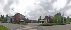 Äänekoski town hall and library | |
 Coat of arms | |
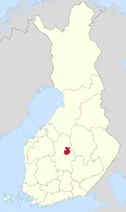 Location of Äänekoski in Finland | |
| Coordinates: 62°36′N 025°43.5′E | |
| Country | |
| Region | Central Finland |
| Sub-region | Äänekoski sub-region |
| Charter | 1932 |
| City rights | 1973 |
| Government | |
| • Town manager | Matti Tuononen |
| Area (2018-01-01)[1] | |
| • Total | 1,138.39 km2 (439.53 sq mi) |
| • Land | 884.54 km2 (341.52 sq mi) |
| • Water | 253.84 km2 (98.01 sq mi) |
| • Rank | 87th largest in Finland |
| Population (2023-10-26)[2] | |
| • Total | 18,021 |
| • Rank | 64th largest in Finland |
| • Density | 20.37/km2 (52.8/sq mi) |
| Population by native language | |
| • Finnish | 98% (official) |
| • Swedish | 0.1% |
| • Others | 1.8% |
| Population by age | |
| • 0 to 14 | 15.2% |
| • 15 to 64 | 56.8% |
| • 65 or older | 27.9% |
| Time zone | UTC+02:00 (EET) |
| • Summer (DST) | UTC+03:00 (EEST) |
| Website | www.aanekoski.fi |
Neighbouring municipalities are Kannonkoski, Konnevesi, Laukaa, Saarijärvi, Uurainen, Vesanto and Viitasaari.
The municipality is unilingually Finnish.[3]
The municipality of Äänekosken maalaiskunta was consolidated to Äänekoski in 1969 and the municipality of Konginkangas in 1993. The municipalities of Sumiainen and Suolahti were consolidated to Äänekoski in 2007.
History

Äänekoski is named after the nearby rapids. Folk etymology connects the name to the word ääni "sound", but Terho Itkonen has suggested another origin: a Sámi term meaning "big, large" (compare Northern Sámi eanas, "most").
Swedish sources mention a salmon fishery by the rapids around 1455, Ænækoski laxefiskeri. At the time, it was not a proper settlement and was located in the hunting grounds of the people of Sysmä. The Rautalampi parish was established in 1561, at the time it was a large parish covering most of Central Finland north of the Päijänne. The Laukaa parish, including the area of Äänekoski, was separated from Rautalampi in 1628.
A settlement named Äänekoski has existed at least since 1752. It remained a part of Laukaa until the parish was established in 1907 and the municipality Äänekosken maalaiskunta was established in 1911. At the time, Äänekosken maalaiskunta was called simply Äänekoski. The municipality was divided in 1932: the actual settlement of Äänekoski became the kauppala of Äänekoski, Suolahti became another kauppala while the old Äänekoski municipality was renamed Äänekosken maalaiskunta and its administrative seat was moved to the village of Honkola. Äänekoski and Äänekosken maalaiskunta still shared a parish.[6]
The first industrial enterprises appeared in 1896–1900.
Four municipalities have been consolidated with Äänekoski: Äänekosken maalaiskunta in 1969, Konginkangas in 1993 and Sumiainen and Suolahti in 2007. Äänekoski adopted the coat of arms of Suolahti in 2007.
Nature
There are altogether 170 lakes in Äänekoski. The biggest lakes are Keitele, Kuhnamo and Niinivesi.[7]
One of the world's smallest rivers, the Kuokanjoki, is within the area.[8] Aatunselkä is also located in this area.[9]
Twin towns – sister cities
The following cities or municipalities are twinned with Äänekoski:[10]
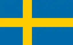 Örnsköldsvik Municipality, Sweden
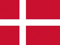 Brande, Brande Municipality, Denmark
 Sigdal, Norway
 Alushta, Alushta municipality, Ukraine
 Borovichi, Novgorod Oblast, Russia (status unknown)
- Sestroretsk, Russia
 Niamey, Niger
Gallery
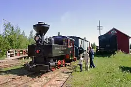 A porter locomotive of the Äänekoski-Suolahti narrow gauge railway
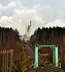 A freight train departing from a pulp mill in Äänekoski
 Kapeenkoski Lock of Keitele–Päijänne canal.
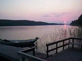 A sunset at Lake Keitele
See also
- Aura cheese – a blue cheese produced in Äänekoski
- Finnish national road 69
References
- "Area of Finnish Municipalities 1.1.2018" (PDF). National Land Survey of Finland. Retrieved 30 January 2018.
- "Preliminary population statistics 2023, September". StatFin. Statistics Finland. Retrieved 26 October 2023.
- "Demographic Structure by area as of 31 December 2022". Statistics Finland's PX-Web databases. Statistics Finland. Retrieved 6 September 2023.
- "Population according to age (1-year) and sex by area and the regional division of each statistical reference year, 2003–2020". StatFin. Statistics Finland. Retrieved 2 May 2021.
- "Population by municipality as of 31 December 2006". Population Information System (in Finnish and Swedish). Population Register Center of Finland. Retrieved 2 May 2010.
- "SuomalainenPaikannimikirja_e-kirja_kuvallinen.pdf" (PDF). kaino.kotus.fi (in Finnish). p. 531. Retrieved 23 August 2022.
- "Äänekoski". Järviwiki. Finland's Environmental Administration. 2012. Retrieved 27 February 2012.
- "Sumiaisten kyläyhdistys". sumiainen.fi. Retrieved 11 April 2022.
- "Aatunselkä (14.332.1.007)". Järvi-meriwiki (in Finnish). 1 February 2011. Retrieved 7 October 2023.
- "Äänekosken kaupungin ystävyyskuntatoiminnan edistäminen" (in Norwegian). City of Äänekoski. Archived from the original on 19 July 2012. Retrieved 1 June 2012.
External links
![]() Media related to Äänekoski at Wikimedia Commons
Media related to Äänekoski at Wikimedia Commons
- Town of Äänekoski – Official website, finnish
Places adjacent to Äänekoski | ||||||||||||||||
|---|---|---|---|---|---|---|---|---|---|---|---|---|---|---|---|---|
| ||||||||||||||||
| Municipalities | ||
|---|---|---|
| Former municipalities | ||