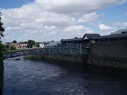
Abbey River, Limerick
The Abbey River (Irish: Abhainn na Mainistreach) is a distributary arm of the River Shannon that flows around the northeastern, eastern, and southern shores of King's Island, Limerick before rejoining the Shannon at Hellsgate Island.[1][2] Hellsgate Island is only visible at low tide.[3] It is bridged by the Abbey Bridge, Baals Bridge, the Canal Bridge, Matthew Bridge, O'Dwyer Bridge, and the Sylvester O'Halloran Footbridge.
| Abbey River | |
|---|---|
 Confluence of the Abbey and Shannon Rivers at Hellsgate Island | |
| Physical characteristics | |
| Source | |
| • location | Distributary of the River Shannon |
| Mouth | |
• location | Atlantic Ocean as the River Shannon |
King's Island's encirclement by the Shannon and Abbey rivers made it a very defensible location, leading to the founding of Limerick as a Viking settlement in the ninth century.[4] The Abbey River has played a defensive role throughout the city's history, not least during the Cromwellian siege of 1650-51,[5] and the Williamite siege of 1691.[6] It is named after the former Franciscan Abbey located next to the river.
In the early 2000s, a number of historical artefacts were discovered when the river was drained. These included Limerick Port seal, intact mortar bombs from the 1690s and a Viking Age bronze artefact, circa AD 1000.[7]
Notes
- Simms, J.G. (1986). War and Politics in Ireland, 1649-1730. London: Hambledon Press. p. 22. ISBN 978-0907628729. Retrieved 23 October 2013.
The Shannon divides at Limerick; a branch, called the Abbey river, makes an island which was called the King's Island.
- "Abbey River, Ireland". Geographical Names. National Geospatial-Intelligence Agency, Bethesda, Maryland, US. 5 May 1998. Archived from the original on 29 October 2013. Retrieved 23 October 2013.
- "Changing Customs and Hunt" (PDF). www.limerickcity.ie. Archived (PDF) from the original on 16 October 2014. Retrieved 31 May 2021.
- Seán Duffy, ed. (1 December 2004). Medieval Ireland: An Encyclopedia. CRC Press. p. 458. ISBN 0203502671.
Viking raiding parties used the Shannon from the 830s, attacking churches along its route and, by mid-century, had established a settlement at Limerick, building a fortress on Inis Sibtond. It was a very strategic site, protected from the west by the Shannon and elsewhere by the Abbey River.
- Lenihan, Maurice (1866). Limerick; Its History and Antiquities, Ecclesiastical, Civil, and Military: From the Earliest Ages, with Copious Historical, Archaeological, Topographical, and Genealogical Notes. Dublin: Hodges, Smith, and Company. p. 175. ASIN B00ECCBH5Y. Retrieved 27 October 2013.
- Burke, James (1 August 2001). "Siege Warfare in Seventeenth Century Ireland". In Lenihan, Pádraig (ed.). Conquest and resistance: war in seventeenth-century Ireland. Brill Academic Publishers. p. 286. ISBN 978-9004117433.
Clearly it was Ginkel's intention to launch an amphibious assault over the Abbey and then cross the boggy ground to the breach…. Such an assault would present many dangers. The river was not fordable and a bridge would have to be constructed under fire.
- McLaughlin, Brian. "Archaeological finds dug up during drainage works on display". The Irish Times. Retrieved 4 November 2021.