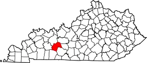
Aberdeen, Kentucky
Aberdeen is an unincorporated community and coal town located in Butler County, Kentucky, United States.
Aberdeen | |
|---|---|
 Aberdeen Location within the state of Kentucky  Aberdeen Aberdeen (the United States) | |
| Coordinates: 37°15′14″N 86°40′54″W | |
| Country | United States |
| State | Kentucky |
| County | Butler |
| Elevation | 541 ft (165 m) |
| Time zone | UTC-6 (Central (CST)) |
| • Summer (DST) | UTC-5 (CDT) |
| ZIP codes | 42201 |
| GNIS feature ID | 485727[1] |
History
Geography
Aberdeen is located in central Butler County, at the junction of U.S. Highway 231 and Kentucky Routes 70 and 79, just across the bridge over the Green River from Morgantown. All three routes lead southwest to Morgantown immediately across the bridge. US 231 leads northwest to Cromwell and Beaver Dam. KY 70 leads east to Roundhill and Brownsville, and KY 79 leads northeast to Caneyville. The community can also be accessed directly from the Exit 33 interchange of Interstate 165 near the Butler/Ohio County line.
Post office
Aberdeen has a local post office with ZIP code 42201.[2][3]
References
- U.S. Geological Survey Geographic Names Information System: Aberdeen, Kentucky
- United States Postal Service. "USPS - Look Up a ZIP Code". Retrieved April 15, 2017.
- "Postmaster Finder - Post Offices by ZIP Code". United States Postal Service. Archived from the original on April 28, 2019. Retrieved April 15, 2017.
This article is issued from Wikipedia. The text is licensed under Creative Commons - Attribution - Sharealike. Additional terms may apply for the media files.
