Abirim
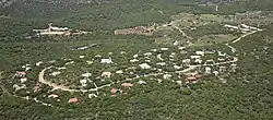
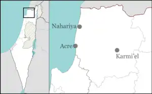
Abirim (Hebrew: אַבִּירִים, lit. Knights), also known as Mitzpe Abirim, is a community settlement in northern Israel. Located in the Upper Galilee, three kilometres from Ma'alot-Tarshiha, it falls under the jurisdiction of Ma'ale Yosef Regional Council. In 2021 it had a population of 296.[1] It is located in the middle of a natural oak forest bordering the Nahal Kziv nature reserve.
Abirim
אַבִּירִים | |
|---|---|
 | |
| Etymology: Knights | |
 Abirim  Abirim | |
| Coordinates: 33°2′22″N 35°17′15″E | |
| Country | |
| District | Northern |
| Council | Ma'ale Yosef |
| Founded | 1980 |
| Population (2021)[1] | 296 |
| Website | abirim.info |
History
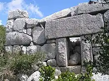
Abirim was established in 1980 and was initially named "Eder" and then renamed to "Abirim" after the nearby ruins of Burj Misr (Arabic: "Egyptian Tower"), which was renamed to Horbat Metsad Abirim (Hebrew: "Ruin of the Fortress of the Knights") in 1957.[2] The age and original purpose of the ruins is unknown; proposals range from a Crusader stronghold to a mausoleum from the Hellenistic period (4th–3rd centuries BCE).[3][4]
See also
References
- "Regional Statistics". Israel Central Bureau of Statistics. Retrieved 22 February 2023.
- Government of Israel, ילקוט הפרסומים (Gazette) number 536, 14 May 1957, p. 856.
- Asher Ovadieh; Yinon Shivtiel (2016). "The caves in the cliff shelters of Keziv Stream (Nahal Keziv) and the relief of 'The Man in the Wall'". Liber Annuus. 66: 351–375. doi:10.1484/J.LA.4.2018015.
- Denys Pringle (1997). Secular Buildings in the Crusader Kingdom of Jerusalem. Cambridge University Press. p. 43.