Adel, Georgia
Adel /ˈeɪdɛl/ is a city in and the county seat of Cook County, Georgia, United States,[4] located fifty-two miles (84 km) southeast of Albany. As of the 2020 census, the city had a population of 5,571.
Adel, Georgia | |
|---|---|
 Adel City Hall, 2012 | |
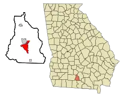 Location in Cook County and the state of Georgia | |
| Coordinates: 31°8′18″N 83°25′33″W | |
| Country | United States |
| State | Georgia |
| County | Cook |
| Government | |
| • Mayor | Buddy Duke |
| Area | |
| • Total | 9.46 sq mi (24.50 km2) |
| • Land | 9.30 sq mi (24.09 km2) |
| • Water | 0.16 sq mi (0.42 km2) |
| Elevation | 240 ft (73 m) |
| Population (2020) | |
| • Total | 5,571 |
| • Density | 599.03/sq mi (231.28/km2) |
| Time zone | UTC-5 (Eastern (EST)) |
| • Summer (DST) | UTC-4 (EDT) |
| ZIP code | 31620 |
| Area code | 229 |
| FIPS code | 13-00576[2] |
| GNIS feature ID | 0354262[3] |
| Website | www |
History
The original name of the city was Puddleville.[5] The city's first postmaster, Joel "Uncle Jack" Parrish, wanted to change the name of the city. It is believed that he saw the name "Philadelphia" on a croaker sack and struck out the first and last four letters to create the present name of Adel.[6]
The Georgia Southern and Florida Railway arrived in Adel in the 1880s.[7] Adel was incorporated as a town in 1889.[8]
Tornadoes
On January 22, 2017, a low-end EF3 tornado struck the extreme southern portion of Adel. Sunshine Acres, a local mobile home park, experienced severe damage, with over 20 homes destroyed and others damaged; seven residents were killed and an indeterminate number were injured or displaced.[9] The tornado ultimately killed 14 people.[10] An EF1 tornado also moved through the city on April 23, 2020[11] On January 22, 2023, a low-end EF2 tornado caused major damage on the north side of town.[12]
Geography
Adel is located just south of the center of Cook County at 31°8′18″N 83°25′33″W (31.138466, -83.425944).[13] It is bordered to the north by Sparks. U.S. Route 41 passes through the center of town as Hutchinson Avenue, and Interstate 75 passes through the western side of the city, with access from Exit 39. Valdosta is 26 miles (42 km) to the south, and Tifton is 23 miles (37 km) to the north.
According to the United States Census Bureau, Adel has a total area of 8.2 square miles (21.3 km2), of which 8.1 square miles (20.9 km2) is land and 0.19 square miles (0.5 km2), or 2.21%, is water.[14]
Demographics
| Census | Pop. | Note | %± |
|---|---|---|---|
| 1890 | 527 | — | |
| 1900 | 721 | 36.8% | |
| 1910 | 1,902 | 163.8% | |
| 1920 | 1,720 | −9.6% | |
| 1930 | 1,796 | 4.4% | |
| 1940 | 2,134 | 18.8% | |
| 1950 | 2,776 | 30.1% | |
| 1960 | 4,321 | 55.7% | |
| 1970 | 4,972 | 15.1% | |
| 1980 | 5,592 | 12.5% | |
| 1990 | 5,093 | −8.9% | |
| 2000 | 5,307 | 4.2% | |
| 2010 | 5,334 | 0.5% | |
| 2020 | 5,571 | 4.4% | |
| U.S. Decennial Census[15] | |||
2020 census
| Race | Num. | Perc. |
|---|---|---|
| Black or African American (non-Hispanic) | 2,485 | 44.61% |
| White (non-Hispanic) | 2,385 | 42.81% |
| Native American | 9 | 0.16% |
| Asian | 61 | 1.09% |
| Pacific Islander | 2 | 0.04% |
| Other/Mixed | 181 | 3.25% |
| Hispanic or Latino | 448 | 8.04% |
As of the 2020 United States census, there were 5,571 people, 2,111 households, and 1,108 families residing in the city.
2000 census
As of the census[2] of 2000, there were 5,307 people, 1,958 households, and 1,335 families residing in the city. The population density was 674.1 inhabitants per square mile (260.3/km2). There were 2,164 housing units at an average density of 274.9 per square mile (106.1/km2). The racial makeup of the city was 48.92% African American, 47.97% White, 0.08% Native American, 0.75% Asian, 0.09% Pacific Islander, 1.43% from other races, and 0.75% from two or more races. Hispanic or Latino of any race were 3.79% of the population.
There were 1,958 households, out of which 33.9% had children under the age of 18 living with them, 43.0% were married couples living together, 20.8% had a female householder with no husband present, and 31.8% were non-families. 27.9% of all households were made up of individuals, and 12.3% had someone living alone who was 65 years of age or older. The average household size was 2.60 and the average family size was 3.17.
In the city, the population was spread out, with 29.4% under the age of 18, 9.4% from 18 to 24, 26.1% from 25 to 44, 20.0% from 45 to 64, and 15.2% who were 65 years of age or older. The median age was 34 years. For every 100 females, there were 86.3 males. For every 100 females age 18 and over, there were 83.5 males.
The median income for a household in the city was $23,908, and the median income for a family was $27,318. Males had a median income of $25,927 versus $19,688 for females. The per capita income for the city was $13,425. About 23.5% of families and 27.4% of the population were below the poverty line, including 36.6% of those under age 18 and 29.2% of those age 65 or over.
Notable people
- Ray McKinnon – actor and producer
- Kaleb Cowart – baseball player (LA Angels 2015–2019)
- Eugene Patterson
Education
Cook County School District
The Cook County School District holds pre-school to grade twelve, and consists of two elementary schools, a middle school, and a high school.[17] The district has 188 full-time teachers and over 3,215 students.[18]
- Cook Primary School
- Cook Elementary School
- Cook Middle School
- Cook High School
Library
Adel is served by the Cook County Public Library.[19]
Climate
The climate in this area is characterized by relatively high temperatures and evenly distributed precipitation throughout the year. According to the Köppen Climate Classification system, Adel has a humid subtropical climate, abbreviated "Cfa" on climate maps.[20]
References
- "2020 U.S. Gazetteer Files". United States Census Bureau. Retrieved December 18, 2021.
- "U.S. Census website". United States Census Bureau. Retrieved January 31, 2008.
- "US Board on Geographic Names". United States Geological Survey. October 25, 2007. Retrieved January 31, 2008.
- "Find a County". National Association of Counties. Archived from the original on May 31, 2011. Retrieved June 7, 2011.
- Krakow, Kenneth K. (1975). Georgia Place-Names. Winship Press, ISBN 9780915430000
- "Adel". Georgia.gov. March 16, 2012. Archived from the original on March 21, 2015. Retrieved March 26, 2019.
- Hellmann, Paul T. (May 13, 2013). Historical Gazetteer of the United States. Routledge. p. 215. ISBN 978-1135948597. Retrieved November 30, 2013.
- "About Us". Adel-Cook County Chamber of Commerce. Archived from the original on March 7, 2018. Retrieved June 11, 2019.
- "Seven Killed In Tornado In Adel GA". WTLV. January 22, 2017. Retrieved January 23, 2017.
- Georgia Event Report: EF3 Tornado (Report). National Centers for Environmental Information. National Weather Service Weather Forecast Office in Tallahassee, Florida. 2017. Retrieved April 20, 2017.Georgia Event Report: EF3 Tornado (Report). National Centers for Environmental Information. National Weather Service Weather Forecast Office in Tallahassee, Florida. 2017. Retrieved April 20, 2017.Georgia Event Report: EF3 Tornado (Report). National Centers for Environmental Information. National Weather Service Weather Forecast Office in Tallahassee, Florida. 2017. Retrieved April 20, 2017.
- Georgia Event Report: EF1 Tornado (Report). National Centers for Environmental Information. National Weather Service in Tallahassee, Florida. 2020. Retrieved January 9, 2023.Georgia Event Report: EF1 Tornado (Report). National Centers for Environmental Information. National Weather Service in Tallahassee, Florida. 2020. Retrieved January 9, 2023.
- National Weather Service in Tallahassee, Florida (January 23, 2023). NWS Damage Survey for 01/22/2023 Tornado Event (Report). Iowa Environmental Mesonet. Retrieved January 23, 2023.
- "US Gazetteer files: 2010, 2000, and 1990". United States Census Bureau. February 12, 2011. Retrieved April 23, 2011.
- "Geographic Identifiers: 2010 Demographic Profile Data (G001): Adel city, Georgia". U.S. Census Bureau, American Factfinder. Archived from the original on February 12, 2020. Retrieved July 30, 2014.
- "Census of Population and Housing". Census.gov. Retrieved June 4, 2015.
- "Explore Census Data". data.census.gov. Retrieved December 18, 2021.
- School Stats Archived 2012-03-23 at the Wayback Machine, Retrieved June 5, 2010.
- "Homepage". Cook County Public Library. Archived from the original on July 29, 2014. Retrieved July 30, 2014.
- "Adel, Georgia Köppen Climate Classification (Weatherbase)". Weatherbase.com. Retrieved March 26, 2019.
External links
- City of Adel official website
- Adel Lime Sink historical marker
Municipalities and communities of Cook County, Georgia, United States | ||
|---|---|---|
| City | 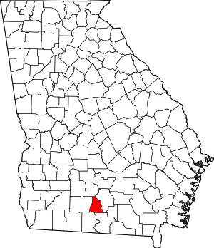 Map of Georgia highlighting Cook County | |
| Towns | ||
| Unincorporated community | ||