Aetomilitsa
Aetomilitsa (Greek: Αετομηλίτσα, before 1927: Δέντσικο - Dentsiko,[2] Aromanian: Densko, Denicko, Denisco) is a village in the Ioannina regional unit, Epirus, Greece. Since the 2011 local government reform it is part of the municipality Konitsa, of which it is a municipal unit.[3] Before 2011, it was an independent community.[2] The 2011 census recorded 432 residents in the village.[1] The community of Aetomilitsa covers an area of 51.297 square kilometres (19.806 sq mi).[4]
Aetomilitsa
| |
|---|---|
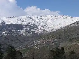
 View on Aetomilitsa village. Peaks of Gramos mountain visible in the background | |
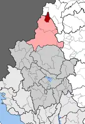
 Aetomilitsa Location within the regional unit  | |
| Coordinates: 40°18.6′N 20°51.3′E | |
| Country | Greece |
| Administrative region | Epirus |
| Regional unit | Ioannina |
| Municipality | Konitsa |
| • Municipal unit | 51.297 km2 (19.806 sq mi) |
| Highest elevation | 1,485 m (4,872 ft) |
| Lowest elevation | 1,385 m (4,544 ft) |
| Population (2011)[1] | |
| • Municipal unit | 432 |
| • Municipal unit density | 8.4/km2 (22/sq mi) |
| Time zone | UTC+2 (EET) |
| • Summer (DST) | UTC+3 (EEST) |
| Postal code | 440 15 |
| Area code(s) | +30-2655-xxx-xxx |
| Vehicle registration | INx-xxxx |
Geography
The village lies on the Gramos mountain. It is one of the highest communities in Greece situated at an altitude between 1,385 and 1,485 metres (4,544 and 4,872 ft). A glacial lake, Moutsalia Lake (Greek: Λίμνη Μουτσάλια) is situated 5 km as the crow flies or 13 km drive on a dirt road from Aetomilitsa.[5]
Climate
Aetomilitsa has a warm-summer humid continental climate (Köppen climate classification: Dfb) using the 0 °C (32 °F) isotherm, or a temperate oceanic climate (Köppen climate classification: Cfb) using the -3 °C (27 °F) isotherm for the coldest month. Aetomilitsa experiences cold winters with high precipitation and warm, drier summers.
| Climate data for Aetomilitsa | |||||||||||||
|---|---|---|---|---|---|---|---|---|---|---|---|---|---|
| Month | Jan | Feb | Mar | Apr | May | Jun | Jul | Aug | Sep | Oct | Nov | Dec | Year |
| Average high °C (°F) | 1.35 (34.43) |
4.05 (39.29) |
8.25 (46.85) |
11.39 (52.50) |
16.83 (62.29) |
20.88 (69.58) |
26.52 (79.74) |
25.39 (77.70) |
21.93 (71.47) |
14.78 (58.60) |
7.53 (45.55) |
3.41 (38.14) |
13.53 (56.35) |
| Daily mean °C (°F) | −1.65 (29.03) |
0.02 (32.04) |
3.11 (37.60) |
7.42 (45.36) |
12.30 (54.14) |
16.16 (61.09) |
20.39 (68.70) |
20.76 (69.37) |
15.45 (59.81) |
8.68 (47.62) |
3.53 (38.35) |
−0.2 (31.6) |
8.83 (47.89) |
| Average low °C (°F) | −5.30 (22.46) |
−3.32 (26.02) |
−1.19 (29.86) |
2.27 (36.09) |
5.86 (42.55) |
9.42 (48.96) |
12.40 (54.32) |
12.10 (53.78) |
7.67 (45.81) |
4.39 (39.90) |
−0.86 (30.45) |
−4.04 (24.73) |
3.28 (37.91) |
| Average precipitation mm (inches) | 144.84 (5.70) |
144.48 (5.69) |
115.25 (4.54) |
105.99 (4.17) |
111.82 (4.40) |
66.35 (2.61) |
51.45 (2.03) |
58.93 (2.32) |
54.78 (2.16) |
103.68 (4.08) |
155.22 (6.11) |
172.09 (6.78) |
1,284.88 (50.59) |
| Mean monthly sunshine hours | 119.09 | 125.85 | 154.85 | 162.02 | 205.07 | 275.09 | 295.31 | 270.15 | 200.00 | 167.03 | 113.25 | 85.92 | 2,173.63 |
| Source: Hellenic National Meteorological Service[6] | |||||||||||||
History
Aetomilitsa is today inhabited mainly by Aromanians (Vlachs) who are Greek Orthodox Christians. For a time during the Greek Civil War (1946-1949), Aetomilitsa was the seat of the communist rebels, the so-called "Provisional Democratic Government".[7]
References
- "Απογραφή Πληθυσμού - Κατοικιών 2011. ΜΟΝΙΜΟΣ Πληθυσμός" (in Greek). Hellenic Statistical Authority.
- "EETAA local government changes". Retrieved 26 June 2020.
- "ΦΕΚ B 1292/2010, Kallikratis reform municipalities" (in Greek). Government Gazette.
- "Population & housing census 2001 (incl. area and average elevation)" (PDF) (in Greek). National Statistical Service of Greece. Archived from the original (PDF) on 2015-09-21.
- "Fourwheel drive to Grammos - Lake Moutsalia". Retrieved 2020-01-06.
- "Kalarites Climatic Data". Hellenic National Meteorological Service. Retrieved 14 March 2021.
- Shrader, Charles R. (1999). The Withered Vine: Logistics and the Communist Insurgency in Greece, 1945-1949. Greenwood Publishing Group. p. 6. ISBN 9780275965440.