Danakil Desert
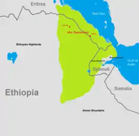
The Danakil Desert (or Afar Desert) is a desert in northeast Ethiopia, southern Eritrea, and northwestern Djibouti. Situated in the Afar Triangle, it stretches across 136,956 square kilometres (52,879 sq mi) of arid terrain. It is inhabited by a few Afar, who engage in salt mining. The area is known for its volcanoes and extreme heat, with daytime temperatures surpassing 50 °C (122 °F).[1] Less than 25 mm (1 in) of rainfall occurs each year.[2] The Danakil Desert is one of the lowest and hottest places on Earth.
| Danakil Desert | |
|---|---|
 | |
| Area | 136,956 km2 (52,879 sq mi) |
| Geography | |
| Country | Ethiopia, Eritrea, Djibouti |
| Coordinates | 14.2417°N 40.3°E |
Climate
Dallol (92 metres below sea level), has the highest average temperature recorded on earth:
| Climate data for Dallol (1960-1966) | |||||||||||||
|---|---|---|---|---|---|---|---|---|---|---|---|---|---|
| Month | Jan | Feb | Mar | Apr | May | Jun | Jul | Aug | Sep | Oct | Nov | Dec | Year |
| Record high °C (°F) | 39 (102) |
42 (108) |
48 (118) |
46 (115) |
49 (120) |
48 (119) |
49 (121) |
48 (119) |
48 (119) |
46 (115) |
44 (111) |
41 (106) |
49 (121) |
| Average high °C (°F) | 36.1 (97.0) |
36.1 (97.0) |
38.9 (102.0) |
40.6 (105.1) |
44.4 (111.9) |
46.7 (116.1) |
45.6 (114.1) |
45.0 (113.0) |
42.8 (109.0) |
41.7 (107.1) |
39.4 (102.9) |
36.7 (98.1) |
41.2 (106.1) |
| Daily mean °C (°F) | 30.3 (86.5) |
30.5 (86.9) |
32.5 (90.5) |
33.9 (93.0) |
36.4 (97.5) |
38.6 (101.5) |
38.7 (101.7) |
37.6 (99.7) |
37.3 (99.1) |
35.6 (96.1) |
33.2 (91.8) |
30.8 (87.4) |
34.6 (94.3) |
| Average low °C (°F) | 24.6 (76.3) |
24.6 (76.3) |
26.0 (78.8) |
27.1 (80.8) |
28.5 (83.3) |
30.4 (86.8) |
31.8 (89.2) |
31 (88) |
31.6 (88.8) |
29.6 (85.3) |
27.1 (80.8) |
25.7 (78.3) |
28.2 (82.7) |
| Record low °C (°F) | 22 (72) |
22 (72) |
21 (70) |
21 (70) |
23 (73) |
25 (77) |
24 (75) |
24 (75) |
27 (81) |
26 (79) |
24 (75) |
24 (75) |
21 (70) |
| Source: [3][4] | |||||||||||||
Geology
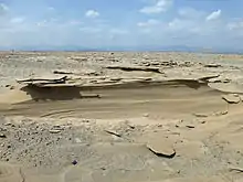
Local geology is characterized by volcanic and tectonic activity, various climate cycles, and discontinuous erosion. The basic geological structure of this area was caused by the movement of tectonic plates as Africa moved away from Asia. Mountain chains formed and were eroded again during the Paleozoic. Inundations by the sea caused the formation of layers of sandstone, and limestone was deposited further offshore. As the land rose again, further sandstone formed above the limestone. Further tectonic shifts caused lava to pour out of cracks and cover the sedimentary deposits.[2]
The Danakil Desert has a number of lakes formed by lava flows that dammed up several valleys. Among these is Lake Afrera, which has thick saline crusts on its banks.[5] Other areas of the Danakil became sinks, dry endorheic basins as precipitation evaporates faster than it can collect in permanent lakes. The area is flanked toward the east by the Danakil Alps, a tabular mountain system that has a few volcanic cones which peak in height in Mount Ramlo (2,130 metres (6,990 ft)).
The land surrounding the Danakil Depression was once part of the Red Sea. The salt deposits were created when water from the Red Sea flooded the area and then evaporated. The most recent flood was roughly 30,000 years ago. While the water is gone, salt remains in extraordinarily large quantities, and has proven to be a valuable — and fatal — commodity for locals.[5]
A deposit of salt up to 800 metres (2,600 ft) thick can also be found in the Salt Plain flatlands. Other local lakes include Lake Asale (116 metres (381 ft) below sea level) and Lake Giuletti/Afrera 80 metres (260 ft) below sea level, both of which possess cryptodepressions in the Danakil Depression. The Afrera contains many active volcanoes, including the Maraho, Dabbahu, Afdera and Erta Ale.[2][6]
Human presence
In 1974, anthropologists discovered an Australopithecus afarensis body at Hadar, Ethiopia in the Awash Valley. The body was found to be female and named Lucy.[5]
The Afar people mine salt, loading each of their camels with up to thirty salt bricks weighing four kilograms each. It will then take two days to get to the nearest town, with guards watching the camels and guarding them from bandits.[7] There is a project to flood the depression by carrying out a channel from the ocean. In the past, salt was used as a form of currency in the region, but now the miners use regular cash to conduct transactions.[5]
See also
References
- Yee, Amy (30 January 2017). "Gazing Into Danakil Depression's Mirror, and Seeing Mars Stare Back". The New York Times. Retrieved 31 January 2017.
- Marco Stoppato, Alfredo Bini (2003). Deserts. Firefly Books. pp. 160–163. ISBN 1552976696. Retrieved 17 September 2014.
- D.E. Pedgley, "Air Temperature at Dallol, Ethiopia," Meteorological Magazine v.96 (1967): 265-271
- "Allana Potash Corp, Ethiopia Project" (PDF). Environmental Resources Management. Archived from the original (PDF) on 20 November 2015. Retrieved 11 August 2014.
- atlasofhumanity.com. "Ethiopia, Danakil Desert". Atlas Of Humanity. Retrieved 2023-07-04.
- Facts On File, Incorporated (2009). Encyclopedia of the Peoples of Africa and the Middle East. Infobase Publishing. p. 7. ISBN 978-1438126760. Retrieved 17 September 2014.
- "Inside Ethiopia's sizzling cauldron". BBC. Retrieved 22 November 2016.