Aisey-sur-Seine
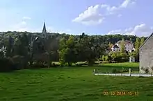
Aisey-sur-Seine (French pronunciation: [ɛzɛ syʁ sɛn], literally Aisey on Seine) is a commune in the Côte-d'Or department in the Bourgogne-Franche-Comté region of eastern France.
Aisey-sur-Seine | |
|---|---|
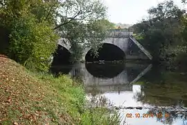 The Bridge of Troubles on the Seine at Aisey-sur-Seine | |
 Coat of arms | |
Location of Aisey-sur-Seine | |
 Aisey-sur-Seine  Aisey-sur-Seine | |
| Coordinates: 47°45′04″N 4°34′52″E | |
| Country | France |
| Region | Bourgogne-Franche-Comté |
| Department | Côte-d'Or |
| Arrondissement | Montbard |
| Canton | Châtillon-sur-Seine |
| Intercommunality | Pays Châtillonnais |
| Government | |
| • Mayor (2020–2026) | Gérard Eme[1] |
| Area 1 | 12.72 km2 (4.91 sq mi) |
| Population | 172 |
| • Density | 14/km2 (35/sq mi) |
| Time zone | UTC+01:00 (CET) |
| • Summer (DST) | UTC+02:00 (CEST) |
| INSEE/Postal code | 21006 /21400 |
| Elevation | 251–379 m (823–1,243 ft) (avg. 264 m or 866 ft) |
| 1 French Land Register data, which excludes lakes, ponds, glaciers > 1 km2 (0.386 sq mi or 247 acres) and river estuaries. | |
The inhabitants of the commune are known as Aiseyens or Aiseyennes.[3]
Geography
Aisey-sur-Seine is located some 12 km south of Chatillon-sur-Seine and about 25 km north-east of Montbard. The commune can be reached by travelling east from Coulmier-le-Sec on Highway D29 which passes through the heart of the commune and the town before continuing east to join Highway D16 near Saint-Germain-le-Rocheux. The commune can also be accessed from the north on Highway D971 (the Route de Dijon) from Nod-sur-Seine. Highway D971 continues through the town and commune south to Saint-Marc-sur-Seine. Other highways entering the commune are the D101A from Chemin-d'Aisey in the south-west and the D29C cross-country road from Nod-sur-Seine which joins Highway D29 in the commune. The commune has large areas of forest - especially in the east and the south with some farmland on the western side.[4]
The commune is traversed by the Seine river which forms part of the south-eastern boundary before passing northwards through the town then along a part of the northern border before continuing north to Chamesson. The Brevon Stream which forms the south-eastern boundary of the commune joins the Seine near the intersection of Highway D29 and D101 (a side road from the D971).[4]
Neighbouring Communes and Villages
Places adjacent to Aisey-sur-Seine | |
|---|---|
History
Formerly known as Aisey-le-Duc.
In the Middle Ages, Aisey-sur-Seine was the seat of a lordship. There is a well-preserved Fortified house with a game park.[5]
Heraldry
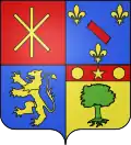
Arms of Aisey-sur-Seine |
The official status of the blazon remains to be determined.
The arms of the commune of Abos are blazoned : Quarterly, first of Gules a saltire couped debruised by a pallet couped, all of Or; the second Azure of three fleurs-de-lis of Or 2 and 1 and a bendlet couped of Gules; the third Azure with lion of Or; the fourth Or with a tree Vert eradicated in chief Gules charged with a mullet of Or between two roundels the same.
|
Administration

List of Successive Mayors of Aisey-sur-Seine[6]
| From | To | Name | Party | |
|---|---|---|---|---|
| 1995 | 2001 | Pierre Mars | ||
| 2001 | 2008 | Jean Abord-Hugon | ind. | |
| 2008 | 2026 | Gérard Ème |
Population
| Year | Pop. | ±% p.a. |
|---|---|---|
| 1968 | 219 | — |
| 1975 | 150 | −5.26% |
| 1982 | 147 | −0.29% |
| 1990 | 172 | +1.98% |
| 1999 | 196 | +1.46% |
| 2007 | 218 | +1.34% |
| 2012 | 199 | −1.81% |
| 2017 | 176 | −2.43% |
| Source: INSEE[7] | ||

Culture and heritage
Civil heritage
The commune has many buildings and structures that are registered as historical monuments:
- A Lavoir (Public laundry) and the Fountain of April (1846)
 [8]
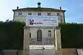
[8] - The Maison Huguenin Hospice and Charity House (1846)[9]
- A House (1) at Grande Rue (19th century)[10]
- A House (2) at Grande Rue (19th century)[11]
- A House at Rue Haute (19th century)[12]
- A Flour Mill at Rue du Pont (19th century)[13]
- A Lavoir (Public laundry) at Rue du Pont (18th century)[14]
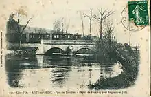
- A Bridge at Rue du Pont (17th century)[15]
- The Chateau de Tavannes at RN 71 (15th century)[16][17]
- The Bridge of Troubles at RN 71 (17th century)[18]
- A House at Rue Rougeot (19th century)[19]
- A Lavoir (Public laundry) and Drinking Trough at Grande Rue (19th century)[20]
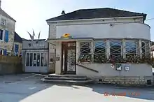
- The Town Hall / School at Grande Rue (19th century)[21]
- Houses (19th century)[22]
- The Chateau of the Dukes of Burgundy at La Barque (12th century)[23]
Religious heritage
The commune has several religious buildings and structures that are registered as historical monuments:
- A Cemetery Cross at Chemin des Chenevières (19th century)[24]
- A Cemetery at Chemin des Chenevières (19th century)[25]
- A Wayside Cross at CVO 3 and CR 7 crossroads (1826)[26]
- A Wayside Cross at Rue de la Poterne and CR 18 crossroads (1866)[27]
- A Wayside Cross at RD 29 and RD 101a crossroads (1830)[28]
- A Wayside Cross at Grande Rue (1767)[29]
- A Presbytery at Grande Rue (18th century)[30]
- The Parish Church of Saint-Genest at Grande Rue (19th century).[31] The church contains a very large number of items that are registered as historical objects.[31]
Gallery of Historical Monuments
 The Maison Huguenin Hospice and Charity House
 The Flour Mill at Rue du Pont
 The Lavoir (Public laundry) at Rue du Pont
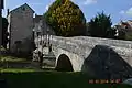 The Bridge at Rue du Pont
 The Chateau de Tavannes
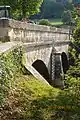 The Bridge of Troubles
 The Cemetery Cross at Chemin des Chenevières
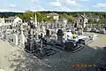 The Cemetery at Chemin des Chenevières
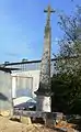 The Wayside Cross at Rue de la Poterne and CR 18 crossroads
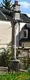 The Wayside Cross at Grande Rue
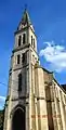 The Church of Saint-Genest
See also
References
- "Répertoire national des élus: les maires" (in French). data.gouv.fr, Plateforme ouverte des données publiques françaises. 13 September 2022.
- "Populations légales 2020". The National Institute of Statistics and Economic Studies. 29 December 2022.
- Inhabitants of Côte-d'Or (in French)
- Google Maps
- Élisabeth Sirot, Noble and Fortified houses - the lordly habitats in the Middle Ages from the mid-12th to the beginning of the 16th centuries, Editions Picard, 2007, ISBN 978-2-7084-0770-1, passage 71.
- List of Mayors of France (in French)
- Population en historique depuis 1968, INSEE
- Ministry of Culture, Mérimée IA00096232 Lavoir and Fountain of April (in French)
- Ministry of Culture, Mérimée IA00096241 Maison Huguenin Hospice and Charity House (in French)

- Ministry of Culture, Mérimée IA00096240 House (1) at Grande Rue (in French)
- Ministry of Culture, Mérimée IA00096314 House (2) at Grande Rue (in French)
- Ministry of Culture, Mérimée IA00096313 House at Rue Haute (in French)
- Ministry of Culture, Mérimée IA00096311 Flour Mill at Rue du Pont (in French)
- Ministry of Culture, Mérimée IA00096233 Lavoir at Rue du Pont (in French)
- Ministry of Culture, Mérimée IA00096229 Bridge at Rue du Pont (in French)
- Ministry of Culture, Mérimée IA00096366 Chateau de Tavannes (in French)
- Ministry of Culture, Mérimée PA00112052 Chateau de Tavannes (in French)
- Ministry of Culture, Mérimée IA00096228 Bridge of Troubles at RN 71 (in French)
- Ministry of Culture, Mérimée IA00096315 House at Rue Rougeot (in French)
- Ministry of Culture, Mérimée IA00096231 Lavoir and Drinking Trough at Grande Rue (in French)
- Ministry of Culture, Mérimée IA00096227 Town Hall / School at Grande Rue (in French)
- Ministry of Culture, Mérimée IA00096312 Houses (in French)
- Ministry of Culture, Mérimée IA00096226 Chateau of the Dukes of Burgundy at La Barque (in French)
- Ministry of Culture, Mérimée IA00096239 Cemetery Cross at Chemin des Chenevières (in French)
- Ministry of Culture, Mérimée IA00096234 Cemetery at Chemin des Chenevières (in French)
- Ministry of Culture, Mérimée IA00096235 Wayside Cross at CVO 3 and CR 7 crossroads (in French)
- Ministry of Culture, Mérimée IA00096236 Wayside Cross at Rue de la Poterne and CR 18 crossroads (in French)
- Ministry of Culture, Mérimée IA00096238 Wayside Cross at RD 29 and RD 101a crossroads (in French)
- Ministry of Culture, Mérimée IA00096237 Wayside Cross at Grande Rue (in French)
- Ministry of Culture, Mérimée IA00096230 Presbytery at Grande Rue (in French)
- Ministry of Culture, Mérimée IA00096225 Parish Church of Saint-Genest at Grande Rue (in French)
External links
- Aisey-sur-Seine on Géoportail, National Geographic Institute (IGN) website (in French)
- Aifey le Duc on the 1750 Cassini Map