Akdağmadeni District
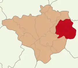
Akdağmadeni District is a district of the Yozgat Province of Turkey. Its seat is the town of Akdağmadeni.[1] Its area is 1,810 km2,[2] and its population is 41,577 (2022).[3] The district of Akdağmadeni is located in the east of the Yozgat province. It is surrounded to the north by the district of Kadışehri, in the south by Çayıralan, Sarikaya and Saraykent in the west and the Sarkisla district in the east.
Akdağmadeni District | |
|---|---|
 Map showing Akdağmadeni District in Yozgat Province | |
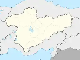
 Akdağmadeni District Location in Turkey  Akdağmadeni District Akdağmadeni District (Turkey Central Anatolia) | |
| Coordinates: 39°40′N 35°53′E | |
| Country | Turkey |
| Province | Yozgat |
| Seat | Kadışehri |
| Government | |
| • Kaymakam | Fatih Topuz |
| Area | 1,810 km2 (700 sq mi) |
| Population (2022) | 41,577 |
| • Density | 23/km2 (59/sq mi) |
| Time zone | TRT (UTC+3) |
| Website | www |
Climate
The district is situated in the central Anatolian plateau and shares its climatic peculiarities. Summers are very hot, winters are not extremely cold. Snowfall can be detected as soon as in mid-November. The average annual rainfall lies between 478 and 500 millimeters. In summer, temperatures are between 20 and 25 degrees Celsius. The annual average temperature varies between 8 and 12 degrees. Generally, the climate is quite damp. Winds blow mostly from the east and south. North wind against the mountains is a protective case.
Composition
There are two municipalities in Akdağmadeni District:[1][4]
There are 78 villages in Akdağmadeni District:[5]
- Abdurrahmanlı
- Ağaçlı
- Akbaş
- Akçakışla
- Akçakoyunlu
- Alicik
- Altılı
- Ardıçalanı
- Arpalık
- Arslanlı
- Aşağıçulhalı
- Bahçecik
- Başçatak
- Boğazköy
- Boyalık
- Bozhüyük
- Bulgurlu
- Çağlayan
- Çampınar
- Çardak
- Çaypınar
- Çerçialanı
- Davulbaz
- Davutlu
- Dayılı
- Demirşeyh
- Dereyurt
- Dokuzköy
- Dolak
- Evci
- Eynelli
- Gökdere
- Güllük
- Gümüşdibek
- Gündüzler
- Hacıfakılı
- Halhacı
- Hayran
- Hüyüklüalanı
- İbrahimağaçiftliği
- Karaalikaçağı
- Karacaören
- Karadikmen
- Karapir
- Kartal
- Kayabaşı
- Kayakışla
- Kılıçlı
- Kırlar
- Kirsinkavağı
- Kızılcaova
- Kızıldağ
- Körük
- Kuşlukaçağı
- Melikli
- Muşalikalesi
- Okçulu
- Örenkale
- Ortaköy
- Özer
- Paşabey
- Pazarcık
- Sağıroğlu
- Şahnaderesi
- Sarıgüney
- Sazlıdere
- Sekikaşı
- Tarhana
- Taşpınar
- Tekkegüney
- Üçkaraağaç
- Uzakçay
- Veziralanı
- Yazılıtaş
- Yedişehri
- Yeniyapan
- Yukarıçulhalı
- Yünalanı
References
- İlçe Belediyesi, Turkey Civil Administration Departments Inventory. Retrieved 22 May 2023.
- "İl ve İlçe Yüz ölçümleri". General Directorate of Mapping. Retrieved 22 May 2023.
- "Address-based population registration system (ADNKS) results dated 31 December 2022, Favorite Reports" (XLS). TÜİK. Retrieved 22 May 2023.
- Belde Belediyesi, Turkey Civil Administration Departments Inventory. Retrieved 22 May 2023.
- Köy, Turkey Civil Administration Departments Inventory. Retrieved 22 May 2023.
