Qalyubiyya Governorate
Qalyubia Governorate (Arabic: محافظة القليوبية Moḥāfaẓat El Qalyubiyya Egyptian Arabic pronunciation: [elʔæljoˈbejjæ]) is one of the governorates of Egypt. Located in Lower Egypt. It is situated north of Cairo in the Nile Delta region. Its capital is Banha.
Qalyubia Governorate | |
|---|---|
 Flag | |
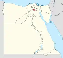 Qalyubia Governorate on the map of Egypt | |
| Coordinates: 30.41°N 31.21°E | |
| Country | |
| Seat | Benha (capital) |
| Government | |
| • Governor | Alaa Abdul-Halim Mohammed Marzouk[1] |
| Area | |
| • Total | 1,001 km2 (386 sq mi) |
| Population (January 2023)[3] | |
| • Total | 6,103,039 |
| • Density | 6,100/km2 (16,000/sq mi) |
| Time zone | UTC+2 (EET) |
| HDI (2021) | 0.735[4] high · 11th |
| Website | www |
Name
The name of Qalubiyya governorate is derived from Qalyub city in it. Qalyub is derived from Calliope.[5] Calliope[5] is an ancient Greek goddess,the Muse of epic poetry.[5]
Geography
Banha and several other settlements blend into the neighboring Cairo Governorate; as a result, parts of Qalyubia (particularly Shubra El Kheima) are generally considered to form part of the Greater Cairo metropolitan area (along with Cairo governorate, Giza city and 6 October city).
| Year | Pop. | ±% |
|---|---|---|
| 1937 | 610,157 | — |
| 1947 | 693,908 | +13.7% |
| 1957 | 758,000 | +9.2% |
| 1966 | 1,212,000 | +59.9% |
| 1976 | 1,674,006 | +38.1% |
| 1986 | 2,514,244 | +50.2% |
| 1996 | 3,302,860 | +31.4% |
| 2006 | 4,237,003 | +28.3% |
| 2015 | 5,105,972 | +20.5% |
| 2023 | 6,103,039 | +19.5% |
| 1937–2023, 2015 is an estimate[6][3] | ||
Municipal divisions
The governorate is divided into the following municipal divisions for administrative purposes, with a total estimated population as of January 2023 of 6,103,039. In some instances there is a markaz and a kism with the same name.[3]
| Anglicized name | Native name | Arabic transliteration | Population (January 2023 Est.) | Type |
|---|---|---|---|---|
| Khanka | قسم الخانكه | Al-Khānkah | 83,420 | Kism (fully urban) |
| Khanka | مركز الخانكة | Al-Khānkah | 618,189 | Markaz |
| Khusus | قسم الخصوص | Al-Khuṣūṣ | 499,514 | Kism (fully urban) |
| El Qanater El Khayreya | مركز القناطر الخيرية | Al-Qanāṭir al-Khayriyah | 546,560 | Markaz |
| El Ubour | قسم العبور | Al-'Ubūr | 142,003 | Kism (fully urban) |
| Banha | مركز بنها | Banhā | 519,640 | Markaz |
| Banha 1 | قسم اول بنها | Banhā 1 | 116,113 | Kism (fully urban) |
| Banha 2 | قسم ثان بنها | Banhā 2 | 70,105 | Kism (fully urban) |
| Kafr Shukr[7] | مركز كفر شكر | Kafr Shukr | 203,522 | Markaz |
| Qaha | قسم قها | Qahā | 51,917 | Kism (urban and rural parts) |
| Qalyub | قسم قليوب | Qalyūb | 159,760 | Kism (fully urban) |
| Qalyub | مركز قليوب | Qalyūb | 603,868 | Markaz |
| Shubra El Kheima 1 | قسم أول شبرا الخيمة | Shubrā al-Khaymah 1 | 525,812 | Kism (fully urban) |
| Shubra El Kheima 2 | قسم ثان شبرا الخيمة | Shubrā al-Khaymah 2 | 741,395 | Kism (fully urban) |
| Shibin El Qanater | مركز شبين القناطر | Sibīn al-Qanāṭir | 581,892 | Markaz |
| Tukh | مركز طوخ | Ṭūkh | 639,329 | Markaz |
Population
According to population estimates, in 2015 the majority of residents in the governorate lived in rural areas, with an urbanization rate of only 44.7%. Out of an estimated 5,105,972 people residing in the governorate, 2,825,045 people lived in rural areas as opposed to only 2,280,927 in urban areas.[8]
Cities
The cities in the Qalyubia Governorate are:
Industrial zones
According to the Egyptian Governing Authority for Investment and Free Zones (GAFI), in affiliation with the Ministry of Investment (MOI), the following industrial zones are located in this governorate:[9]
- Al Shorouk
- Al Safa
- Al Aqrasha
- (New urban community) Al Obour industrial zone
Economy
Qalyubia is known for its agricultural production of crops, fruits and vegetables. The most important of these crops include maize, cotton, wheat, citrus fruits, bananas, oranges and apricots. Qalyubia is also the leading Egyptian governorate in the production of poultry and eggs.[2]
Programs and projects
In 1981, the Basic Village Service Program (BVS) had several water projects going on in the Qalyubia Governorate.[10]
In a program that began on August 28, 2012 (through 2018), the European Union invested 40 million Euros on upgrading the infrastructure of informal areas in Qalyubia Governorate.[11]
References
- "رسمياً.. المحافظون الجدد ونوابهم يؤدون اليمين الدستورية أمام الرئيس". Almasry Alyoum (in Arabic). 30 August 2018. Archived from the original on 31 August 2018. Retrieved 31 August 2018.
- "Al-Qalyūbiyyah GOVERNORATE, EGYPT". britannica.
- "ﻋـــﺩﺩ ﺍﻟﺳﻛــﺎﻥ ﺍﻟﺗﻘﺩﻳﺭﻯ ﻟﻸﻗﺳــﺎﻡ" (PDF) (in Arabic). Retrieved 1 April 2023.
- "Sub-national HDI - Subnational HDI - Table - Global Data Lab". globaldatalab.org. Retrieved 20 February 2023.
- "Calliope | Greek Muse". Encyclopedia Britannica. Retrieved 15 June 2021.
- "Population History (Al Qalyūbīyah)Population, 1966–2006". Statoids. Archived from the original on 14 October 2016. Retrieved 16 October 2016.
- "Markaz Kafr Shukr". Google Map.
- "Population Estimates By Sex & Governorate 1/1/2015" (PDF). CAPMAS. Archived (PDF) from the original on 19 October 2015. Retrieved 23 October 2016.
- "Industrial Zones of Governorate". Ministry of Investment Egypt. Archived from the original on 23 November 2018. Retrieved 23 November 2018.
- "Egypt: The Basic Village Services Program" (PDF). USAID. Archived (PDF) from the original on 19 October 2016. Retrieved 19 October 2016.
- "Upgrading Informal Areas in the Greater Cairo Region". European Union External Action. Archived from the original on 2 January 2017. Retrieved 2 January 2017.
External links
| Urban | ||
|---|---|---|
| Lower Egypt | ||
| Upper Egypt | ||
| Frontier | ||