Aldan (river)
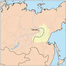
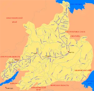
The Aldan (Sakha and Russian: Алдан) is the second-longest, right tributary of the Lena in the Sakha Republic in eastern Siberia.[1] The river is 2,273 kilometres (1,412 mi) long, of which around 1,600 kilometres (990 mi) is navigable. It has a drainage basin of 729,000 square kilometres (281,000 sq mi).[2]
| Aldan | |
|---|---|
_-_panoramio.jpg.webp) The Aldan by the Kyllakh Range | |
 Map of the Aldan River course | |
| Location | |
| Country | Russia |
| Physical characteristics | |
| Source | Stanovoy Mountains |
| • location | Neryungri, Sakha |
| • coordinates | 56°29′06″N 123°44′02″E |
| • elevation | 1,224 m (4,016 ft) |
| Mouth | Lena |
• location | Sakha |
• coordinates | 63°26′46″N 129°33′13″E |
• elevation | 43 m (141 ft) |
| Length | 2,273 km (1,412 mi) |
| Basin size | 729,000 km2 (281,000 sq mi) |
| Discharge | |
| • average | 5,489 m3/s (193,800 cu ft/s) (near mouth) |
| Basin features | |
| Progression | Lena→ Laptev Sea |
| Tributaries | |
| • left | Amedichi, Amga |
| • right | Timpton, Uchur, Maya, Allakh-Yun |
The river was part of the River Route to Okhotsk. In 1639 Ivan Moskvitin ascended the rivers Aldan and Maya and crossed to the Ulya to reach the Sea of Okhotsk.
Course
The Aldan rises in the Stanovoy Mountains southwest of Neryungri. It flows roughly in a northeast / ENE direction south of the Lena Plateau across the Aldan Highlands, where it forms the northern border of the Sunnagyn Range. Then it flows past Aldan and through Tommot, Ust-Maya, Eldikan and Khandyga before turning northwest. In its last stretch it flanks the southern slopes of the Verkhoyansk Range and joins the Lena near Batamay.[3]
See also
References
- Zvegintzov, Nicholas; Yates, Anthol (2001). Siberian BAM Guide: Rail, River & Road. Rail Guides Series. Trialblazer Publications. ISBN 9781873756188.
External links
 Media related to Aldan River at Wikimedia Commons
| Branches |
| ||||||||
|---|---|---|---|---|---|---|---|---|---|
| Techniques and tools |
| ||||||||
| Institutions |
| ||||||||
| Education | |||||||||
 | ||