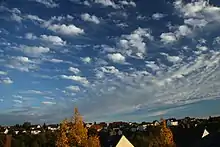
Altocumulus floccus
Altocumulus floccus is a cloud type named for its tuft-like, wooly appearance.[1] The base of the cloud can form as low as 2,000 metres (6,600 ft), or as high as 6,000 metres (20,000 ft). They often form in clusters, or patches, and bases can vary in height with differing atmospheric conditions within the PBL.[2] They are similar to Altocumulus castellanus, but often have a shallower vertical extent in comparison.[3]
| Altocumulus floccus | |
|---|---|
 Altocumulus floccus over Germany in October 2010 | |
| Abbreviation | Ac flo |
| Genus | Altocumulus (high, heaped) |
| Species | floccus |
| Altitude | 2,000–6,000 m (6,500–20,000 ft) |
| Classification | Family B (Medium-level) |
| Appearance | Often present in diffuse patches; whitish or dark, and the bases are sometimes not all at the same level. |
| Precipitation | Virga only. |
Floccus clouds form when in the presence of conditional, often shallow, mid-level instability. On some occasions, such as the presence of a deeper unstable layer, these clouds can grow large enough to develop into thunderstorms.[4]
References
- Houze, Jr., Robert A. (1994). Cloud Dynamics. Ukraine: Elsevier Science. p. 15. ISBN 9780080502106. Retrieved 27 August 2021.
Altocumulus floccus (meaning tuft of wool, fluff, or nap of cloth...)
- "Altocumulus floccus". International Cloud Atlas.
- "Altocumulus floccus (Ac flo)".
- "Altocumulus floccus". Weather Briefing, L.C. 18 May 2019.
This article is issued from Wikipedia. The text is licensed under Creative Commons - Attribution - Sharealike. Additional terms may apply for the media files.