Ama District
Ama (海部郡, Ama-gun) is a district located in Aichi Prefecture, Japan.
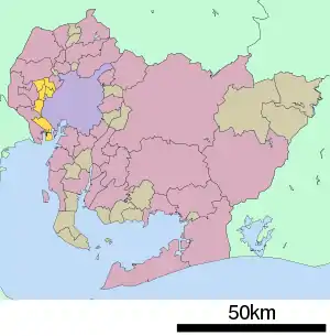
Map of Ama District in Aichi Prefecture
As of October 1, 2019, the district has an estimated population of 74,009 with a density of 1,846 persons per km2. The total area is 40.09 km2.
Municipalities
The district consists of two towns and one village:
- Notes
- Classified as a town.
- Classified as a village.
History
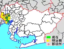
Map showing original extent of Ama District in Aichi Prefecture:
* yellow - areas formerly within the district borders during the early Meiji period
* yellow - areas formerly within the district borders during the early Meiji period
- Ōharu-machi
- Kanie-machi
- Tobishima-mura
Colored areas are in this district.
Recent mergers
- On April 1, 2005 - The towns of Saya and Saori, and the villages of Hachikai and Tatsuta were merged into the expanded city of Aisai.
- On April 1, 2006 - The former town of Yatomi absorbed the village of Jūshiyama to form the city of Yatomi.
- On March 22, 2010 - The towns of Shippō, Jimokuji and Miwa were merged to form the city of Ama.
| Nagoya |
| |||
|---|---|---|---|---|
| Core cities | ||||
| Special city | ||||
| Cities | ||||
| Districts | ||||
| Former Districts | ||||
This article is issued from Wikipedia. The text is licensed under Creative Commons - Attribution - Sharealike. Additional terms may apply for the media files.