Amuda Subdistrict
Amuda Subdistrict (Arabic: ناحية عامودا) is a subdistrict of Qamishli District in northeastern al-Hasakah Governorate, northeastern Syria. Administrative centre is the town Amuda.
Amuda Subdistrict
ناحية عامودا | |
|---|---|
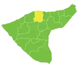 Location of Amuda Subdistrict within al-Hasakah Governorate | |
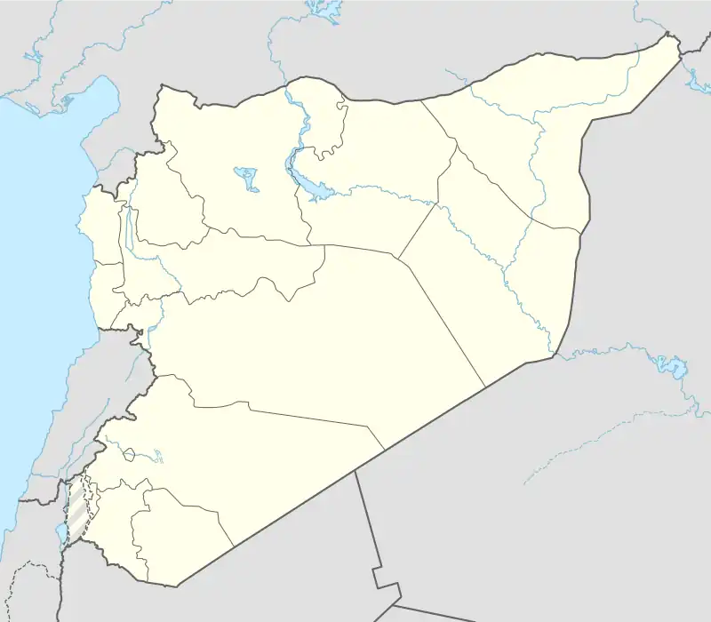 Amuda Subdistrict Location in Syria | |
| Coordinates (Amuda): 36°57′15″N 40°54′52″E | |
| Country | |
| Governorate | al-Hasakah |
| District | Qamishli, Al-Hasakah Governorate |
| Seat | Amuda |
| Area | |
| • Total | 1,034.86 km2 (399.56 sq mi) |
| Population (2004)[1] | 56,101 |
| Geocode | SY080202 |
At the 2004 census, the subdistrict had a population of 56,101.[1]
Cities, towns and villages
| PCode | Name | Population |
|---|---|---|
| C4688 | Amuda | 26,821 |
| C4722 | Raya Gharbi | 1,449 |
| C4729 | Jaberiyeh Amudeh | 934 |
| — | al-Jadidah | 850 |
| — | Bahira | 802 |
| — | Jul Jamal | 700 |
| C4683 | Jorhariyeh | 690 |
| — | Sabah | 687 |
| C4723 | Wardiyeh Amudeh | 652 |
| — | al-Hannia | 650 |
| C4726 | Rihaniyet Amuda | 638 |
| C4706 | Tell Ahmar | 590 |
| C4717 | Umm Rabee | 542 |
| C4719 | Jalaq | 539 |
| C4684 | Tell Khanzir | 531 |
| C4721 | Rayat Elkhalil | 519 |
| — | al-Jum | 503 |
| — | Shawala | 485 |
| C4690 | Fares | 460 |
| — | Tiberia | 450 |
| — | Tell al-Wafa | 445 |
| C4740 | Kinda | 428 |
| C4693 | Tell Habash | 418 |
| C4689 | Hettin Amuda | 407 |
| — | Ghazala Amudeh | 399 |
| C4716 | Um Enab | 365 |
| C4704 | Tell Aswad Amudeh | 336 |
| C4686 | Tell Khaled | 335 |
| C4708 | Umm al-Aswad Tahtani | 334 |
| C4697 | Dar | 317 |
| C4701 | Amara | 300 |
| C4738 | Qleiah | 291 |
| — | ? | 283 |
| C4730 | Bab Elkheir | 278 |
| C4694 | Tawwar Ilias | 273 |
| C4696 | Lower Tell Arus | 272 |
| C4741 | Nif | 272 |
| — | Shaykh | 269 |
| C4720 | Khorzeh | 267 |
| C4731 | Markab | 263 |
| C4724 | Raya Qabli | 253 |
| C4705 | Bardeh | 248 |
| — | Abu al-Hul | 246 |
| — | Umm al-Banat | 234 |
| — | ? | 232 |
| C4691 | Haj Bakari | 230 |
| — | Fawwara | 229 |
| C4713 | Bustan Fawqani | 227 |
| C4712 | Dikiyeh | 226 |
| C4732 | Qaber Ali | 226 |
| — | ? | 218 |
| C4699 | Talil | 206 |
| — | ? | 204 |
| C4725 | Kherbet Elsawda | 201 |
| C4702 | Bustan Tahtani | 201 |
| C4739 | Qayrawan Amuda | 196 |
| C4687 | Abu Khinjar | 191 |
| — | Tell al-Mal | 190 |
| C4682 | Haj Naser | 186 |
| C4707 | Sardaq | 183 |
| — | Jamila | 183 |
| C4727 | Shajra | 182 |
| — | Tabat | 180 |
| — | Alia | 179 |
| C4692 | Hallaba | 179 |
| C4695 | Tell Arbid | 179 |
| C4710 | Karawan | 177 |
| C4709 | Kherbet Ghazal Fawqani | 175 |
| — | ? | 175 |
| — | ? | 175 |
| — | Kherbet Aziz | 170 |
| — | ? | 170 |
| — | Qahera | 169 |
| C4715 | Kherbet Sheib Amuda | 168 |
| C4698 | Hasda Tahtani | 164 |
| — | ? | 164 |
| — | ? | 161 |
| — | ? | 155 |
| C4711 | Sfira Amuda | 153 |
| — | ? | 152 |
| C4735 | Fokhar | 151 |
| C4737 | Koub | 146 |
| — | Milsun | 146 |
| — | ? | 145 |
| — | Adnaniyeh | 140 |
| C4733 | Mustafa | 138 |
| — | ? | 134 |
| — | ? | 133 |
| — | ? | 130 |
| C4718 | Sabahiyeh | 127 |
| C4728 | Deir Mary | 123 |
| C4703 | Billet Bkara | 115 |
| — | ? | 110 |
| C4685 | Hasba | 106 |
| — | ? | 95 |
| C4734 | Mashad | 75 |
| C4714 | Khaled | 65 |
| C4700 | Tell Eshq | 62 |
| — | ? | 49 |
| C4736 | Qadah | 39 |
| — | ? | 38 |
| — | ? | 36 |
| — | Hadba | 17 |
References
- "2004 Census Data for Nahiya Amuda" (in Arabic). Syrian Central Bureau of Statistics. Archived from the original on 4 March 2016. Retrieved 15 October 2015. Also available in English: "2004 Census Data". UN OCHA. Retrieved 15 October 2015.
This article is issued from Wikipedia. The text is licensed under Creative Commons - Attribution - Sharealike. Additional terms may apply for the media files.