Anson County, North Carolina
Anson County is a county located in the U.S. state of North Carolina. As of the 2020 census, the population was 22,055.[1] Its county seat is Wadesboro.[2]
Anson County | |
|---|---|
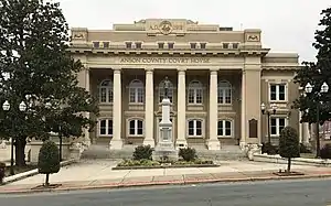 Anson County Courthouse and Confederate Monument in Wadesboro | |
 Flag  Seal | |
| Motto: "Anson County - A great place to call home" | |
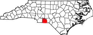 Location within the U.S. state of North Carolina | |
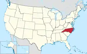 North Carolina's location within the U.S. | |
| Coordinates: 34°58′N 80°06′W | |
| Country | |
| State | |
| Founded | 1750 |
| Named for | George Anson, Baron Anson |
| Seat | Wadesboro |
| Largest community | Wadesboro |
| Area | |
| • Total | 537.10 sq mi (1,391.1 km2) |
| • Land | 531.46 sq mi (1,376.5 km2) |
| • Water | 5.64 sq mi (14.6 km2) 1.05% |
| Population (2020) | |
| • Total | 22,055 |
| • Estimate (2022) | 22,202 |
| • Density | 41.50/sq mi (16.02/km2) |
| Time zone | UTC−5 (Eastern) |
| • Summer (DST) | UTC−4 (EDT) |
| Congressional district | 8th |
| Website | www |
History
The county was formed in 1750 from Bladen County. It was named for George Anson, Baron Anson, a British admiral, who circumnavigated the globe from 1740 to 1744, and later became First Lord of the Admiralty. Anson purchased land in the state.[3]
Like its parent county Bladen being occupied by Native American tribes (Waccamaw people), Anson County was originally occupied by the Catawba Siouan tribe as a vast territory with indefinite northern and western boundaries. Reductions to its extent began in 1753, when the northern part of it became Rowan County. In 1762 the western part of Anson County became Mecklenburg County. In 1779 the northern part of what remained of Anson County became Montgomery County, and the part east of the Pee Dee River became Richmond County. Finally, in 1842 the western part of Anson County was combined with the southeastern part of Mecklenburg County to become Union County.[4]
Geography
According to the U.S. Census Bureau, the county has a total area of 537.10 square miles (1,391.1 km2), of which 531.46 square miles (1,376.5 km2) is land and 5.64 square miles (14.6 km2) (1.05%) is water.[5]
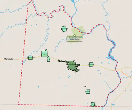
National protected area
State and local protected areas/sites
- Arrowhead Lake[6]
- Gaddy Covered Bridge[7]
- Pee Dee River Game Land (part)[8]
- Wadesboro Downtown Historic District
Major water bodies
- Blewett Falls Lake
- Brown Creek
- Goulds Fork
- Great Pee Dee River
- Lanes Creek
- Rocky River
- Thoroughfare Creek[7]
Adjacent counties
- Stanly County – north
- Montgomery County – northeast
- Richmond County – east
- Chesterfield County, South Carolina – south
- Union County – west
Major infrastructure
Demographics
| Census | Pop. | Note | %± |
|---|---|---|---|
| 1790 | 5,133 | — | |
| 1800 | 8,146 | 58.7% | |
| 1810 | 8,831 | 8.4% | |
| 1820 | 12,534 | 41.9% | |
| 1830 | 14,095 | 12.5% | |
| 1840 | 15,077 | 7.0% | |
| 1850 | 13,489 | −10.5% | |
| 1860 | 13,664 | 1.3% | |
| 1870 | 12,428 | −9.0% | |
| 1880 | 17,994 | 44.8% | |
| 1890 | 20,027 | 11.3% | |
| 1900 | 21,870 | 9.2% | |
| 1910 | 25,465 | 16.4% | |
| 1920 | 28,334 | 11.3% | |
| 1930 | 29,349 | 3.6% | |
| 1940 | 28,443 | −3.1% | |
| 1950 | 26,781 | −5.8% | |
| 1960 | 24,962 | −6.8% | |
| 1970 | 23,488 | −5.9% | |
| 1980 | 25,649 | 9.2% | |
| 1990 | 23,474 | −8.5% | |
| 2000 | 25,275 | 7.7% | |
| 2010 | 26,948 | 6.6% | |
| 2020 | 22,055 | −18.2% | |
| 2022 (est.) | 22,202 | [1] | 0.7% |
| U.S. Decennial Census[9] 1790–1960[10] 1900–1990[11] 1990–2000[12] 2010[13] 2020[1] | |||
2020 census
| Race | Number | Percentage |
|---|---|---|
| White (non-Hispanic) | 10,593 | 48.03% |
| Black or African American (non-Hispanic) | 9,838 | 44.61% |
| Native American | 89 | 0.4% |
| Asian | 221 | 1.0% |
| Pacific Islander | 4 | 0.02% |
| Other/Mixed | 645 | 2.92% |
| Hispanic or Latino | 665 | 3.02% |
As of the 2020 census, there were 22,055 people, 9,521 households, and 5,809 families residing in the county.
2010 census
At the 2010 census, there were 26,948 people. The racial makeup of the county was 48.58% African American, 47.15% White American, 1.07% Asian, 0.61% Native American, 1.25% multiracial and 1.32% of other race. People of Hispanic and Latino origin account for 3.02% of the population.[15]
2000 census
At the 2000 census,[16] there were 25,275 people, 9,204 households, and 6,663 families residing in the county. The population density was 48 people per square mile (19 people/km2). There were 10,221 housing units at an average density of 19 units per square mile (7.3 units/km2). The racial makeup of the county was 51.64% Black or African American, 48.53% White, 0.45% Native American, 0.57% Asian, 0.02% Pacific Islander, 0.32% from other races, and 0.46% from two or more races. 0.83% of the population were Hispanic or Latino of any race.
There were 9,204 households, out of which 31.00% had children under the age of 18 living with them, 47.80% were married couples living together, 19.80% had a female householder with no husband present, and 27.60% were non-families. 25.10% of all households were made up of individuals, and 11.00% had someone living alone who was 65 years of age or older. The average household size was 2.59 and the average family size was 3.09.
In the county, the population was spread out, with 25.20% under the age of 18, 8.60% from 18 to 24, 29.00% from 25 to 44, 22.80% from 45 to 64, and 14.40% who were 65 years of age or older. The median age was 37 years. For every 100 females there were 96.50 males. For every 100 females age 18 and over, there were 95.80 males.
The median income for a household in the county was $29,849, and the median income for a family was $35,870. Males had a median income of $27,297 versus $20,537 for females. The per capita income for the county was $14,853. About 15.50% of families and 17.80% of the population were below the poverty line, including 23.90% of those under age 18 and 16.70% of those age 65 or over.
Government and politics
Anson County is a member of the regional Centralina Council of Governments.[17]
| Year | Republican | Democratic | Third party | |||
|---|---|---|---|---|---|---|
| No. | % | No. | % | No. | % | |
| 2020 | 5,321 | 47.53% | 5,789 | 51.72% | 84 | 0.75% |
| 2016 | 4,506 | 42.73% | 5,859 | 55.56% | 180 | 1.71% |
| 2012 | 4,166 | 37.01% | 7,019 | 62.36% | 71 | 0.63% |
| 2008 | 4,207 | 39.20% | 6,456 | 60.15% | 70 | 0.65% |
| 2004 | 3,796 | 41.15% | 5,413 | 58.68% | 16 | 0.17% |
| 2000 | 3,161 | 39.59% | 4,792 | 60.01% | 32 | 0.40% |
| 1996 | 2,193 | 28.81% | 4,890 | 64.23% | 530 | 6.96% |
| 1992 | 2,334 | 27.33% | 5,269 | 61.71% | 936 | 10.96% |
| 1988 | 2,782 | 36.45% | 4,831 | 63.29% | 20 | 0.26% |
| 1984 | 3,719 | 42.45% | 5,015 | 57.25% | 26 | 0.30% |
| 1980 | 1,968 | 27.77% | 4,973 | 70.17% | 146 | 2.06% |
| 1976 | 1,608 | 25.04% | 4,796 | 74.68% | 18 | 0.28% |
| 1972 | 3,551 | 60.88% | 2,188 | 37.51% | 94 | 1.61% |
| 1968 | 1,474 | 18.39% | 2,969 | 37.05% | 3,571 | 44.56% |
| 1964 | 1,721 | 29.34% | 4,144 | 70.66% | 0 | 0.00% |
| 1960 | 1,597 | 27.93% | 4,120 | 72.07% | 0 | 0.00% |
| 1956 | 1,640 | 31.31% | 3,598 | 68.69% | 0 | 0.00% |
| 1952 | 1,843 | 30.79% | 4,143 | 69.21% | 0 | 0.00% |
| 1948 | 447 | 12.05% | 2,692 | 72.54% | 572 | 15.41% |
| 1944 | 510 | 12.46% | 3,582 | 87.54% | 0 | 0.00% |
| 1940 | 371 | 7.54% | 4,552 | 92.46% | 0 | 0.00% |
| 1936 | 381 | 7.60% | 4,629 | 92.40% | 0 | 0.00% |
| 1932 | 223 | 4.98% | 4,252 | 94.91% | 5 | 0.11% |
| 1928 | 726 | 19.77% | 2,947 | 80.23% | 0 | 0.00% |
| 1924 | 225 | 8.58% | 2,372 | 90.47% | 25 | 0.95% |
| 1920 | 433 | 12.00% | 3,175 | 88.00% | 0 | 0.00% |
| 1916 | 301 | 12.82% | 2,046 | 87.18% | 0 | 0.00% |
| 1912 | 125 | 7.23% | 1,487 | 85.95% | 118 | 6.82% |
Education
There are 11 schools in the Anson County Schools system that serve the students of the county.[19]
South Piedmont Community College has a campus on Highway 74 near Polkton that serves Anson County residents.
Communities
Towns
- Ansonville
- Lilesville
- McFarlan
- Morven
- Peachland
- Polkton
- Wadesboro (county seat and largest community)
Unincorporated communities
- Burnsville
- Fountain Hill
- Lowrys
- Pee Dee
Ghost town
Population ranking
The population ranking is based on a 2023 estimate of Anson County.[20]
† = county seat
| Rank | Name | Type | Population (2023 estimate) |
|---|---|---|---|
| 1 | † Wadesboro | Town | 4,817 |
| 2 | Polkton | Town | 2,195 |
| 3 | Ansonville | Town | 432 |
| 4 | Morven | Town | 345 |
| 5 | Lilesville | Town | 389 |
| 6 | Peachland | Town | 371 |
| 7 | McFarlan | Town | 105 |
Notable people
- Stephone Anthony (born 1992), linebacker with the New Orleans Saints of the NFL
- Hugh Hammond Bennett (1881–1960), soil conservation specialist
- John Culpepper (1761–1841), United States Congressman from North Carolina, and long-tenured Baptist minister
- Blind Boy Fuller (1907–1941), American blues guitarist and vocalist
- James Holland (1754–1823), United States Congressman from North Carolina[21]
- Juanita Moody (1924–2015), cryptographer whose intelligence gathering contributed greatly during the Cuban Missile Crisis
- Leonidas Lafayette Polk (1837–1892), first North Carolina Commissioner of Agriculture
- Sylvester Ritter (1952–1998), professional wrestler also known as "The Junkyard Dog" or "JYD"
In popular culture
Steven Spielberg filmed The Color Purple mostly in Lilesville, and a large white farmhouse (the Huntley House, which is located in Lilesville and is an old farmhouse located few miles off U.S. Route 74) was used extensively as the main exterior location in that film.[22][23]
See also
- List of counties in North Carolina
- National Register of Historic Places listings in Anson County, North Carolina
- Anson County Regiment, militia in the American Revolution
References
- "U.S. Census Bureau QuickFacts: Anson County, North Carolina". United States Census Bureau. Retrieved May 31, 2022.
- "Find a County". National Association of Counties. Archived from the original on May 31, 2011. Retrieved June 7, 2011.
- Gannett (1905). The Origin of Certain Place Names (PDF). Washington DC: United States Geological Survey. p. 26. Archived (PDF) from the original on April 15, 2015.
- Medley, Mary Louise (1976). Anson County Historical Association (ed.). History of Anson County, North Carolina, 1750-1976. Heritage Printer, Inc., Charlotte, North Carolina. ISBN 9780806347554. Retrieved March 3, 2019.
- "2020 County Gazetteer Files – North Carolina". United States Census Bureau. August 23, 2022. Retrieved September 9, 2023.
- "Arrowhead Lake NC Fishing Reports, Map & Hot Spots". www.fishidy.com. Retrieved July 27, 2022.
- "Gaddy Covered Bridge | Natural Atlas". naturalatlas.com. Retrieved July 27, 2022.
- "NCWRC Game Lands". www.ncpaws.org. Retrieved March 30, 2023.
- "U.S. Decennial Census". United States Census Bureau. Retrieved January 11, 2015.
- "Historical Census Browser". University of Virginia Library. Retrieved January 11, 2015.
- Forstall, Richard L., ed. (March 27, 1995). "Population of Counties by Decennial Census: 1900 to 1990". United States Census Bureau. Retrieved January 11, 2015.
- "Census 2000 PHC-T-4. Ranking Tables for Counties: 1990 and 2000" (PDF). United States Census Bureau. April 2, 2001. Archived (PDF) from the original on March 27, 2010. Retrieved January 11, 2015.
- "State & County QuickFacts". United States Census Bureau. Archived from the original on June 6, 2011. Retrieved October 17, 2013.
- "Explore Census Data". data.census.gov. Retrieved December 22, 2021.
- "2010 Census Population of Anson County, NC". Retrieved January 28, 2021.
- "U.S. Census website". United States Census Bureau. Retrieved January 31, 2008.
- "Centralina Council of Governments". Archived from the original on April 10, 2019. Retrieved August 10, 2019.
- Leip, David. "Dave Leip's Atlas of U.S. Presidential Elections". uselectionatlas.org. Retrieved March 14, 2018.
- "Search for Public School Districts – District Detail for Anson County Schools". National Center for Education Statistics. Institute of Education Sciences. Retrieved December 4, 2012.
- "Anson County NC - Cities, Towns, Neighborhoods, & Subdivisions". northcarolina.hometownlocator.com. Retrieved April 30, 2022.
- Who Was Who in America, Historical Volume, 1607-1896. Chicago: Marquis Who's Who. 1963.
- "The Color Purple House". Old House Dreams. September 10, 2010. Retrieved May 23, 2022.
- Sharma, Dhruv (May 12, 2020). "Where Was The Color Purple Filmed?". The Cinemaholic. Retrieved May 23, 2022.
External links
 Geographic data related to Anson County, North Carolina at OpenStreetMap
- Official website
Places adjacent to Anson County, North Carolina | ||||||||||||||||
|---|---|---|---|---|---|---|---|---|---|---|---|---|---|---|---|---|
| ||||||||||||||||
Municipalities and communities of Anson County, North Carolina, United States | ||
|---|---|---|
| Towns | 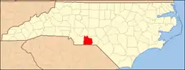 | |
| Unincorporated community | ||
| Ghost town | ||
|  | ||||||||||||
|
| |||||||||||||