Arapaoa Island
Arapaoa Island (formerly spelled Arapawa Island) is the second-largest island in the Marlborough Sounds, at the north-east tip of the South Island of New Zealand. The island has a land area of 75 km2 (29 square miles). Queen Charlotte Sound defines its western side, while to the south lies Tory Channel, which is on the sea route between Wellington in the North Island to Picton. Cook Strait's narrowest point is between Arapaoa Island's Perano Head and Cape Terawhiti in the North Island.
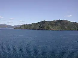
 Southern end of Arapaoa Island | |
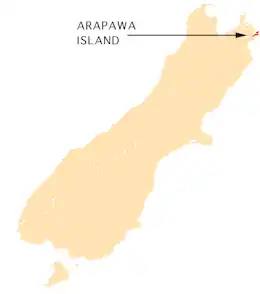
 Arapaoa Island relative to the South Island | |
| Geography | |
|---|---|
| Location | Marlborough Sounds |
| Coordinates | 41.18951°S 174.30290°E |
| Area | 75 km2 (29 sq mi) |
| Length | 28 km (17.4 mi) |
| Width | 4 km (2.5 mi) |
| Highest elevation | 559.4 m (1835.3 ft) |
| Highest point | Narawhia |
| Administration | |
New Zealand | |
| Region | Marlborough District |
| Demographics | |
| Population | 50 |
History
According to Māori oral tradition, the island was where the great navigator Kupe killed the octopus Te Wheke-a-Muturangi.[1]
It was from a hill on Arapaoa Island in 1770 that Captain James Cook first saw the sea passage from the Pacific Ocean to the Tasman Sea, which was named Cook Strait. This discovery banished the fond notion of geographers that there existed a great southern continent, Terra Australis. A monument at Cook's Lookout was erected in 1970.
From the late 1820s until the mid-1960s, Arapaoa Island was a base for whaling in the Sounds. John Guard established a shore station at Te Awaiti in 1827, however initially could only salvage baleen until the station was equipped to process whale oil from 1830 onwards, targeting right whales.[2] Later, the station at Perano Head on the east coast of the island was used to hunt humpback whales from 1911 to 1964 (see Whaling in New Zealand). The houses built by the Perano family are now operated as tourist accommodation. In the 2000s the former whalers from the Perano and Heberley families, who live on Arapawa, joined a Department of Conservation whale spotting programme to assess how the humpback whale population has recovered since the end of whaling.[3][4][5]
An Air Albatross Cessna 402 commuter aircraft struck the 11,000-volt power lines linking the island and the mainland over Tory Channel in 1985. The crash was witnessed by many passengers on an inter-island Cook Strait ferry. The ferry immediately stopped to dispatch a rescue lifeboat. Along with the two pilots, one entire family died, and all but a young girl from the other. No bodies were ever found. The sole survivor (Cindy Mosey) was travelling with her family and the other family from Nelson to Wellington to attend a gymnastics competition. The Arapaoa Island crash caused public confidence in Air Albatross to falter, contributing to the company going into liquidation in December of that year.
In August 2014, the spelling of the island's name was officially changed from Arapawa to Arapaoa.[6]
Conservation
Parts of the island have been heavily cleared of native vegetation in the past through burning and logging, A number of pine forests were planted on the island.[7] Wilding pines, an invasive species in some parts of New Zealand, are being poisoned on the island to allow the regenerating native vegetation to grow. About 200 hectares (490 acres) at Ruaomoko Point on the south-eastern portion of the island will be killed by drilling holes into the trees and injecting poison.[8]
Arapaoa Island is known for the breeds of domestic animals found only on the island – the Arapawa pig, Arapawa sheep and Arapawa goat. They became established in the 19th century, but the origin of the breeds is uncertain, and a matter of some speculation. Common suggestions are that they are old English breeds introduced by the early whalers, or by Captain Cook or other early explorers. These breeds are now extinct in England, and the goats surviving in a sanctuary on the island are now also bred in other parts of New Zealand and in the northern hemisphere.
The small Brothers Islands, which lie off the northeast coast of Arapaoa Island, are a sanctuary for the rare Brothers Island tuatara.
See also
References
- "New and altered geographic names of Te Tau Ihu". theprow.org.nz. 2014. Retrieved 7 November 2015.
- Prickett, Nigel (1983). "AN ARCHAEOLOGICAL RECONNAISSANCE OF THE SHORE WHALING INDUSTRY ON KAPITI ISLAND, NEW ZEALAND". Records of the Auckland Institute and Museum. 20: 41–63. ISSN 0067-0464.
- Johnston, Kirsty (26 July 2011). "Killers to conservationists". Stuff. Archived from the original on 15 May 2021. Retrieved 15 May 2021.
- Angeloni, Alice (12 January 2020). "Whaling: The rise and fall of New Zealand's oldest, most ruthless industry". Stuff. Archived from the original on 12 January 2020. Retrieved 15 May 2021.
- "Interview with Joe (Joseph) Heberley". tiaki.natlib.govt.nz. Archived from the original on 4 February 2016. Retrieved 15 May 2021.
- "NZGB decisions". Land Information New Zealand. August 2014. Archived from the original on 21 November 2015. Retrieved 7 November 2015.
- Meurk, C. D; Ward J.C.; Jane G.; Walls G.Y. (1999). "Arapawa Island: flora and ecological notes" (PDF). Canterbury Botanical Society (33): 77–98. Archived (PDF) from the original on 9 October 2022.
- Nicoll, Jared (22 June 2012). "Tree poisoning work for island". The Marlborough Express. Retrieved 24 February 2013.
Further reading
- Philp, Matt. 2011. The Sound of the Sea. New Zealand Geographic, 110.
- Heberley, Heather. 1996. Weather permitting. Whatamango Bay, N.Z. : Cape Catley. ISBN 0908561490
- Heberley, Heather. 1997. Flood tide. Whatamango Bay, N.Z. : Cape Catley. ISBN 090856161X