Argillite, Kentucky
Argillite is an unincorporated community on the Little Sandy River in Greenup County, Kentucky, United States. It sits at the southern end of the confluence of Kentucky Routes 1 and 207. The name refers to argillite, a type of stone, related to shale.[2]
Argillite, Kentucky | |
|---|---|
 Argillite, Kentucky | |
| Coordinates: 38.489237°N 82.828674°W | |
| Country | United States |
| State | Kentucky |
| County | Greenup |
| Elevation | 541 ft (165 m) |
| Time zone | UTC-5 (Eastern (EST)) |
| • Summer (DST) | UTC-4 (EDT) |
| ZIP code | 41121 |
| Area code | 606 |
| GNIS feature ID | 507409[1] |
Argillite was a stop along the Eastern Kentucky Railway between the Simonton and Laurel stops.[3] Argillite's ZIP Code is 41121.[4]
Notable person
- Jeremy Bates, heavyweight boxer
References
- "Argillite". Geographic Names Information System. United States Geological Survey, United States Department of the Interior.
- Greenup County Postcard History (2021, Baldridge, Terry L.)
- Eastern Kentucky Railway (2007, Baldridge, Terry L.)
- "Look Up a ZIP Code". USPS.com. United States Postal Service. Retrieved July 16, 2020.
Municipalities and communities of Greenup County, Kentucky, United States | ||
|---|---|---|
| Cities | 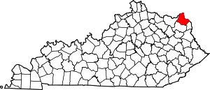 | |
| Unincorporated communities | ||
This article is issued from Wikipedia. The text is licensed under Creative Commons - Attribution - Sharealike. Additional terms may apply for the media files.