Arlington, Iowa
Arlington is a city in Fayette County, Iowa, United States. The population was 419 in the 2020 census, a decline from the 490 population in the 2000 census.[2][3][4]
Arlington, Iowa | |
|---|---|
| Motto(s): Where hills and prairie meet. | |
 Location of Arlington, Iowa | |
| Coordinates: 42°44′53″N 91°40′18″W | |
| Country | |
| State | |
| County | Fayette |
| Area | |
| • Total | 1.00 sq mi (2.60 km2) |
| • Land | 1.00 sq mi (2.60 km2) |
| • Water | 0.00 sq mi (0.00 km2) |
| Elevation | 1,129 ft (344 m) |
| Population (2020) | |
| • Total | 419 |
| • Density | 417.75/sq mi (161.23/km2) |
| Time zone | UTC-6 (Central (CST)) |
| • Summer (DST) | UTC-5 (CDT) |
| ZIP code | 50606 |
| Area code | 563 |
| FIPS code | 19-02845 |
| GNIS feature ID | 0454230 |

History
Arlington was originally called Brush Creek.[5] The community was first settled in 1854.
Geography
Arlington is located at 42°44′53″N 91°40′18″W (42.748095, -91.671545)[6] just north of the headwaters of the Maquoketa River.
According to the United States Census Bureau, the city has a total area of 1.05 square miles (2.72 km2), all land.[7]
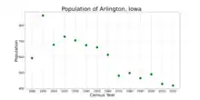
Demographics
| Census | Pop. | Note | %± |
|---|---|---|---|
| 1890 | 593 | — | |
| 1900 | 863 | 45.5% | |
| 1910 | 678 | −21.4% | |
| 1920 | 729 | 7.5% | |
| 1930 | 706 | −3.2% | |
| 1940 | 675 | −4.4% | |
| 1950 | 661 | −2.1% | |
| 1960 | 614 | −7.1% | |
| 1970 | 481 | −21.7% | |
| 1980 | 498 | 3.5% | |
| 1990 | 465 | −6.6% | |
| 2000 | 490 | 5.4% | |
| 2010 | 429 | −12.4% | |
| 2020 | 419 | −2.3% | |
| U.S. Decennial Census[8] | |||

2010 census
As of the census[9] of 2010, there were 429 people, 191 households, and 122 families living in the city. The population density was 408.6 inhabitants per square mile (157.8/km2). There were 212 housing units at an average density of 201.9 per square mile (78.0/km2). The racial makeup of the city was 98.8% White, 0.7% Native American, 0.2% Asian, and 0.2% from two or more races.
There were 191 households, of which 27.7% had children under the age of 18 living with them, 51.8% were married couples living together, 8.4% had a female householder with no husband present, 3.7% had a male householder with no wife present, and 36.1% were non-families. 31.4% of all households were made up of individuals, and 16.7% had someone living alone who was 65 years of age or older. The average household size was 2.25 and the average family size was 2.79.
The median age in the city was 45.5 years. 20% of residents were under the age of 18; 8.9% were between the ages of 18 and 24; 20.6% were from 25 to 44; 32.2% were from 45 to 64; and 18.4% were 65 years of age or older. The gender makeup of the city was 49.4% male and 50.6% female.
2000 census
As of the census[10] of 2000, there were 490 people, 212 households, and 140 families living in the city. The population density was 467.4 inhabitants per square mile (180.5/km2). There were 230 housing units at an average density of 219.4 per square mile (84.7/km2). The racial makeup of the city was 99.39% White, 0.41% Native American and 0.20% Asian.
There were 212 households, out of which 25.9% had children under the age of 18 living with them, 52.4% were married couples living together, 9.4% had a female householder with no husband present, and 33.5% were non-families. 30.2% of all households were made up of individuals, and 17.5% had someone living alone who was 65 years of age or older. The average household size was 2.31 and the average family size was 2.87.
In the city, the population was spread out, with 25.9% under the age of 18, 5.3% from 18 to 24, 22.4% from 25 to 44, 24.7% from 45 to 64, and 21.6% who were 65 years of age or older. The median age was 43 years. For every 100 females, there were 83.5 males. For every 100 females age 18 and over, there were 83.3 males.
The median income for a household in the city was $30,357, and the median income for a family was $37,083. Males had a median income of $25,938 versus $17,031 for females. The per capita income for the city was $14,643. About 11.9% of families and 14.9% of the population were below the poverty line, including 24.6% of those under age 18 and 12.5% of those age 65 or over.
Education
Arlington is served by Starmont Community School District that includes a high school, middle school and elementary school.[11]
Transportation
Arlington is located on Iowa Highway 187.[12]
Notable people
- Percy R. Kelly (1870–1949) 26th Chief Justice of the Oregon Supreme Court[13]
- Brian Schoenjahn, Iowa State Senator from the 12th District[14]
- William Henry Thompson (1853–1937) United States Senator for the state of Nebraska[5]
References
- "2020 U.S. Gazetteer Files". United States Census Bureau. Retrieved March 16, 2022.
- "2020 Census State Redistricting Data". census.gov. United states Census Bureau. Retrieved August 12, 2021.
- "Population & Housing Occupancy Status 2010" (PDF). United States Census Bureau American FactFinder. Retrieved August 15, 2022.
- "Data from the 2010 Census". State Data Center of Iowa. Archived from the original on July 26, 2011. Retrieved September 22, 2011.
- "THOMPSON, William Henry". Biographical Directory of the United States Congress. Retrieved September 21, 2011.
- "US Gazetteer files: 2010, 2000, and 1990". United States Census Bureau. February 12, 2011. Retrieved April 23, 2011.
- "US Gazetteer files 2010". United States Census Bureau. Archived from the original on January 25, 2012. Retrieved May 11, 2012.
- "Census of Population and Housing". Census.gov. Retrieved June 4, 2015.
- "U.S. Census website". United States Census Bureau. Retrieved May 11, 2012.
- "U.S. Census website". United States Census Bureau. Retrieved January 31, 2008.
- "Home Page". Starmont Community School District. Retrieved September 22, 2011.
- "Arlington, Iowa". MapQuest. Retrieved September 22, 2011.
- "Index to Politicians Kelly, O to R". The Political Graveyard. Retrieved September 22, 2011.
- "Senator Brian H. Schoenjahn". Project Vote Smart. Retrieved September 22, 2011.
External links
- Welcome to Arlington A portal style website